Pănceşti elevation
Pănceşti (Bacău, Comuna Pănceşti), Romania elevation is 195 meters and Pănceşti elevation in feet is 640 ft above sea level [src 1]. Pănceşti is a seat of a second-order administrative division (feature code) with elevation that is 57 meters (187 ft) smaller than average city elevation in Romania.
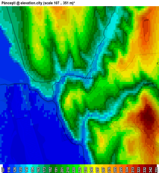
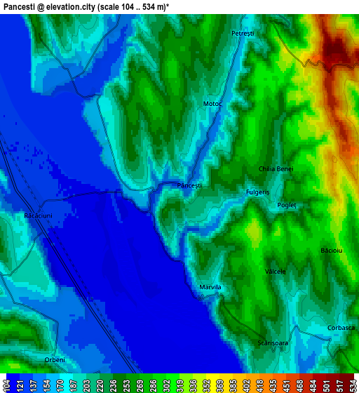
Below is the Elevation map of Pănceşti, which displays elevation range with different colors. Scale of the first map is from 107 to 351 m (351 to 1152 ft) with average elevation of 191.1 meters (=627 ft) [note 1]
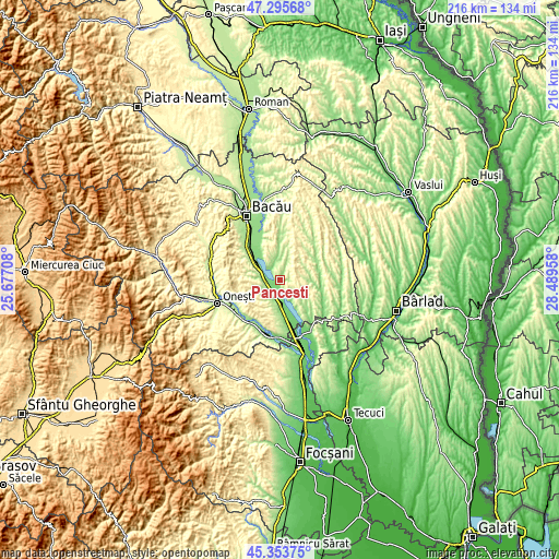
These maps also provides idea of topography and contour of this city, they are displayed at different zoom levels. More info about maps, scale and edge coordinates you can find below images.
| \ | Map #1 | Map #2 | Topo.Map |
| Scale [m] | 107..351 m | 104..534 m | × |
| Scale [ft] | 351..1152 ft | 341..1752 ft | × |
| Average | 191.1 m = 627 ft | 205.8 m = 675 ft | × |
| Width | 6.75 km = 4.2 mi | 13.5 km = 8.4 mi | 215.9 km = 134.2 mi |
| Height | 6.75 km = 4.2 mi | 13.5 km = 8.4 mi | 215.9 km = 134.2 mi |
| ↑Max Latitude | 46.363664° | 46.393981° | 47.29568° |
| Latitude at center | 46.33333° | 46.33333° | 46.33333° |
| ↓Min Latitude | 46.302979° | 46.272611° | 45.35375° |
| ← Min Longitude | 27.039385° | 26.995439° | 25.67708° |
| Longitude center | 27.08333° | 27.08333° | 27.08333° |
| →Max Longitude | 27.127275° | 27.171221° | 28.48958° |
Nearby cities:
Cities around Pănceşti sort by population:
• Răcăciuni elevation 216 m
7.7 km,  270°
270°
• Corbasca 255 m
8.5 km,  130°
130°
• Horgeşti 230 m
11.2 km,  353°
353°
• Orbeni 220 m
7.6 km,  222°
222°
• Parava 160 m
7.4 km,  239°
239°
• Găiceana 189 m
10.2 km,  90°
90°
• Dealu Morii 265 m
11.7 km,  99°
99°
• Valea Seacă 199 m
10.5 km,  195°
195°
• Scurta 202 m
9.6 km,  213°
213°
• Băcioiu 277 m
6.1 km,  110°
110°
• Arini 257 m
7.9 km,  76°
76°
• Gheorghe Doja 143 m
10.5 km,  298°
298°
Multilingual:
 En español:
Pănceşti elevación 195 m.
 En France:
Pănceşti élévation 195 m.
 Auf Deutsch:
Pănceşti höhe über dem Meeresspiegel ist 195 m.

Sources and notes:
- [note 1] Map square and city borders are not equal. Map elevation data is calculated only from area inside that square.
- [src 1] Elevation data from geonames database provided with same terms of usage.
- [src 2] The elevation map of Pănceşti is generated using elevation data from NASA's 3 arcsec (90m) resolution SRTM data.
- [src 3] Base (background) map © OpenStreetMap contributors tiles are generated by Geofabrik and OpenTopoMap.
Copyright & License:
This Pănceşti Elevation Map is licensed under CC BY-SA. You may reuse any part from this page, if you give a proper credit by linking to this URL:
 More info on terms of use page.