Periş elevation
Periş (Ilfov, Comuna Periş), Romania elevation is 108 meters and Periş elevation in feet is 354 ft above sea level [src 1]. Periş is a seat of a second-order administrative division (feature code) with elevation that is 144 meters (472 ft) smaller than average city elevation in Romania.
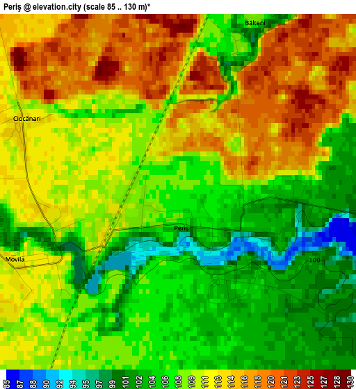
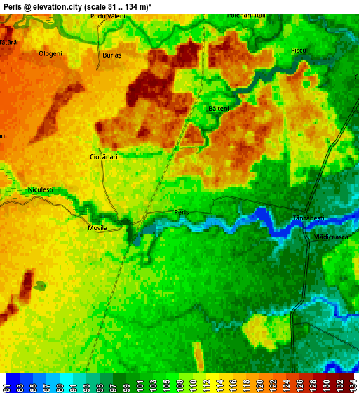
Below is the Elevation map of Periş, which displays elevation range with different colors. Scale of the first map is from 85 to 130 m (279 to 427 ft) with average elevation of 109.5 meters (=359 ft) [note 1]
These maps also provides idea of topography and contour of this city, they are displayed at different zoom levels. More info about maps, scale and edge coordinates you can find below images.
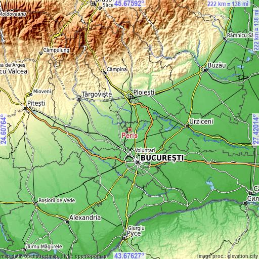
| \ | Map #1 | Map #2 | Topo.Map |
| Scale [m] | 85..130 m | 81..134 m | × |
| Scale [ft] | 279..427 ft | 266..440 ft | × |
| Average | 109.5 m = 359 ft | 109 m = 358 ft | × |
| Width | 6.95 km = 4.3 mi | 13.9 km = 8.6 mi | 222.3 km = 138.1 mi |
| Height | 6.95 km = 4.3 mi | 13.9 km = 8.6 mi | 222.3 km = 138.1 mi |
| ↑Max Latitude | 44.715956° | 44.747175° | 45.67592° |
| Latitude at center | 44.68472° | 44.68472° | 44.68472° |
| ↓Min Latitude | 44.653467° | 44.622197° | 43.67627° |
| ← Min Longitude | 25.969945° | 25.925999° | 24.60764° |
| Longitude center | 26.01389° | 26.01389° | 26.01389° |
| →Max Longitude | 26.057835° | 26.101781° | 27.42014° |
Nearby cities:
Cities around Periş sort by population:
• Ciolpani elevation 105 m
7.7 km,  45°
45°
• Corbeanca 97 m
9.8 km,  163°
163°
• Niculești 116 m
5.7 km,  267°
267°
• Butimanu 121 m
9 km, 269°
• Ologeni 120 m
7.4 km,  317°
317°
• Dârza 109 m
10.5 km,  208°
208°
• Ghermănești 90 m
10.7 km,  87°
87°
• Poienarii Apostoli 112 m
10.2 km,  18°
18°
• Buriaș 119 m
6 km,  333°
333°
• Ciocănari 112 m
3.2 km,  296°
296°
• Poienarii Burchii 113 m
7.3 km,  1°
1°
• Ciofliceni 94 m
8.3 km, 92°
Multilingual:
 En español:
Periş elevación 108 m.
 En France:
Periş élévation 108 m.


Sources and notes:
- [note 1] Map square and city borders are not equal. Map elevation data is calculated only from area inside that square.
- [src 1] Elevation data from geonames database provided with same terms of usage.
- [src 2] The elevation map of Periş is generated using elevation data from NASA's 3 arcsec (90m) resolution SRTM data.
- [src 3] Base (background) map © OpenStreetMap contributors tiles are generated by Geofabrik and OpenTopoMap.
Copyright & License:
This Periş Elevation Map is licensed under CC BY-SA. You may reuse any part from this page, if you give a proper credit by linking to this URL:
 More info on terms of use page.