Petrila elevation
Petrila (Hunedoara, Oraş Petrila), Romania elevation is 676 meters and Petrila elevation in feet is 2218 ft above sea level [src 1]. Petrila is a seat of a second-order administrative division (feature code) with elevation that is 424 meters (1391 ft) bigger than average city elevation in Romania.
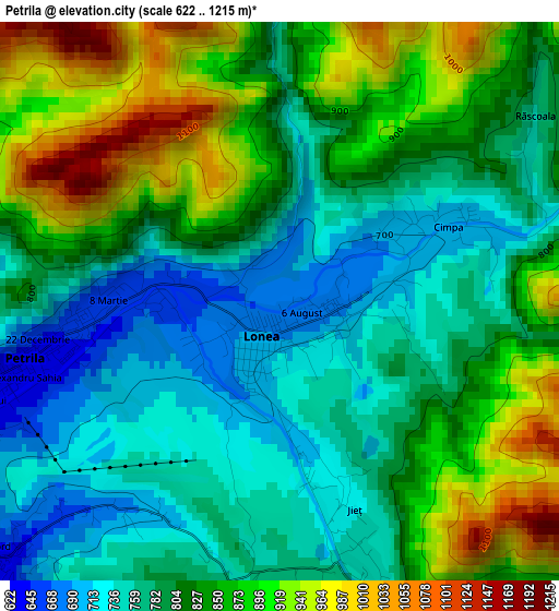
Below is the Elevation map of Petrila, which displays elevation range with different colors. Scale of the first map is from 622 to 1215 m (2041 to 3986 ft) with average elevation of 821 meters (=2694 ft) [note 1]
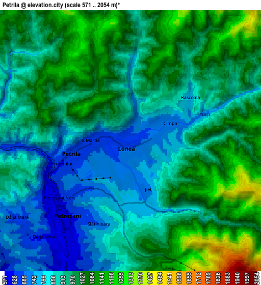
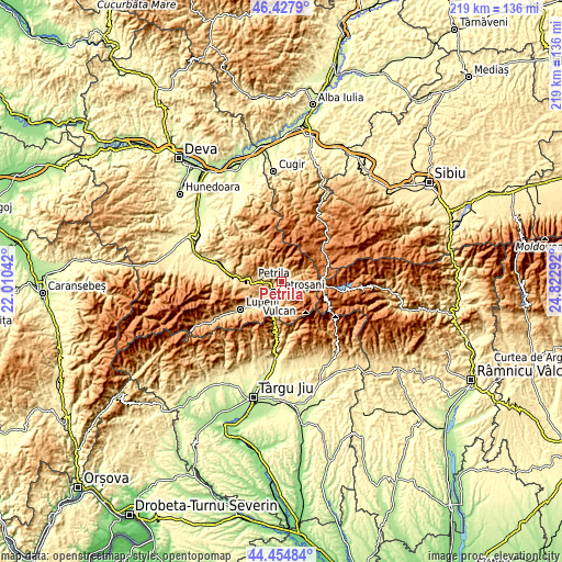
These maps also provides idea of topography and contour of this city, they are displayed at different zoom levels. More info about maps, scale and edge coordinates you can find below images.
| \ | Map #1 | Map #2 | Topo.Map |
| Scale [m] | 622..1215 m | 571..2054 m | × |
| Scale [ft] | 2041..3986 ft | 1873..6739 ft | × |
| Average | 821 m = 2694 ft | 945.8 m = 3103 ft | × |
| Width | 6.86 km = 4.3 mi | 13.71 km = 8.5 mi | 219.4 km = 136.3 mi |
| Height | 6.86 km = 4.3 mi | 13.71 km = 8.5 mi | 219.4 km = 136.3 mi |
| ↑Max Latitude | 45.480821° | 45.511624° | 46.4279° |
| Latitude at center | 45.45° | 45.45° | 45.45° |
| ↓Min Latitude | 45.419163° | 45.388308° | 44.45484° |
| ← Min Longitude | 23.372725° | 23.328779° | 22.01042° |
| Longitude center | 23.41667° | 23.41667° | 23.41667° |
| →Max Longitude | 23.460615° | 23.504561° | 24.82292° |
Nearby cities:
Cities around Petrila sort by population:
• Petroşani elevation 606 m
5.4 km,  226°
226°
• Lupeni 634 m
17.1 km, 234°
• Vulcan 757 m
13.9 km,  237°
237°
• Bumbeşti-Jiu 380 m
31.5 km,  182°
182°
• Uricani 692 m
24.1 km, 238°
• Aninoasa 643 m
9.1 km, 240°
• Pui 412 m
25.8 km,  286°
286°
• Baru Mic 525 m
20.9 km,  275°
275°
• Jiu-Paroșeni 640 m
15.7 km, 231°
• Iscroni 568 m
9.9 km,  216°
216°
• Băniţa 756 m
11.7 km,  270°
270°
• Baru 474 m
20 km, 277°
Multilingual:
 En español:
Petrila elevación 676 m.
 En France:
Petrila élévation 676 m.


Sources and notes:
- [note 1] Map square and city borders are not equal. Map elevation data is calculated only from area inside that square.
- [src 1] Elevation data from geonames database provided with same terms of usage.
- [src 2] The elevation map of Petrila is generated using elevation data from NASA's 3 arcsec (90m) resolution SRTM data.
- [src 3] Base (background) map © OpenStreetMap contributors tiles are generated by Geofabrik and OpenTopoMap.
Copyright & License:
This Petrila Elevation Map is licensed under CC BY-SA. You may reuse any part from this page, if you give a proper credit by linking to this URL:
 More info on terms of use page.