Pleniţa elevation
Pleniţa (Dolj, Comuna Pleniţa), Romania elevation is 146 meters and Pleniţa elevation in feet is 479 ft above sea level [src 1]. Pleniţa is a seat of a second-order administrative division (feature code) with elevation that is 106 meters (348 ft) smaller than average city elevation in Romania.
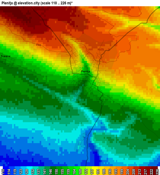
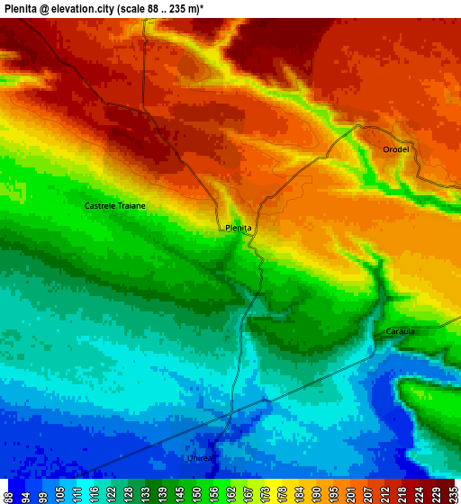
Below is the Elevation map of Pleniţa, which displays elevation range with different colors. Scale of the first map is from 110 to 226 m (361 to 741 ft) with average elevation of 164.4 meters (=539 ft) [note 1]
These maps also provides idea of topography and contour of this city, they are displayed at different zoom levels. More info about maps, scale and edge coordinates you can find below images.
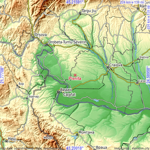
| \ | Map #1 | Map #2 | Topo.Map |
| Scale [m] | 110..226 m | 88..235 m | × |
| Scale [ft] | 361..741 ft | 289..771 ft | × |
| Average | 164.4 m = 539 ft | 160.6 m = 527 ft | × |
| Width | 7 km = 4.3 mi | 14.01 km = 8.7 mi | 224.1 km = 139.2 mi |
| Height | 7 km = 4.3 mi | 14.01 km = 8.7 mi | 224.1 km = 139.2 mi |
| ↑Max Latitude | 44.248158° | 44.279628° | 45.21591° |
| Latitude at center | 44.21667° | 44.21667° | 44.21667° |
| ↓Min Latitude | 44.185166° | 44.153644° | 43.20018° |
| ← Min Longitude | 23.139385° | 23.095439° | 21.77708° |
| Longitude center | 23.18333° | 23.18333° | 23.18333° |
| →Max Longitude | 23.227275° | 23.271221° | 24.58958° |
Nearby cities:
Cities around Pleniţa sort by population:
• Unirea elevation 95 m
7.4 km,  180°
180°
• Oprişor 205 m
10.9 km,  312°
312°
• Dârvari 109 m
10.8 km,  260°
260°
• Carpen 237 m
14 km,  22°
22°
• Caraula 102 m
6.5 km,  124°
124°
• Izvoare 130 m
11.8 km,  130°
130°
• Vârtop 135 m
13.2 km,  94°
94°
• Verbiţa 220 m
9.4 km,  351°
351°
• Gemeni 97 m
9.4 km,  238°
238°
• Castrele Traiane 157 m
3.8 km,  290°
290°
• Orodel 166 m
4.4 km,  65°
65°
• Dobridor 71 m
11 km,  185°
185°
Multilingual:
 En español:
Pleniţa elevación 146 m.
 En France:
Pleniţa élévation 146 m.


Sources and notes:
- [note 1] Map square and city borders are not equal. Map elevation data is calculated only from area inside that square.
- [src 1] Elevation data from geonames database provided with same terms of usage.
- [src 2] The elevation map of Pleniţa is generated using elevation data from NASA's 3 arcsec (90m) resolution SRTM data.
- [src 3] Base (background) map © OpenStreetMap contributors tiles are generated by Geofabrik and OpenTopoMap.
Copyright & License:
This Pleniţa Elevation Map is licensed under CC BY-SA. You may reuse any part from this page, if you give a proper credit by linking to this URL:
 More info on terms of use page.