Poieni elevation
Poieni (Neamţ, Comuna Piatra Şoimului), Romania elevation is 528 meters and Poieni elevation in feet is 1732 ft above sea level [src 1]. Poieni is a populated place (feature code) with elevation that is 276 meters (906 ft) bigger than average city elevation in Romania.
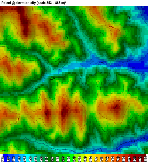
Below is the Elevation map of Poieni, which displays elevation range with different colors. Scale of the first map is from 353 to 885 m (1158 to 2904 ft) with average elevation of 590 meters (=1936 ft) [note 1]
These maps also provides idea of topography and contour of this city, they are displayed at different zoom levels. More info about maps, scale and edge coordinates you can find below images.
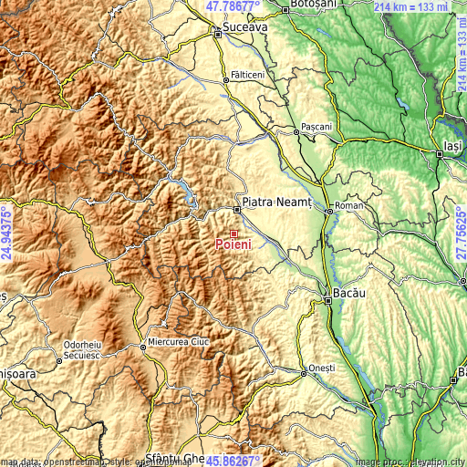
| \ | Map #1 | Topo.Map |
| Scale [m] | 353..885 m | × |
| Scale [ft] | 1158..2904 ft | × |
| Average | 590 m = 1936 ft | × |
| Width | 6.69 km = 4.2 mi | 213.9 km = 132.9 mi |
| Height | 6.69 km = 4.2 mi | 213.9 km = 132.9 mi |
| ↑Max Latitude | 46.863386° | 47.78677° |
| Latitude at center | 46.83333° | 46.83333° |
| ↓Min Latitude | 46.803258° | 45.86267° |
| ← Min Longitude | 26.306055° | 24.94375° |
| Longitude center | 26.35° | 26.35° |
| →Max Longitude | 26.393945° | 27.75625° |
Nearby cities:
Cities around Poieni sort by population:
• Piatra Neamţ elevation 508 m
9.4 km,  352°
352°
• Borleşti 355 m
12.6 km,  126°
126°
• Roznov 269 m
12.7 km,  90°
90°
• Piatra Şoimului 325 m
6.3 km, 90°
• Dumbrava Roşie 299 m
8.4 km,  48°
48°
• Săvineşti 274 m
9.1 km,  78°
78°
• Luminiș 310 m
8.1 km,  105°
105°
• Cut 299 m
7.6 km,  43°
43°
• Mastacăn 349 m
11.5 km,  115°
115°
• Văleni 306 m
8.3 km,  21°
21°
• Izvoare 327 m
12.5 km, 46°
• Chintinici 268 m
10.9 km, 93°
Multilingual:
 En español:
Poieni elevación 528 m.
 En France:
Poieni élévation 528 m.


Sources and notes:
- [note 1] Map square and city borders are not equal. Map elevation data is calculated only from area inside that square.
- [src 1] Elevation data from geonames database provided with same terms of usage.
- [src 2] The elevation map of Poieni is generated using elevation data from NASA's 3 arcsec (90m) resolution SRTM data.
- [src 3] Base (background) map © OpenStreetMap contributors tiles are generated by Geofabrik and OpenTopoMap.
Copyright & License:
This Poieni Elevation Map is licensed under CC BY-SA. You may reuse any part from this page, if you give a proper credit by linking to this URL:
 More info on terms of use page.