Poiana Mare elevation
Poiana Mare (Dolj, Comuna Poiana Mare), Romania elevation is 41 meters and Poiana Mare elevation in feet is 135 ft above sea level [src 1]. Poiana Mare is a seat of a second-order administrative division (feature code) with elevation that is 211 meters (692 ft) smaller than average city elevation in Romania.
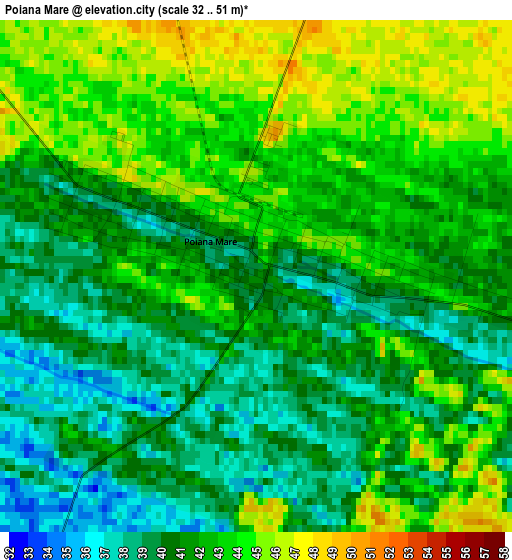
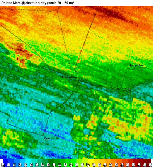
Below is the Elevation map of Poiana Mare, which displays elevation range with different colors. Scale of the first map is from 32 to 51 m (105 to 167 ft) with average elevation of 41.4 meters (=136 ft) [note 1]
These maps also provides idea of topography and contour of this city, they are displayed at different zoom levels. More info about maps, scale and edge coordinates you can find below images.
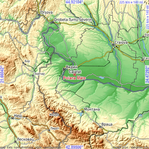
| \ | Map #1 | Map #2 | Topo.Map |
| Scale [m] | 32..51 m | 29..60 m | × |
| Scale [ft] | 105..167 ft | 95..197 ft | × |
| Average | 41.4 m = 136 ft | 43 m = 141 ft | × |
| Width | 7.04 km = 4.4 mi | 14.08 km = 8.7 mi | 225.3 km = 140 mi |
| Height | 7.04 km = 4.4 mi | 14.08 km = 8.7 mi | 225.3 km = 140 mi |
| ↑Max Latitude | 43.948318° | 43.979948° | 44.92104° |
| Latitude at center | 43.91667° | 43.91667° | 43.91667° |
| ↓Min Latitude | 43.885006° | 43.853324° | 42.89506° |
| ← Min Longitude | 23.022725° | 22.978779° | 21.66042° |
| Longitude center | 23.06667° | 23.06667° | 23.06667° |
| →Max Longitude | 23.110615° | 23.154561° | 24.47292° |
Nearby cities:
Cities around Poiana Mare sort by population:
• Calafat elevation 44 m
13.5 km,  307°
307°
• Ciupercenii Noi 40 m
9.5 km,  265°
265°
• Maglavit 73 m
13.2 km,  11°
11°
• Piscu Vechi 37 m
8.2 km,  103°
103°
• Desa 37 m
6.2 km,  205°
205°
• Ciupercenii Vechi 38 m
14.1 km,  282°
282°
• Seaca de Câmp 41 m
12.2 km,  81°
81°
• Hunia 79 m
15.6 km, 9°
• Smârdan 40 m
8.3 km, 283°
• Basarabi 64 m
10.9 km,  335°
335°
• Piscu Nou 39 m
9 km, 84°
• Ghidici 34 m
10.6 km,  105°
105°
Multilingual:
 En español:
Poiana Mare elevación 41 m.
 En France:
Poiana Mare élévation 41 m.
 Auf Deutsch:
Poiana Mare höhe über dem Meeresspiegel ist 41 m.

Sources and notes:
- [note 1] Map square and city borders are not equal. Map elevation data is calculated only from area inside that square.
- [src 1] Elevation data from geonames database provided with same terms of usage.
- [src 2] The elevation map of Poiana Mare is generated using elevation data from NASA's 3 arcsec (90m) resolution SRTM data.
- [src 3] Base (background) map © OpenStreetMap contributors tiles are generated by Geofabrik and OpenTopoMap.
Copyright & License:
This Poiana Mare Elevation Map is licensed under CC BY-SA. You may reuse any part from this page, if you give a proper credit by linking to this URL:
 More info on terms of use page.