Potcoava elevation
Potcoava (Călăraşi, Comuna Independenţa), Romania elevation is 28 meters and Potcoava elevation in feet is 92 ft above sea level [src 1]. Potcoava is a populated place (feature code) with elevation that is 224 meters (735 ft) smaller than average city elevation in Romania.
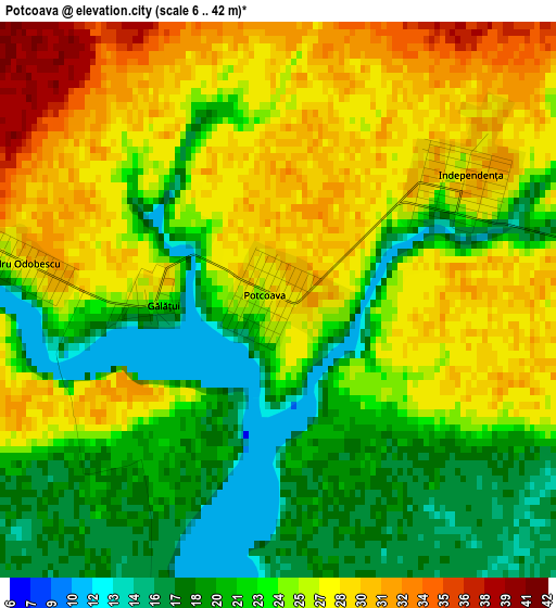
Below is the Elevation map of Potcoava, which displays elevation range with different colors. Scale of the first map is from 6 to 42 m (20 to 138 ft) with average elevation of 24.2 meters (=79 ft) [note 1]
These maps also provides idea of topography and contour of this city, they are displayed at different zoom levels. More info about maps, scale and edge coordinates you can find below images.
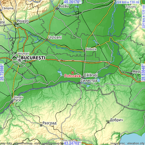
| \ | Map #1 | Topo.Map |
| Scale [m] | 6..42 m | × |
| Scale [ft] | 20..138 ft | × |
| Average | 24.2 m = 79 ft | × |
| Width | 7 km = 4.3 mi | 224 km = 139.2 mi |
| Height | 7 km = 4.3 mi | 223.9 km = 139.1 mi |
| ↑Max Latitude | 44.294783° | 45.26176° |
| Latitude at center | 44.26332° | 44.26332° |
| ↓Min Latitude | 44.231841° | 43.24763° |
| ← Min Longitude | 27.088285° | 25.72598° |
| Longitude center | 27.13223° | 27.13223° |
| →Max Longitude | 27.176175° | 28.53848° |
Nearby cities:
Cities around Potcoava sort by population:
• Grădiştea elevation 10 m
7.5 km,  116°
116°
• Ciocăneşti 19 m
8.8 km,  216°
216°
• Cuza Vodă 19 m
10.7 km,  88°
88°
• Independenţa 29 m
2.6 km,  32°
32°
• Alexandru Odobescu 21 m
3.9 km,  275°
275°
• Vlad Ţepeş 39 m
10.4 km,  338°
338°
• Ceacu 16 m
9.5 km, 88°
• Nicolae Bălcescu 39 m
4.9 km,  300°
300°
• Vâlcelele 42 m
14 km,  5°
5°
• Vărăști 21 m
14 km,  246°
246°
• Rasa 17 m
5.6 km,  167°
167°
• Mihai Viteazu 37 m
10.6 km,  333°
333°
Multilingual:
 En español:
Potcoava elevación 28 m.
 En France:
Potcoava élévation 28 m.


Sources and notes:
- [note 1] Map square and city borders are not equal. Map elevation data is calculated only from area inside that square.
- [src 1] Elevation data from geonames database provided with same terms of usage.
- [src 2] The elevation map of Potcoava is generated using elevation data from NASA's 3 arcsec (90m) resolution SRTM data.
- [src 3] Base (background) map © OpenStreetMap contributors tiles are generated by Geofabrik and OpenTopoMap.
Copyright & License:
This Potcoava Elevation Map is licensed under CC BY-SA. You may reuse any part from this page, if you give a proper credit by linking to this URL:
 More info on terms of use page.