Răchita elevation
Răchita (Timiş, Comuna Dumbrava), Romania elevation is 137 meters and Răchita elevation in feet is 449 ft above sea level [src 1]. Răchita is a populated place (feature code) with elevation that is 115 meters (377 ft) smaller than average city elevation in Romania.
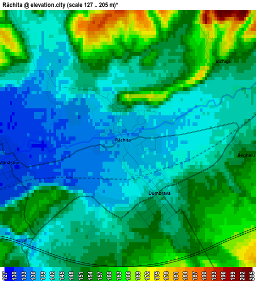
Below is the Elevation map of Răchita, which displays elevation range with different colors. Scale of the first map is from 127 to 205 m (417 to 673 ft) with average elevation of 147.8 meters (=485 ft) [note 1]
These maps also provides idea of topography and contour of this city, they are displayed at different zoom levels. More info about maps, scale and edge coordinates you can find below images.
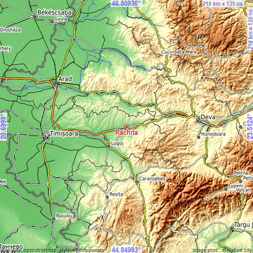
| \ | Map #1 | Topo.Map |
| Scale [m] | 127..205 m | × |
| Scale [ft] | 417..673 ft | × |
| Average | 147.8 m = 485 ft | × |
| Width | 6.81 km = 4.2 mi | 217.9 km = 135.4 mi |
| Height | 6.81 km = 4.2 mi | 217.9 km = 135.4 mi |
| ↑Max Latitude | 45.868878° | 46.80936° |
| Latitude at center | 45.83827° | 45.83827° |
| ↓Min Latitude | 45.807645° | 44.84993° |
| ← Min Longitude | 22.062205° | 20.6999° |
| Longitude center | 22.10615° | 22.10615° |
| →Max Longitude | 22.150095° | 23.5124° |
Nearby cities:
Cities around Răchita sort by population:
• Făget elevation 150 m
6.1 km,  77°
77°
• Bethausen 123 m
11.9 km,  267°
267°
• Dumbrava 150 m
2.5 km,  161°
161°
• Margina 146 m
12.6 km, 79°
• Tomeşti 276 m
16.2 km,  112°
112°
• Traian Vuia 146 m
5.2 km,  215°
215°
• Birchiş 151 m
15 km,  18°
18°
• Fârdea 259 m
12.6 km, 158°
• Mănăştiur 151 m
3.9 km,  231°
231°
• Bârna 213 m
14.2 km,  197°
197°
• Curtea 246 m
15.2 km,  99°
99°
• Ohaba Lungă 154 m
12.1 km,  309°
309°
Multilingual:
 En español:
Răchita elevación 137 m.
 En France:
Răchita élévation 137 m.


Sources and notes:
- [note 1] Map square and city borders are not equal. Map elevation data is calculated only from area inside that square.
- [src 1] Elevation data from geonames database provided with same terms of usage.
- [src 2] The elevation map of Răchita is generated using elevation data from NASA's 3 arcsec (90m) resolution SRTM data.
- [src 3] Base (background) map © OpenStreetMap contributors tiles are generated by Geofabrik and OpenTopoMap.
Copyright & License:
This Răchita Elevation Map is licensed under CC BY-SA. You may reuse any part from this page, if you give a proper credit by linking to this URL:
 More info on terms of use page.