Răchiţi elevation
Răchiţi (Botoşani, Comuna Răchiţi), Romania elevation is 119 meters and Răchiţi elevation in feet is 390 ft above sea level [src 1]. Răchiţi is a seat of a second-order administrative division (feature code) with elevation that is 133 meters (436 ft) smaller than average city elevation in Romania.
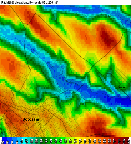
Below is the Elevation map of Răchiţi, which displays elevation range with different colors. Scale of the first map is from 85 to 200 m (279 to 656 ft) with average elevation of 142.7 meters (=468 ft) [note 1]
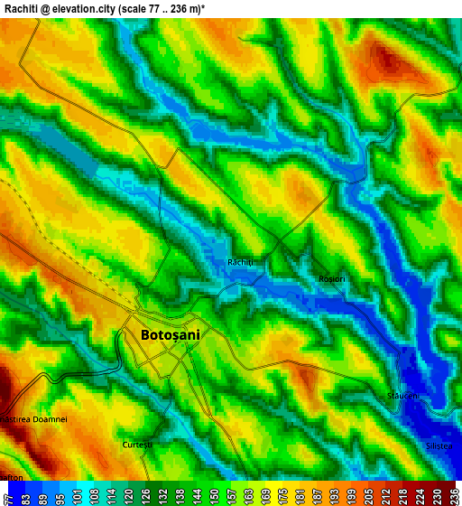
These maps also provides idea of topography and contour of this city, they are displayed at different zoom levels. More info about maps, scale and edge coordinates you can find below images.
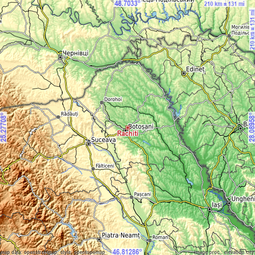
| \ | Map #1 | Map #2 | Topo.Map |
| Scale [m] | 85..200 m | 77..236 m | × |
| Scale [ft] | 279..656 ft | 253..774 ft | × |
| Average | 142.7 m = 468 ft | 147.7 m = 485 ft | × |
| Width | 6.57 km = 4.1 mi | 13.14 km = 8.2 mi | 210.2 km = 130.6 mi |
| Height | 6.57 km = 4.1 mi | 13.14 km = 8.2 mi | 210.2 km = 130.6 mi |
| ↑Max Latitude | 47.7962° | 47.825712° | 48.7033° |
| Latitude at center | 47.76667° | 47.76667° | 47.76667° |
| ↓Min Latitude | 47.737124° | 47.707561° | 46.81286° |
| ← Min Longitude | 26.639385° | 26.595439° | 25.27708° |
| Longitude center | 26.68333° | 26.68333° | 26.68333° |
| →Max Longitude | 26.727275° | 26.771221° | 28.08958° |
Nearby cities:
Cities around Răchiţi sort by population:
• Botoşani elevation 159 m
2.2 km,  213°
213°
• Curteşti 143 m
6.1 km,  204°
204°
• Stăuceni 143 m
7.5 km,  138°
138°
• Roma 128 m
9.7 km,  319°
319°
• Unţeni 107 m
8.3 km,  63°
63°
• Nicşeni 138 m
11.7 km,  341°
341°
• Cătămărești-Deal 200 m
6.3 km,  273°
273°
• Costești 123 m
3.8 km,  351°
351°
• Roșiori 146 m
2.9 km,  102°
102°
• Tocileni 132 m
9.9 km,  128°
128°
• Stâncești 153 m
6.5 km,  253°
253°
• Orășeni-Deal 186 m
10.1 km,  182°
182°
Multilingual:
 En español:
Răchiţi elevación 119 m.
 En France:
Răchiţi élévation 119 m.


Sources and notes:
- [note 1] Map square and city borders are not equal. Map elevation data is calculated only from area inside that square.
- [src 1] Elevation data from geonames database provided with same terms of usage.
- [src 2] The elevation map of Răchiţi is generated using elevation data from NASA's 3 arcsec (90m) resolution SRTM data.
- [src 3] Base (background) map © OpenStreetMap contributors tiles are generated by Geofabrik and OpenTopoMap.
Copyright & License:
This Răchiţi Elevation Map is licensed under CC BY-SA. You may reuse any part from this page, if you give a proper credit by linking to this URL:
 More info on terms of use page.