Rânzești elevation
Rânzești (Vaslui, Comuna Fălciu), Romania elevation is 31 meters and Rânzești elevation in feet is 102 ft above sea level [src 1]. Rânzești is a populated place (feature code) with elevation that is 221 meters (725 ft) smaller than average city elevation in Romania.
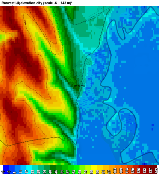
Below is the Elevation map of Rânzești, which displays elevation range with different colors. Scale of the first map is from -6 to 143 m (-20 to 469 ft) with average elevation of 50.2 meters (=165 ft) [note 1]
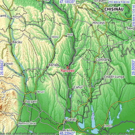
These maps also provides idea of topography and contour of this city, they are displayed at different zoom levels. More info about maps, scale and edge coordinates you can find below images.
| \ | Map #1 | Topo.Map |
| Scale [m] | -6..143 m | × |
| Scale [ft] | -20..469 ft | × |
| Average | 50.2 m = 165 ft | × |
| Width | 6.76 km = 4.2 mi | 216.4 km = 134.5 mi |
| Height | 6.76 km = 4.2 mi | 216.4 km = 134.5 mi |
| ↑Max Latitude | 46.251406° | 47.18535° |
| Latitude at center | 46.22101° | 46.22101° |
| ↓Min Latitude | 46.190597° | 45.23943° |
| ← Min Longitude | 28.050735° | 26.68843° |
| Longitude center | 28.09468° | 28.09468° |
| →Max Longitude | 28.138625° | 29.50093° |
Nearby cities:
Cities around Rânzești sort by population:
• Murgeni elevation 35 m
6.1 km,  252°
252°
• Fălciu 27 m
9.1 km,  23°
23°
• Berezeni 39 m
17.7 km,  13°
13°
• Cavadineşti 86 m
18.2 km,  199°
199°
• Măluşteni 264 m
14.3 km, 252°
• Şuletea 204 m
16.5 km,  294°
294°
• Găgeşti 95 m
15.9 km,  321°
321°
• Blăgeşti 93 m
11.2 km,  213°
213°
• Satu Nou 28 m
15.8 km, 15°
• Cârja 15 m
8.1 km,  171°
171°
• Gănești 69 m
16.6 km, 208°
• Epureni 90 m
14.4 km,  281°
281°
Multilingual:
 En español:
Rânzești elevación 31 m.
 En France:
Rânzești élévation 31 m.


Sources and notes:
- [note 1] Map square and city borders are not equal. Map elevation data is calculated only from area inside that square.
- [src 1] Elevation data from geonames database provided with same terms of usage.
- [src 2] The elevation map of Rânzești is generated using elevation data from NASA's 3 arcsec (90m) resolution SRTM data.
- [src 3] Base (background) map © OpenStreetMap contributors tiles are generated by Geofabrik and OpenTopoMap.
Copyright & License:
This Rânzești Elevation Map is licensed under CC BY-SA. You may reuse any part from this page, if you give a proper credit by linking to this URL:
 More info on terms of use page.