Salonta elevation
Salonta (Bihor, Municipiul Salonta), Romania elevation is 92 meters and Salonta elevation in feet is 302 ft above sea level [src 1]. Salonta is a seat of a second-order administrative division (feature code) with elevation that is 160 meters (525 ft) smaller than average city elevation in Romania.
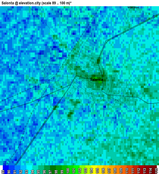
Below is the Elevation map of Salonta, which displays elevation range with different colors. Scale of the first map is from 89 to 100 m (292 to 328 ft) with average elevation of 92.8 meters (=304 ft) [note 1]
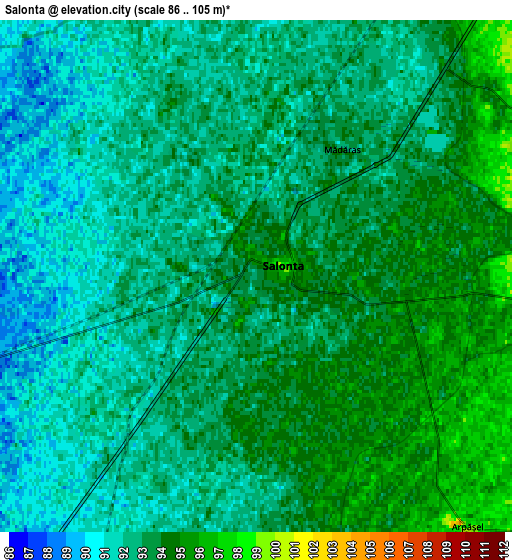
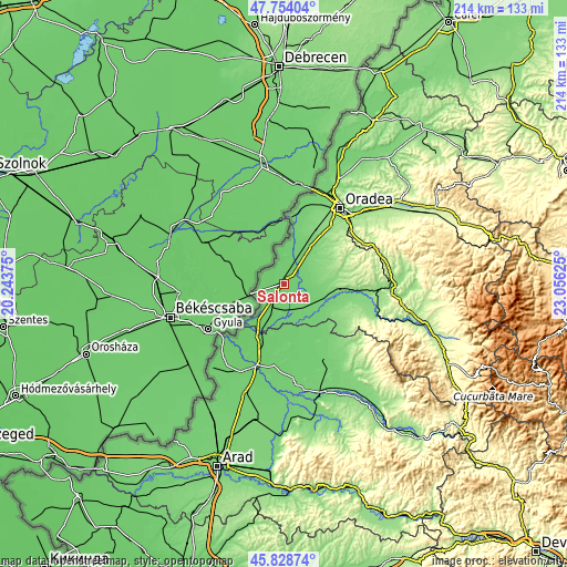
These maps also provides idea of topography and contour of this city, they are displayed at different zoom levels. More info about maps, scale and edge coordinates you can find below images.
| \ | Map #1 | Map #2 | Topo.Map |
| Scale [m] | 89..100 m | 86..105 m | × |
| Scale [ft] | 292..328 ft | 282..344 ft | × |
| Average | 92.8 m = 304 ft | 92.5 m = 303 ft | × |
| Width | 6.69 km = 4.2 mi | 13.38 km = 8.3 mi | 214.1 km = 133 mi |
| Height | 6.69 km = 4.2 mi | 13.38 km = 8.3 mi | 214.1 km = 133 mi |
| ↑Max Latitude | 46.830074° | 46.860132° | 47.75404° |
| Latitude at center | 46.8° | 46.8° | 46.8° |
| ↓Min Latitude | 46.769909° | 46.739801° | 45.82874° |
| ← Min Longitude | 21.606055° | 21.562109° | 20.24375° |
| Longitude center | 21.65° | 21.65° | 21.65° |
| →Max Longitude | 21.693945° | 21.737891° | 23.05625° |
Nearby cities:
Cities around Salonta sort by population:
• Cefa elevation 101 m
14.4 km,  26°
26°
• Batăr 100 m
16.9 km,  131°
131°
• Ciumeghiu 91 m
9 km,  214°
214°
• Mădăraş 93 m
4.5 km, 34°
• Tulca 108 m
10.3 km,  100°
100°
• Ghiorac 96 m
10 km,  165°
165°
• Talpoș 102 m
16.8 km,  135°
135°
• Gurbediu 118 m
16.4 km,  92°
92°
• Ianoșda 117 m
12.7 km,  70°
70°
• Gepiu 108 m
18 km,  36°
36°
• Tăut 105 m
16.9 km,  121°
121°
• Avram Iancu 89 m
17.4 km, 213°
Multilingual:
 En español:
Salonta elevación 92 m.
 En France:
Salonta élévation 92 m.


Sources and notes:
- [note 1] Map square and city borders are not equal. Map elevation data is calculated only from area inside that square.
- [src 1] Elevation data from geonames database provided with same terms of usage.
- [src 2] The elevation map of Salonta is generated using elevation data from NASA's 3 arcsec (90m) resolution SRTM data.
- [src 3] Base (background) map © OpenStreetMap contributors tiles are generated by Geofabrik and OpenTopoMap.
Copyright & License:
This Salonta Elevation Map is licensed under CC BY-SA. You may reuse any part from this page, if you give a proper credit by linking to this URL:
 More info on terms of use page.