Săvădisla elevation
Săvădisla (Cluj, Comuna Săvădisla), Romania elevation is 551 meters and Săvădisla elevation in feet is 1808 ft above sea level [src 1]. Săvădisla is a seat of a second-order administrative division (feature code) with elevation that is 299 meters (981 ft) bigger than average city elevation in Romania.
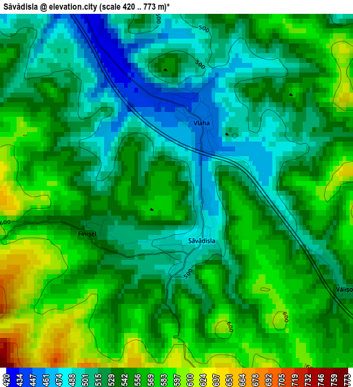
Below is the Elevation map of Săvădisla, which displays elevation range with different colors. Scale of the first map is from 420 to 773 m (1378 to 2536 ft) with average elevation of 540.4 meters (=1773 ft) [note 1]
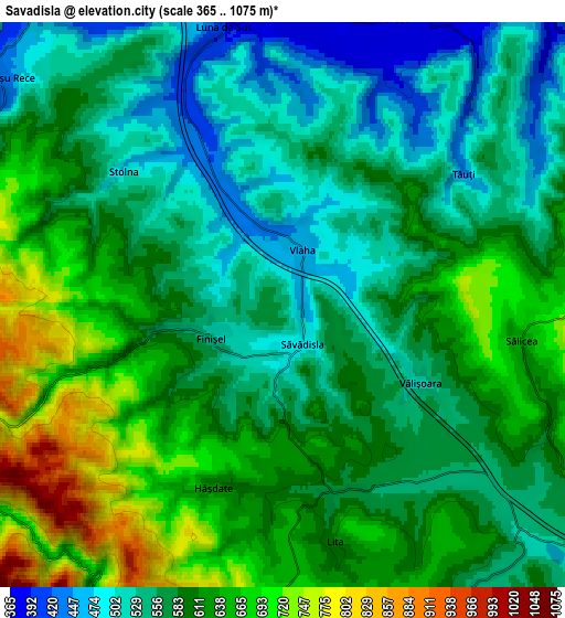
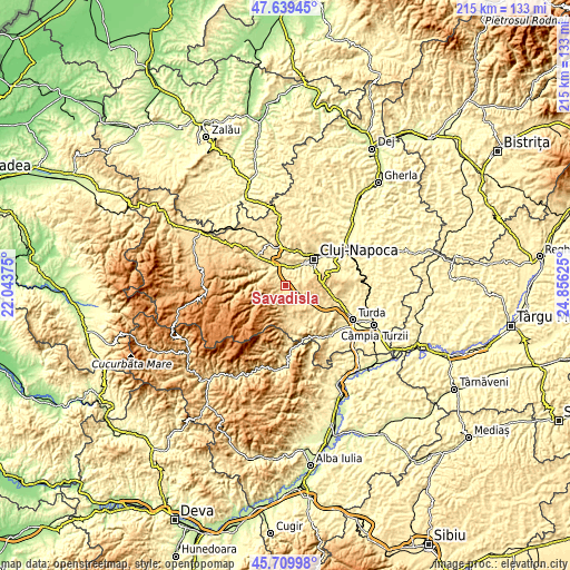
These maps also provides idea of topography and contour of this city, they are displayed at different zoom levels. More info about maps, scale and edge coordinates you can find below images.
| \ | Map #1 | Map #2 | Topo.Map |
| Scale [m] | 420..773 m | 365..1075 m | × |
| Scale [ft] | 1378..2536 ft | 1198..3527 ft | × |
| Average | 540.4 m = 1773 ft | 591.1 m = 1939 ft | × |
| Width | 6.7 km = 4.2 mi | 13.41 km = 8.3 mi | 214.5 km = 133.3 mi |
| Height | 6.7 km = 4.2 mi | 13.41 km = 8.3 mi | 214.5 km = 133.3 mi |
| ↑Max Latitude | 46.713469° | 46.743592° | 47.63945° |
| Latitude at center | 46.68333° | 46.68333° | 46.68333° |
| ↓Min Latitude | 46.653174° | 46.623001° | 45.70998° |
| ← Min Longitude | 23.406055° | 23.362109° | 22.04375° |
| Longitude center | 23.45° | 23.45° | 23.45° |
| →Max Longitude | 23.493945° | 23.537891° | 24.85625° |
Nearby cities:
Cities around Săvădisla sort by population:
• Cluj-Napoca elevation 352 m
14.7 km,  50°
50°
• Baciu 395 m
13.9 km,  21°
21°
• Gilău 424 m
8.7 km,  309°
309°
• Floreşti 366 m
7.7 km,  25°
25°
• Iara 454 m
15.7 km,  161°
161°
• Feleacu 690 m
13.2 km,  73°
73°
• Băişoara 545 m
11.2 km,  173°
173°
• Luna de Sus 393 m
6.7 km,  350°
350°
• Ciurila 652 m
8.5 km,  115°
115°
• Mera 408 m
14.7 km,  1°
1°
• Suceagu 418 m
11.3 km,  5°
5°
• Valea Ierii 864 m
8.5 km,  244°
244°
Multilingual:
 En español:
Săvădisla elevación 551 m.
 En France:
Săvădisla élévation 551 m.
 Auf Deutsch:
Săvădisla höhe über dem Meeresspiegel ist 551 m.

Sources and notes:
- [note 1] Map square and city borders are not equal. Map elevation data is calculated only from area inside that square.
- [src 1] Elevation data from geonames database provided with same terms of usage.
- [src 2] The elevation map of Săvădisla is generated using elevation data from NASA's 3 arcsec (90m) resolution SRTM data.
- [src 3] Base (background) map © OpenStreetMap contributors tiles are generated by Geofabrik and OpenTopoMap.
Copyright & License:
This Săvădisla Elevation Map is licensed under CC BY-SA. You may reuse any part from this page, if you give a proper credit by linking to this URL:
 More info on terms of use page.