Şieu-Odorhei elevation
Şieu-Odorhei (Bistriţa-Năsăud, Comuna Şieu-Odorhei), Romania elevation is 280 meters and Şieu-Odorhei elevation in feet is 919 ft above sea level [src 1]. Şieu-Odorhei is a seat of a second-order administrative division (feature code) with elevation that is 28 meters (92 ft) bigger than average city elevation in Romania.
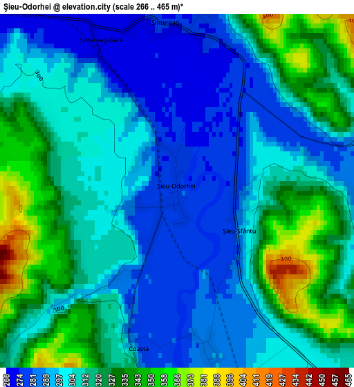
Below is the Elevation map of Şieu-Odorhei, which displays elevation range with different colors. Scale of the first map is from 266 to 465 m (873 to 1526 ft) with average elevation of 308.8 meters (=1013 ft) [note 1]
These maps also provides idea of topography and contour of this city, they are displayed at different zoom levels. More info about maps, scale and edge coordinates you can find below images.
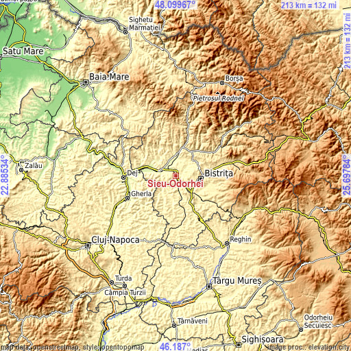
| \ | Map #1 | Topo.Map |
| Scale [m] | 266..465 m | × |
| Scale [ft] | 873..1526 ft | × |
| Average | 308.8 m = 1013 ft | × |
| Width | 6.65 km = 4.1 mi | 212.7 km = 132.2 mi |
| Height | 6.65 km = 4.1 mi | 212.7 km = 132.2 mi |
| ↑Max Latitude | 47.181817° | 48.09967° |
| Latitude at center | 47.15194° | 47.15194° |
| ↓Min Latitude | 47.122046° | 46.187° |
| ← Min Longitude | 24.247645° | 22.88534° |
| Longitude center | 24.29159° | 24.29159° |
| →Max Longitude | 24.335535° | 25.69784° |
Nearby cities:
Cities around Şieu-Odorhei sort by population:
• Beclean elevation 257 m
8.9 km,  293°
293°
• Lechinţa 344 m
15.7 km,  163°
163°
• Nimigea de Sus 332 m
14.7 km,  7°
7°
• Căianu Mic 276 m
14 km,  310°
310°
• Şieu-Măgheruş 307 m
10.3 km,  137°
137°
• Şintereag 282 m
3.5 km, 10°
• Nuşeni 294 m
9 km,  230°
230°
• Chiuza 272 m
9.6 km,  340°
340°
• Nimigea de Jos 286 m
11.3 km,  3°
3°
• Cociu 270 m
6.9 km,  319°
319°
• Cristeștii Ciceului 248 m
15.5 km, 287°
• Viișoara 337 m
13.1 km,  114°
114°
Multilingual:
 En español:
Şieu-Odorhei elevación 280 m.
 En France:
Şieu-Odorhei élévation 280 m.
 Auf Deutsch:
Şieu-Odorhei höhe über dem Meeresspiegel ist 280 m.

Sources and notes:
- [note 1] Map square and city borders are not equal. Map elevation data is calculated only from area inside that square.
- [src 1] Elevation data from geonames database provided with same terms of usage.
- [src 2] The elevation map of Şieu-Odorhei is generated using elevation data from NASA's 3 arcsec (90m) resolution SRTM data.
- [src 3] Base (background) map © OpenStreetMap contributors tiles are generated by Geofabrik and OpenTopoMap.
Copyright & License:
This Şieu-Odorhei Elevation Map is licensed under CC BY-SA. You may reuse any part from this page, if you give a proper credit by linking to this URL:
 More info on terms of use page.