Siliştea elevation
Siliştea (Constanța, Comuna Siliştea), Romania elevation is 48 meters and Siliştea elevation in feet is 157 ft above sea level [src 1]. Siliştea is a seat of a second-order administrative division (feature code) with elevation that is 204 meters (669 ft) smaller than average city elevation in Romania.
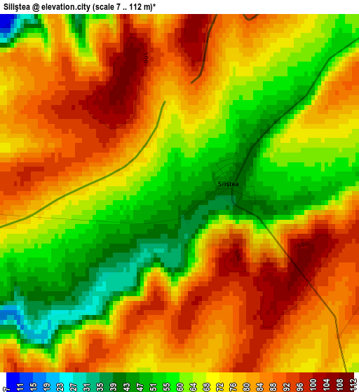
Below is the Elevation map of Siliştea, which displays elevation range with different colors. Scale of the first map is from 7 to 112 m (23 to 367 ft) with average elevation of 72.4 meters (=238 ft) [note 1]
These maps also provides idea of topography and contour of this city, they are displayed at different zoom levels. More info about maps, scale and edge coordinates you can find below images.
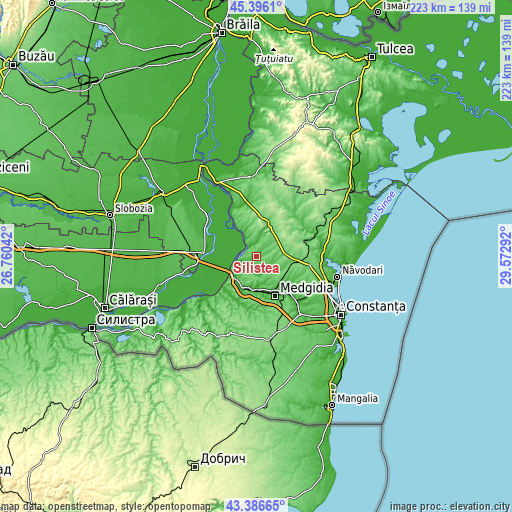
| \ | Map #1 | Topo.Map |
| Scale [m] | 7..112 m | × |
| Scale [ft] | 23..367 ft | × |
| Average | 72.4 m = 238 ft | × |
| Width | 6.98 km = 4.3 mi | 223.4 km = 138.8 mi |
| Height | 6.98 km = 4.3 mi | 223.4 km = 138.8 mi |
| ↑Max Latitude | 44.431389° | 45.3961° |
| Latitude at center | 44.4° | 44.4° |
| ↓Min Latitude | 44.368594° | 43.38665° |
| ← Min Longitude | 28.122725° | 26.76042° |
| Longitude center | 28.16667° | 28.16667° |
| →Max Longitude | 28.210615° | 29.57292° |
Nearby cities:
Cities around Siliştea sort by population:
• Cernavodă elevation 15 m
12.6 km,  237°
237°
• Mircea Vodă 45 m
13 km,  180°
180°
• Nicolae Bălcescu 79 m
17.3 km,  96°
96°
• Crucea 90 m
15.7 km,  19°
19°
• Cuza Vodă 19 m
16.9 km,  137°
137°
• Satu Nou 27 m
15.3 km,  162°
162°
• Seimeni 53 m
8.2 km,  256°
256°
• Topalu 41 m
18.6 km,  329°
329°
• Tortoman 40 m
6.8 km, 144°
• Dorobanțu 87 m
12.8 km,  84°
84°
• Făclia 32 m
14.2 km,  199°
199°
• Saligny 38 m
14.5 km, 204°
Multilingual:
 En español:
Siliştea elevación 48 m.
 En France:
Siliştea élévation 48 m.


Sources and notes:
- [note 1] Map square and city borders are not equal. Map elevation data is calculated only from area inside that square.
- [src 1] Elevation data from geonames database provided with same terms of usage.
- [src 2] The elevation map of Siliştea is generated using elevation data from NASA's 3 arcsec (90m) resolution SRTM data.
- [src 3] Base (background) map © OpenStreetMap contributors tiles are generated by Geofabrik and OpenTopoMap.
Copyright & License:
This Siliştea Elevation Map is licensed under CC BY-SA. You may reuse any part from this page, if you give a proper credit by linking to this URL:
 More info on terms of use page.