Sânmărtin elevation
Sânmărtin (Cluj, Comuna Sânmărtin), Romania elevation is 312 meters and Sânmărtin elevation in feet is 1024 ft above sea level [src 1]. Sânmărtin is a seat of a second-order administrative division (feature code) with elevation that is 60 meters (197 ft) bigger than average city elevation in Romania.
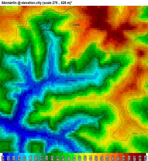
Below is the Elevation map of Sânmărtin, which displays elevation range with different colors. Scale of the first map is from 279 to 628 m (915 to 2060 ft) with average elevation of 433.9 meters (=1424 ft) [note 1]
These maps also provides idea of topography and contour of this city, they are displayed at different zoom levels. More info about maps, scale and edge coordinates you can find below images.
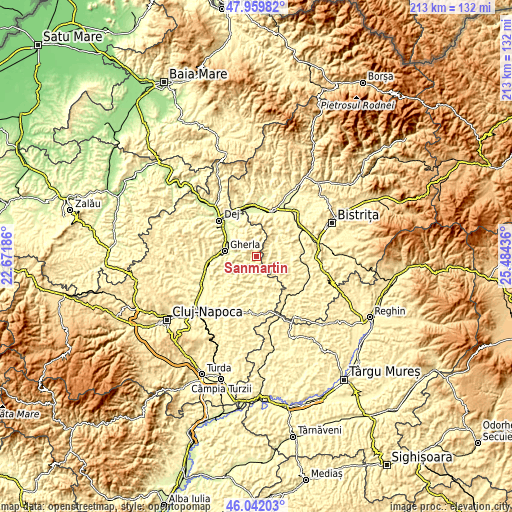
| \ | Map #1 | Topo.Map |
| Scale [m] | 279..628 m | × |
| Scale [ft] | 915..2060 ft | × |
| Average | 433.9 m = 1424 ft | × |
| Width | 6.66 km = 4.1 mi | 213.2 km = 132.5 mi |
| Height | 6.66 km = 4.1 mi | 213.2 km = 132.5 mi |
| ↑Max Latitude | 47.039487° | 47.95982° |
| Latitude at center | 47.00953° | 47.00953° |
| ↓Min Latitude | 46.979556° | 46.04203° |
| ← Min Longitude | 24.034165° | 22.67186° |
| Longitude center | 24.07811° | 24.07811° |
| →Max Longitude | 24.122055° | 25.48436° |
Nearby cities:
Cities around Sânmărtin sort by population:
• Gherla elevation 250 m
12.5 km,  282°
282°
• Mintiu Gherlii 378 m
10.7 km,  294°
294°
• Chiochiş 339 m
8.5 km,  110°
110°
• Nuşeni 294 m
13.7 km,  42°
42°
• Unguraş 310 m
12.1 km,  349°
349°
• Matei 326 m
14.6 km,  101°
101°
• Fizeşu Gherlii 357 m
7.2 km, 276°
• Ţaga 280 m
7 km,  197°
197°
• Cireșoaia 460 m
14.9 km,  355°
355°
• Geaca 398 m
16 km,  174°
174°
• Buza 452 m
13.3 km,  155°
155°
• Nireș 256 m
13.8 km,  327°
327°
Multilingual:
 En español:
Sânmărtin elevación 312 m.
 En France:
Sânmărtin élévation 312 m.
 Auf Deutsch:
Sânmărtin höhe über dem Meeresspiegel ist 312 m.

Sources and notes:
- [note 1] Map square and city borders are not equal. Map elevation data is calculated only from area inside that square.
- [src 1] Elevation data from geonames database provided with same terms of usage.
- [src 2] The elevation map of Sânmărtin is generated using elevation data from NASA's 3 arcsec (90m) resolution SRTM data.
- [src 3] Base (background) map © OpenStreetMap contributors tiles are generated by Geofabrik and OpenTopoMap.
Copyright & License:
This Sânmărtin Elevation Map is licensed under CC BY-SA. You may reuse any part from this page, if you give a proper credit by linking to this URL:
 More info on terms of use page.