Straja elevation
Straja (Suceava, Comuna Straja), Romania elevation is 512 meters and Straja elevation in feet is 1680 ft above sea level [src 1]. Straja is a seat of a second-order administrative division (feature code) with elevation that is 260 meters (853 ft) bigger than average city elevation in Romania.
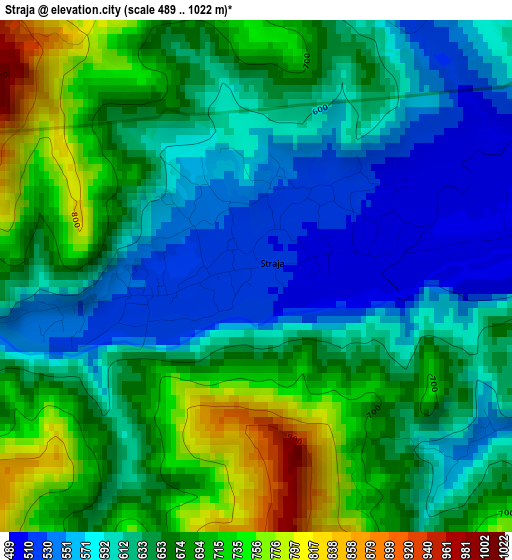
Below is the Elevation map of Straja, which displays elevation range with different colors. Scale of the first map is from 489 to 1022 m (1604 to 3353 ft) with average elevation of 641.6 meters (=2105 ft) [note 1]
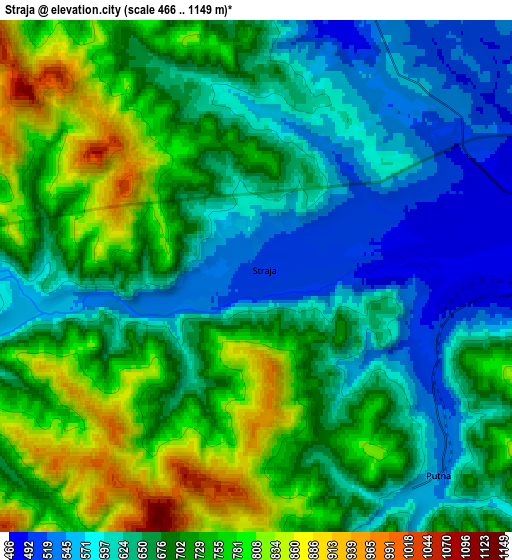
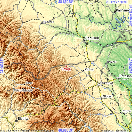
These maps also provides idea of topography and contour of this city, they are displayed at different zoom levels. More info about maps, scale and edge coordinates you can find below images.
| \ | Map #1 | Map #2 | Topo.Map |
| Scale [m] | 489..1022 m | 466..1149 m | × |
| Scale [ft] | 1604..3353 ft | 1529..3770 ft | × |
| Average | 641.6 m = 2105 ft | 681.3 m = 2235 ft | × |
| Width | 6.55 km = 4.1 mi | 13.1 km = 8.1 mi | 209.6 km = 130.2 mi |
| Height | 6.55 km = 4.1 mi | 13.1 km = 8.1 mi | 209.6 km = 130.2 mi |
| ↑Max Latitude | 47.946114° | 47.975542° | 48.85058° |
| Latitude at center | 47.91667° | 47.91667° | 47.91667° |
| ↓Min Latitude | 47.887209° | 47.857731° | 46.96559° |
| ← Min Longitude | 25.506055° | 25.462109° | 24.14375° |
| Longitude center | 25.55° | 25.55° | 25.55° |
| →Max Longitude | 25.593945° | 25.637891° | 26.95625° |
Nearby cities:
Cities around Straja sort by population:
• Vicovu de Sus elevation 460 m
10.1 km,  79°
79°
• Gălăneşti 405 m
18.6 km,  90°
90°
• Vicovu de Jos 438 m
13.8 km,  97°
97°
• Putna 603 m
7.5 km,  138°
138°
• Brodina 594 m
10.6 km,  249°
249°
• Bilca 422 m
14.9 km, 90°
• Voitinel 454 m
15.9 km, 103°
• Bivolărie 463 m
7.8 km, 91°
• Ulma 685 m
19 km,  258°
258°
• Gura Putnei 522 m
3.9 km,  119°
119°
• Falcău 565 m
6.1 km, 263°
• Argel 746 m
18.3 km,  198°
198°
Multilingual:
 En español:
Straja elevación 512 m.
 En France:
Straja élévation 512 m.


Sources and notes:
- [note 1] Map square and city borders are not equal. Map elevation data is calculated only from area inside that square.
- [src 1] Elevation data from geonames database provided with same terms of usage.
- [src 2] The elevation map of Straja is generated using elevation data from NASA's 3 arcsec (90m) resolution SRTM data.
- [src 3] Base (background) map © OpenStreetMap contributors tiles are generated by Geofabrik and OpenTopoMap.
Copyright & License:
This Straja Elevation Map is licensed under CC BY-SA. You may reuse any part from this page, if you give a proper credit by linking to this URL:
 More info on terms of use page.