Şugag elevation
Şugag (Alba, Comuna Şugag), Romania elevation is 633 meters and Şugag elevation in feet is 2077 ft above sea level [src 1]. Şugag is a seat of a second-order administrative division (feature code) with elevation that is 381 meters (1250 ft) bigger than average city elevation in Romania.
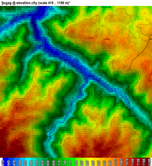
Below is the Elevation map of Şugag, which displays elevation range with different colors. Scale of the first map is from 419 to 1196 m (1375 to 3924 ft) with average elevation of 807.2 meters (=2648 ft) [note 1]
These maps also provides idea of topography and contour of this city, they are displayed at different zoom levels. More info about maps, scale and edge coordinates you can find below images.
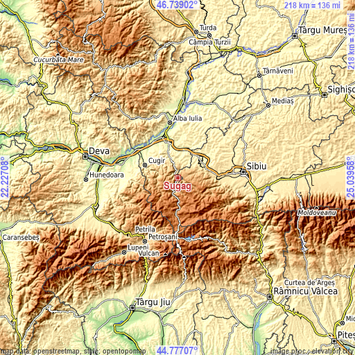
| \ | Map #1 | Topo.Map |
| Scale [m] | 419..1196 m | × |
| Scale [ft] | 1375..3924 ft | × |
| Average | 807.2 m = 2648 ft | × |
| Width | 6.82 km = 4.2 mi | 218.1 km = 135.5 mi |
| Height | 6.82 km = 4.2 mi | 218.1 km = 135.5 mi |
| ↑Max Latitude | 45.797317° | 46.73902° |
| Latitude at center | 45.76667° | 45.76667° |
| ↓Min Latitude | 45.736006° | 44.77707° |
| ← Min Longitude | 23.589385° | 22.22708° |
| Longitude center | 23.63333° | 23.63333° |
| →Max Longitude | 23.677275° | 25.03958° |
Nearby cities:
Cities around Şugag sort by population:
• Săsciori elevation 460 m
11.8 km,  340°
340°
• Petrești 275 m
18.1 km, 341°
• Jina 948 m
4.3 km,  64°
64°
• Miercurea Sibiului 326 m
18.3 km,  44°
44°
• Pianu de Sus 309 m
18.8 km,  321°
321°
• Câlnic 367 m
13.2 km,  11°
11°
• Poiana Sibiului 982 m
8.6 km, 64°
• Gârbova 355 m
13.6 km,  34°
34°
• Tilişca 584 m
17.2 km,  77°
77°
• Cut 290 m
19.4 km, 7°
• Dobra 496 m
0.7 km,  68°
68°
• Sebeșel 304 m
14.4 km, 338°
Multilingual:
 En español:
Şugag elevación 633 m.
 En France:
Şugag élévation 633 m.


Sources and notes:
- [note 1] Map square and city borders are not equal. Map elevation data is calculated only from area inside that square.
- [src 1] Elevation data from geonames database provided with same terms of usage.
- [src 2] The elevation map of Şugag is generated using elevation data from NASA's 3 arcsec (90m) resolution SRTM data.
- [src 3] Base (background) map © OpenStreetMap contributors tiles are generated by Geofabrik and OpenTopoMap.
Copyright & License:
This Şugag Elevation Map is licensed under CC BY-SA. You may reuse any part from this page, if you give a proper credit by linking to this URL:
 More info on terms of use page.