Suhaia elevation
Suhaia (Teleorman, Comuna Suhaia), Romania elevation is 21 meters and Suhaia elevation in feet is 69 ft above sea level [src 1]. Suhaia is a seat of a second-order administrative division (feature code) with elevation that is 231 meters (758 ft) smaller than average city elevation in Romania.
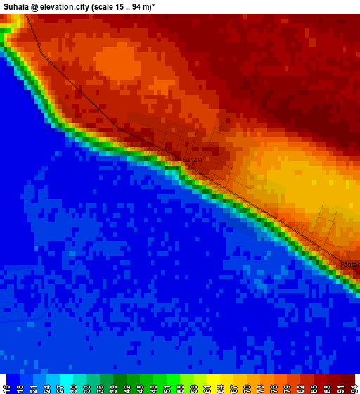
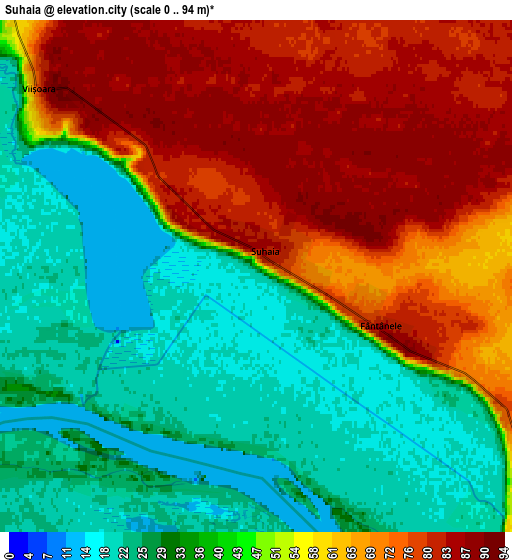
Below is the Elevation map of Suhaia, which displays elevation range with different colors. Scale of the first map is from 15 to 94 m (49 to 308 ft) with average elevation of 47.3 meters (=155 ft) [note 1]
These maps also provides idea of topography and contour of this city, they are displayed at different zoom levels. More info about maps, scale and edge coordinates you can find below images.
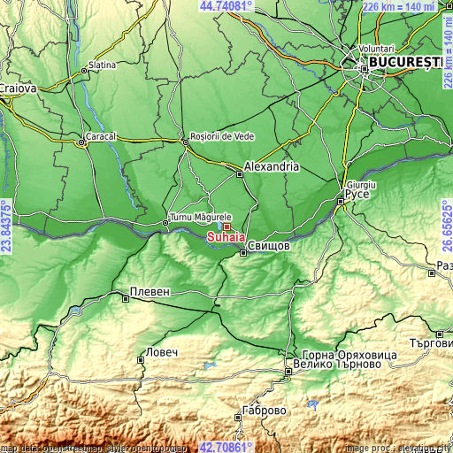
| \ | Map #1 | Map #2 | Topo.Map |
| Scale [m] | 15..94 m | 0..94 m | × |
| Scale [ft] | 49..308 ft | 0..308 ft | × |
| Average | 47.3 m = 155 ft | 48.8 m = 160 ft | × |
| Width | 7.06 km = 4.4 mi | 14.12 km = 8.8 mi | 226 km = 140.4 mi |
| Height | 7.06 km = 4.4 mi | 14.12 km = 8.8 mi | 226 km = 140.4 mi |
| ↑Max Latitude | 43.765075° | 43.796803° | 44.74081° |
| Latitude at center | 43.73333° | 43.73333° | 43.73333° |
| ↓Min Latitude | 43.701568° | 43.66979° | 42.70861° |
| ← Min Longitude | 25.206055° | 25.162109° | 23.84375° |
| Longitude center | 25.25° | 25.25° | 25.25° |
| →Max Longitude | 25.293945° | 25.337891° | 26.65625° |
Nearby cities:
Cities around Suhaia sort by population:
• Zimnicea elevation 26 m
12.6 km,  132°
132°
• Piatra 44 m
11.4 km,  324°
324°
• Năsturelu 20 m
18.9 km,  113°
113°
• Seaca 29 m
14.8 km,  277°
277°
• Frumoasa 50 m
18.9 km,  66°
66°
• Izvoarele 81 m
14.2 km,  49°
49°
• Lisa 81 m
11.9 km,  308°
308°
• Fântânele 84 m
3.7 km, 111°
• Viişoara 20 m
8.7 km, 309°
• Furculești 38 m
17.7 km,  330°
330°
• Zimnicele 30 m
15.4 km,  121°
121°
• Năvodari 43 m
12.6 km,  274°
274°
Multilingual:
 En español:
Suhaia elevación 21 m.
 En France:
Suhaia élévation 21 m.


Sources and notes:
- [note 1] Map square and city borders are not equal. Map elevation data is calculated only from area inside that square.
- [src 1] Elevation data from geonames database provided with same terms of usage.
- [src 2] The elevation map of Suhaia is generated using elevation data from NASA's 3 arcsec (90m) resolution SRTM data.
- [src 3] Base (background) map © OpenStreetMap contributors tiles are generated by Geofabrik and OpenTopoMap.
Copyright & License:
This Suhaia Elevation Map is licensed under CC BY-SA. You may reuse any part from this page, if you give a proper credit by linking to this URL:
 More info on terms of use page.