Tălmăcel elevation
Tălmăcel (Sibiu, Oraş Tãlmaciu), Romania elevation is 434 meters and Tălmăcel elevation in feet is 1424 ft above sea level [src 1]. Tălmăcel is a populated place (feature code) with elevation that is 182 meters (597 ft) bigger than average city elevation in Romania.
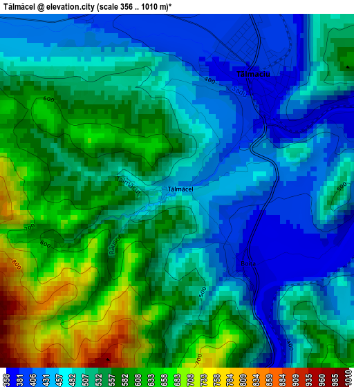
Below is the Elevation map of Tălmăcel, which displays elevation range with different colors. Scale of the first map is from 356 to 1010 m (1168 to 3314 ft) with average elevation of 524.4 meters (=1720 ft) [note 1]
These maps also provides idea of topography and contour of this city, they are displayed at different zoom levels. More info about maps, scale and edge coordinates you can find below images.
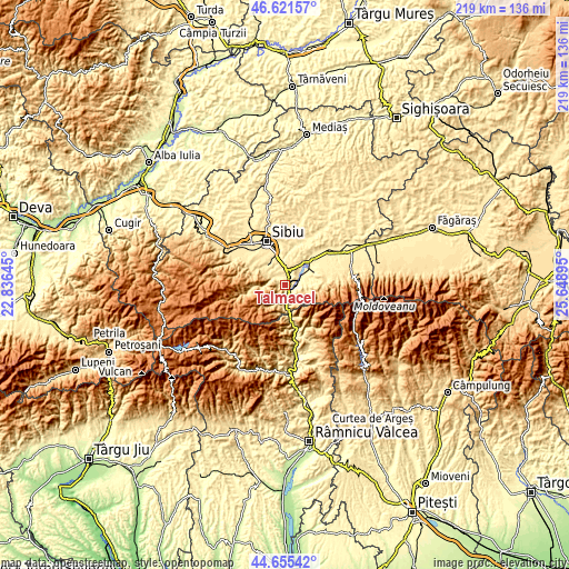
| \ | Map #1 | Topo.Map |
| Scale [m] | 356..1010 m | × |
| Scale [ft] | 1168..3314 ft | × |
| Average | 524.4 m = 1720 ft | × |
| Width | 6.83 km = 4.2 mi | 218.6 km = 135.8 mi |
| Height | 6.83 km = 4.2 mi | 218.6 km = 135.8 mi |
| ↑Max Latitude | 45.677833° | 46.62157° |
| Latitude at center | 45.64712° | 45.64712° |
| ↓Min Latitude | 45.61639° | 44.65542° |
| ← Min Longitude | 24.198755° | 22.83645° |
| Longitude center | 24.2427° | 24.2427° |
| →Max Longitude | 24.286645° | 25.64895° |
Nearby cities:
Cities around Tălmăcel sort by population:
• Cisnădie elevation 455 m
10.6 km,  317°
317°
• Avrig 385 m
13.4 km,  54°
54°
• Tălmaciu 382 m
2.8 km,  37°
37°
• Şelimbăr 403 m
13.7 km,  345°
345°
• Mârșa 382 m
11.5 km,  59°
59°
• Racoviţa 384 m
9.3 km, 64°
• Turnu Roşu 578 m
4.7 km,  108°
108°
• Sadu 565 m
5.1 km,  295°
295°
• Veștem 383 m
7.8 km,  358°
358°
• Boița 374 m
2 km,  135°
135°
• Bradu 382 m
10.9 km, 39°
• Râu Sadului 855 m
14.1 km,  256°
256°
Multilingual:
 En español:
Tălmăcel elevación 434 m.
 En France:
Tălmăcel élévation 434 m.
 Auf Deutsch:
Tălmăcel höhe über dem Meeresspiegel ist 434 m.

Sources and notes:
- [note 1] Map square and city borders are not equal. Map elevation data is calculated only from area inside that square.
- [src 1] Elevation data from geonames database provided with same terms of usage.
- [src 2] The elevation map of Tălmăcel is generated using elevation data from NASA's 3 arcsec (90m) resolution SRTM data.
- [src 3] Base (background) map © OpenStreetMap contributors tiles are generated by Geofabrik and OpenTopoMap.
Copyright & License:
This Tălmăcel Elevation Map is licensed under CC BY-SA. You may reuse any part from this page, if you give a proper credit by linking to this URL:
 More info on terms of use page.