Tătăranu elevation
Tătăranu (Vrancea, Comuna Tãtãranu), Romania elevation is 28 meters and Tătăranu elevation in feet is 92 ft above sea level [src 1]. Tătăranu is a seat of a second-order administrative division (feature code) with elevation that is 224 meters (735 ft) smaller than average city elevation in Romania.
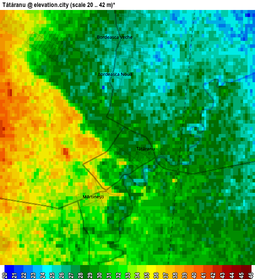
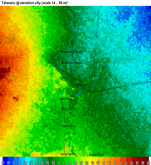
Below is the Elevation map of Tătăranu, which displays elevation range with different colors. Scale of the first map is from 20 to 42 m (66 to 138 ft) with average elevation of 29.8 meters (=98 ft) [note 1]
These maps also provides idea of topography and contour of this city, they are displayed at different zoom levels. More info about maps, scale and edge coordinates you can find below images.
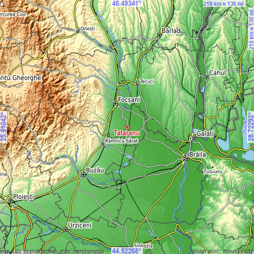
| \ | Map #1 | Map #2 | Topo.Map |
| Scale [m] | 20..42 m | 14..58 m | × |
| Scale [ft] | 66..138 ft | 46..190 ft | × |
| Average | 29.8 m = 98 ft | 31.4 m = 103 ft | × |
| Width | 6.85 km = 4.3 mi | 13.7 km = 8.5 mi | 219.1 km = 136.1 mi |
| Height | 6.85 km = 4.3 mi | 13.7 km = 8.5 mi | 219.1 km = 136.1 mi |
| ↑Max Latitude | 45.547454° | 45.578221° | 46.49341° |
| Latitude at center | 45.51667° | 45.51667° | 45.51667° |
| ↓Min Latitude | 45.485869° | 45.455051° | 44.52268° |
| ← Min Longitude | 27.272725° | 27.228779° | 25.91042° |
| Longitude center | 27.31667° | 27.31667° | 27.31667° |
| →Max Longitude | 27.360615° | 27.404561° | 28.72292° |
Nearby cities:
Cities around Tătăranu sort by population:
• Măicăneşti elevation 14 m
14.4 km,  97°
97°
• Ciorăşti 38 m
9.4 km,  187°
187°
• Gologanu 34 m
10.9 km,  341°
341°
• Vulturu 20 m
13.6 km,  34°
34°
• Băleşti 48 m
11.3 km,  215°
215°
• Slobozia-Ciorăşti 48 m
14.4 km,  320°
320°
• Bordeasca Veche 26 m
3.1 km,  0°
0°
• Râmniceni 18 m
10.3 km,  92°
92°
• Puieștii de Jos 60 m
14.7 km,  210°
210°
• Bogza 62 m
9.3 km,  264°
264°
• Dăscălești 52 m
13.3 km,  202°
202°
• Mihălceni 42 m
8 km, 186°
Multilingual:
 En español:
Tătăranu elevación 28 m.
 En France:
Tătăranu élévation 28 m.


Sources and notes:
- [note 1] Map square and city borders are not equal. Map elevation data is calculated only from area inside that square.
- [src 1] Elevation data from geonames database provided with same terms of usage.
- [src 2] The elevation map of Tătăranu is generated using elevation data from NASA's 3 arcsec (90m) resolution SRTM data.
- [src 3] Base (background) map © OpenStreetMap contributors tiles are generated by Geofabrik and OpenTopoMap.
Copyright & License:
This Tătăranu Elevation Map is licensed under CC BY-SA. You may reuse any part from this page, if you give a proper credit by linking to this URL:
 More info on terms of use page.