Telcișor elevation
Telcișor (Bistriţa-Năsăud, Comuna Telciu), Romania elevation is 449 meters and Telcișor elevation in feet is 1473 ft above sea level [src 1]. Telcișor is a populated place (feature code) with elevation that is 197 meters (646 ft) bigger than average city elevation in Romania.
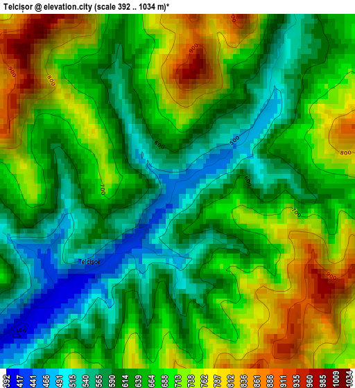
Below is the Elevation map of Telcișor, which displays elevation range with different colors. Scale of the first map is from 392 to 1034 m (1286 to 3392 ft) with average elevation of 662.4 meters (=2173 ft) [note 1]
These maps also provides idea of topography and contour of this city, they are displayed at different zoom levels. More info about maps, scale and edge coordinates you can find below images.
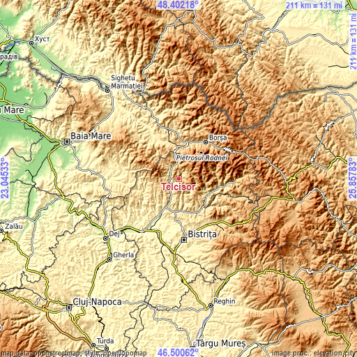
| \ | Map #1 | Topo.Map |
| Scale [m] | 392..1034 m | × |
| Scale [ft] | 1286..3392 ft | × |
| Average | 662.4 m = 2173 ft | × |
| Width | 6.61 km = 4.1 mi | 211.4 km = 131.4 mi |
| Height | 6.61 km = 4.1 mi | 211.4 km = 131.4 mi |
| ↑Max Latitude | 47.489703° | 48.40218° |
| Latitude at center | 47.46° | 47.46° |
| ↓Min Latitude | 47.43028° | 46.50062° |
| ← Min Longitude | 24.407635° | 23.04533° |
| Longitude center | 24.45158° | 24.45158° |
| →Max Longitude | 24.495525° | 25.85783° |
Nearby cities:
Cities around Telcișor sort by population:
• Sângeorz-Băi elevation 434 m
19.5 km,  121°
121°
• Telciu 393 m
4.9 km,  232°
232°
• Salva 300 m
19.4 km,  203°
203°
• Zagra 442 m
18.9 km,  221°
221°
• Săcel 541 m
19.3 km,  355°
355°
• Rebra 423 m
16.3 km,  167°
167°
• Coşbuc 343 m
11.5 km, 203°
• Parva 622 m
10 km,  132°
132°
• Romuli 697 m
8.3 km,  350°
350°
• Runcu Salvei 405 m
16 km, 216°
• Bichigiu 465 m
9.3 km,  245°
245°
• Valea Borcutului 462 m
17.9 km, 122°
Multilingual:
 En español:
Telcișor elevación 449 m.
 En France:
Telcișor élévation 449 m.
 Auf Deutsch:
Telcișor höhe über dem Meeresspiegel ist 449 m.

Sources and notes:
- [note 1] Map square and city borders are not equal. Map elevation data is calculated only from area inside that square.
- [src 1] Elevation data from geonames database provided with same terms of usage.
- [src 2] The elevation map of Telcișor is generated using elevation data from NASA's 3 arcsec (90m) resolution SRTM data.
- [src 3] Base (background) map © OpenStreetMap contributors tiles are generated by Geofabrik and OpenTopoMap.
Copyright & License:
This Telcișor Elevation Map is licensed under CC BY-SA. You may reuse any part from this page, if you give a proper credit by linking to this URL:
 More info on terms of use page.