Ţinteşti elevation
Ţinteşti (Buzău, Comuna Ţinteşti), Romania elevation is 73 meters and Ţinteşti elevation in feet is 240 ft above sea level [src 1]. Ţinteşti is a seat of a second-order administrative division (feature code) with elevation that is 179 meters (587 ft) smaller than average city elevation in Romania.
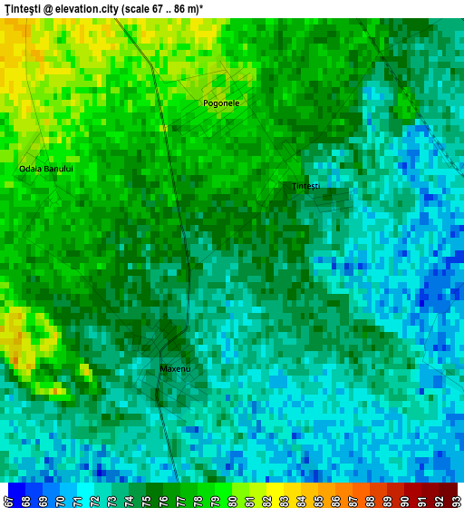
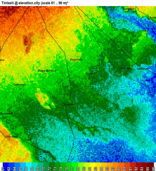
Below is the Elevation map of Ţinteşti, which displays elevation range with different colors. Scale of the first map is from 67 to 86 m (220 to 282 ft) with average elevation of 74.5 meters (=244 ft) [note 1]
These maps also provides idea of topography and contour of this city, they are displayed at different zoom levels. More info about maps, scale and edge coordinates you can find below images.
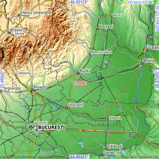
| \ | Map #1 | Map #2 | Topo.Map |
| Scale [m] | 67..86 m | 61..96 m | × |
| Scale [ft] | 220..282 ft | 200..315 ft | × |
| Average | 74.5 m = 244 ft | 74.7 m = 245 ft | × |
| Width | 6.9 km = 4.3 mi | 13.8 km = 8.6 mi | 220.9 km = 137.3 mi |
| Height | 6.9 km = 4.3 mi | 13.8 km = 8.6 mi | 220.9 km = 137.3 mi |
| ↑Max Latitude | 45.097699° | 45.128712° | 46.05125° |
| Latitude at center | 45.06667° | 45.06667° | 45.06667° |
| ↓Min Latitude | 45.035624° | 45.004561° | 44.06483° |
| ← Min Longitude | 26.822725° | 26.778779° | 25.46042° |
| Longitude center | 26.86667° | 26.86667° | 26.86667° |
| →Max Longitude | 26.910615° | 26.954561° | 28.27292° |
Nearby cities:
Cities around Ţinteşti sort by population:
• Buzău elevation 93 m
9.6 km,  344°
344°
• Smeeni 78 m
9.4 km,  188°
188°
• Costeşti 77 m
8.1 km,  256°
256°
• Gălbinaşi 73 m
4.3 km,  64°
64°
• Gherăseni 79 m
7.5 km,  232°
232°
• Scurtești 75 m
8.5 km,  20°
20°
• Maxenu 73 m
1.9 km,  208°
208°
• Tăbărăști 72 m
4.4 km,  71°
71°
• Stăncești 76 m
8 km,  33°
33°
• Pogonele 81 m
2.2 km,  355°
355°
• Pietrosu 82 m
8.6 km, 264°
• Dâmbroca 78 m
9.4 km,  48°
48°
Multilingual:
 En español:
Ţinteşti elevación 73 m.
 En France:
Ţinteşti élévation 73 m.


Sources and notes:
- [note 1] Map square and city borders are not equal. Map elevation data is calculated only from area inside that square.
- [src 1] Elevation data from geonames database provided with same terms of usage.
- [src 2] The elevation map of Ţinteşti is generated using elevation data from NASA's 3 arcsec (90m) resolution SRTM data.
- [src 3] Base (background) map © OpenStreetMap contributors tiles are generated by Geofabrik and OpenTopoMap.
Copyright & License:
This Ţinteşti Elevation Map is licensed under CC BY-SA. You may reuse any part from this page, if you give a proper credit by linking to this URL:
 More info on terms of use page.