Târgu Frumos elevation
Târgu Frumos (Iaşi, Oraş Târgu Frumos), Romania elevation is 104 meters and Târgu Frumos elevation in feet is 341 ft above sea level [src 1]. Târgu Frumos is a seat of a second-order administrative division (feature code) with elevation that is 148 meters (486 ft) smaller than average city elevation in Romania.
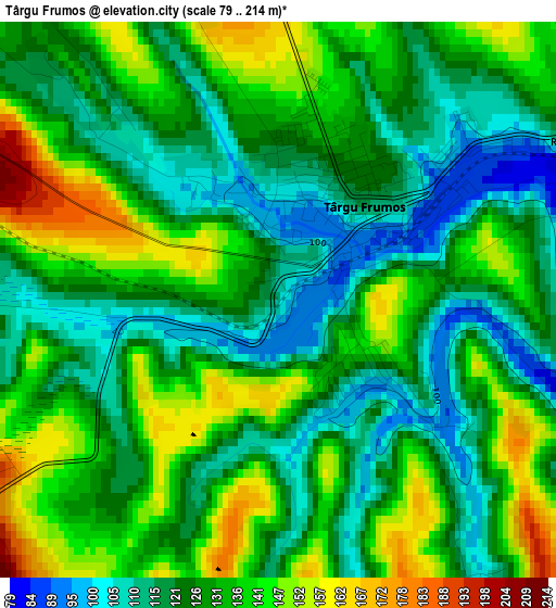
Below is the Elevation map of Târgu Frumos, which displays elevation range with different colors. Scale of the first map is from 79 to 214 m (259 to 702 ft) with average elevation of 128.8 meters (=423 ft) [note 1]
These maps also provides idea of topography and contour of this city, they are displayed at different zoom levels. More info about maps, scale and edge coordinates you can find below images.
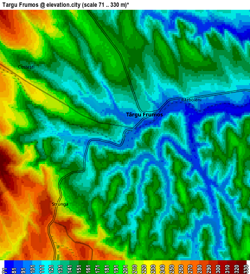
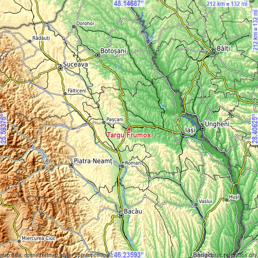
| \ | Map #1 | Map #2 | Topo.Map |
| Scale [m] | 79..214 m | 71..330 m | × |
| Scale [ft] | 259..702 ft | 233..1083 ft | × |
| Average | 128.8 m = 423 ft | 160.8 m = 528 ft | × |
| Width | 6.64 km = 4.1 mi | 13.28 km = 8.3 mi | 212.5 km = 132 mi |
| Height | 6.64 km = 4.1 mi | 13.28 km = 8.3 mi | 212.5 km = 132 mi |
| ↑Max Latitude | 47.22985° | 47.259683° | 48.14687° |
| Latitude at center | 47.2° | 47.2° | 47.2° |
| ↓Min Latitude | 47.170133° | 47.14025° | 46.23593° |
| ← Min Longitude | 26.956055° | 26.912109° | 25.59375° |
| Longitude center | 27° | 27° | 27° |
| →Max Longitude | 27.043945° | 27.087891° | 28.40625° |
Nearby cities:
Cities around Târgu Frumos sort by population:
• Strunga elevation 171 m
3.9 km,  198°
198°
• Brăeşti 102 m
9.4 km,  126°
126°
• Hărmăneasa 275 m
10.1 km,  270°
270°
• Fărcășeni 244 m
9 km,  240°
240°
• Cucuteni 282 m
10.5 km,  331°
331°
• Boureni 134 m
7.4 km,  346°
346°
• Cristești 110 m
7.5 km,  124°
124°
• Buznea 151 m
1.3 km,  114°
114°
• Războieni 106 m
4.3 km,  62°
62°
• Costești 157 m
6.8 km,  304°
304°
• Heleșteni 263 m
9.3 km, 272°
• Ion Neculce 117 m
4 km,  84°
84°
Multilingual:
 En español:
Târgu Frumos elevación 104 m.
 En France:
Târgu Frumos élévation 104 m.
 Auf Deutsch:
Târgu Frumos höhe über dem Meeresspiegel ist 104 m.

Sources and notes:
- [note 1] Map square and city borders are not equal. Map elevation data is calculated only from area inside that square.
- [src 1] Elevation data from geonames database provided with same terms of usage.
- [src 2] The elevation map of Târgu Frumos is generated using elevation data from NASA's 3 arcsec (90m) resolution SRTM data.
- [src 3] Base (background) map © OpenStreetMap contributors tiles are generated by Geofabrik and OpenTopoMap.
Copyright & License:
This Târgu Frumos Elevation Map is licensed under CC BY-SA. You may reuse any part from this page, if you give a proper credit by linking to this URL:
 More info on terms of use page.