Ulmu elevation
Ulmu (Brăila, Comuna Ulmu), Romania elevation is 43 meters and Ulmu elevation in feet is 141 ft above sea level [src 1]. Ulmu is a seat of a second-order administrative division (feature code) with elevation that is 209 meters (686 ft) smaller than average city elevation in Romania.
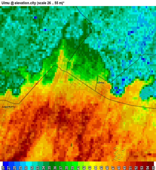
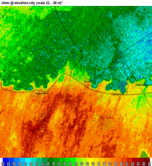
Below is the Elevation map of Ulmu, which displays elevation range with different colors. Scale of the first map is from 26 to 55 m (85 to 180 ft) with average elevation of 40.6 meters (=133 ft) [note 1]
These maps also provides idea of topography and contour of this city, they are displayed at different zoom levels. More info about maps, scale and edge coordinates you can find below images.
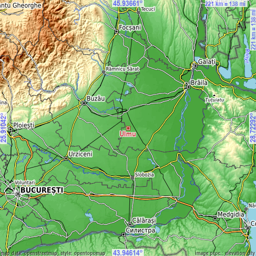
| \ | Map #1 | Map #2 | Topo.Map |
| Scale [m] | 26..55 m | 22..56 m | × |
| Scale [ft] | 85..180 ft | 72..184 ft | × |
| Average | 40.6 m = 133 ft | 40.1 m = 132 ft | × |
| Width | 6.92 km = 4.3 mi | 13.83 km = 8.6 mi | 221.3 km = 137.5 mi |
| Height | 6.92 km = 4.3 mi | 13.83 km = 8.6 mi | 221.3 km = 137.5 mi |
| ↑Max Latitude | 44.981093° | 45.012169° | 45.93661° |
| Latitude at center | 44.95° | 44.95° | 44.95° |
| ↓Min Latitude | 44.91889° | 44.887764° | 43.94614° |
| ← Min Longitude | 27.272725° | 27.228779° | 25.91042° |
| Longitude center | 27.31667° | 27.31667° | 27.31667° |
| →Max Longitude | 27.360615° | 27.404561° | 28.72292° |
Nearby cities:
Cities around Ulmu sort by population:
• Ruşeţu elevation 47 m
7.9 km,  270°
270°
• Dudeşti 44 m
10.7 km,  121°
121°
• Făurei 42 m
15.3 km,  345°
345°
• Cireşu 43 m
2.6 km,  90°
90°
• Zăvoaia 35 m
13.1 km, 90°
• Surdila-Găiseanca 37 m
13 km,  5°
5°
• Tătaru 41 m
14.9 km,  141°
141°
• Largu 48 m
13.2 km,  278°
278°
• Surdila-Greci 39 m
13.6 km,  343°
343°
• Lunca 44 m
10.2 km,  306°
306°
• Jugureanu 43 m
3.1 km,  255°
255°
• C.a. Rosetti 49 m
15.9 km, 312°
Multilingual:
 En español:
Ulmu elevación 43 m.
 En France:
Ulmu élévation 43 m.


Sources and notes:
- [note 1] Map square and city borders are not equal. Map elevation data is calculated only from area inside that square.
- [src 1] Elevation data from geonames database provided with same terms of usage.
- [src 2] The elevation map of Ulmu is generated using elevation data from NASA's 3 arcsec (90m) resolution SRTM data.
- [src 3] Base (background) map © OpenStreetMap contributors tiles are generated by Geofabrik and OpenTopoMap.
Copyright & License:
This Ulmu Elevation Map is licensed under CC BY-SA. You may reuse any part from this page, if you give a proper credit by linking to this URL:
 More info on terms of use page.