Ungheni elevation
Ungheni (Mureş, Oraş Ungheni), Romania elevation is 297 meters and Ungheni elevation in feet is 974 ft above sea level [src 1]. Ungheni is a seat of a second-order administrative division (feature code) with elevation that is 45 meters (148 ft) bigger than average city elevation in Romania.
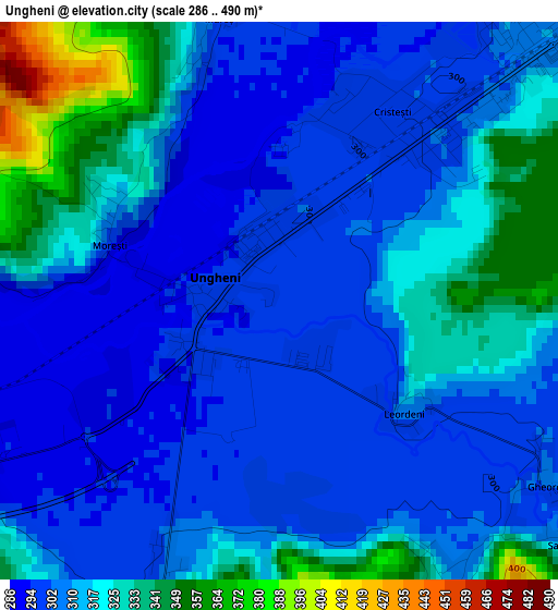
Below is the Elevation map of Ungheni, which displays elevation range with different colors. Scale of the first map is from 286 to 490 m (938 to 1608 ft) with average elevation of 312.9 meters (=1027 ft) [note 1]
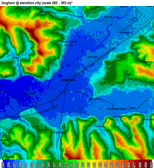
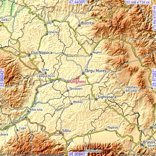
These maps also provides idea of topography and contour of this city, they are displayed at different zoom levels. More info about maps, scale and edge coordinates you can find below images.
| \ | Map #1 | Map #2 | Topo.Map |
| Scale [m] | 286..490 m | 280..503 m | × |
| Scale [ft] | 938..1608 ft | 919..1650 ft | × |
| Average | 312.9 m = 1027 ft | 341 m = 1119 ft | × |
| Width | 6.73 km = 4.2 mi | 13.46 km = 8.4 mi | 215.3 km = 133.8 mi |
| Height | 6.73 km = 4.2 mi | 13.46 km = 8.4 mi | 215.3 km = 133.8 mi |
| ↑Max Latitude | 46.513581° | 46.543815° | 47.44301° |
| Latitude at center | 46.48333° | 46.48333° | 46.48333° |
| ↓Min Latitude | 46.453062° | 46.422778° | 45.50641° |
| ← Min Longitude | 24.422725° | 24.378779° | 23.06042° |
| Longitude center | 24.46667° | 24.46667° | 24.46667° |
| →Max Longitude | 24.510615° | 24.554561° | 25.87292° |
Nearby cities:
Cities around Ungheni sort by population:
• Târgu-Mureş elevation 319 m
9.6 km,  46°
46°
• Sâncraiu de Mureş 308 m
8.8 km,  31°
31°
• Pănet 318 m
8 km,  1°
1°
• Cristeşti 298 m
2.2 km, 34°
• Crăciuneşti 311 m
8.9 km,  92°
92°
• Remetea 352 m
10.7 km,  19°
19°
• Sânpaul 284 m
9.7 km,  247°
247°
• Gheorghe Doja 299 m
3.2 km,  125°
125°
• Suplac 347 m
11.8 km,  160°
160°
• Nazna 305 m
6.4 km, 25°
• Valea Izvoarelor 310 m
8.5 km,  234°
234°
• Sântana de Mureş 311 m
11.2 km, 34°
Multilingual:
 En español:
Ungheni elevación 297 m.
 En France:
Ungheni élévation 297 m.


Sources and notes:
- [note 1] Map square and city borders are not equal. Map elevation data is calculated only from area inside that square.
- [src 1] Elevation data from geonames database provided with same terms of usage.
- [src 2] The elevation map of Ungheni is generated using elevation data from NASA's 3 arcsec (90m) resolution SRTM data.
- [src 3] Base (background) map © OpenStreetMap contributors tiles are generated by Geofabrik and OpenTopoMap.
Copyright & License:
This Ungheni Elevation Map is licensed under CC BY-SA. You may reuse any part from this page, if you give a proper credit by linking to this URL:
 More info on terms of use page.