Urmeniş elevation
Urmeniş (Bistriţa-Năsăud, Comuna Urmeniş), Romania elevation is 350 meters and Urmeniş elevation in feet is 1148 ft above sea level [src 1]. Urmeniş is a seat of a second-order administrative division (feature code) with elevation that is 98 meters (322 ft) bigger than average city elevation in Romania.
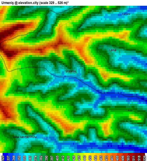
Below is the Elevation map of Urmeniş, which displays elevation range with different colors. Scale of the first map is from 329 to 526 m (1079 to 1726 ft) with average elevation of 405.4 meters (=1330 ft) [note 1]
These maps also provides idea of topography and contour of this city, they are displayed at different zoom levels. More info about maps, scale and edge coordinates you can find below images.
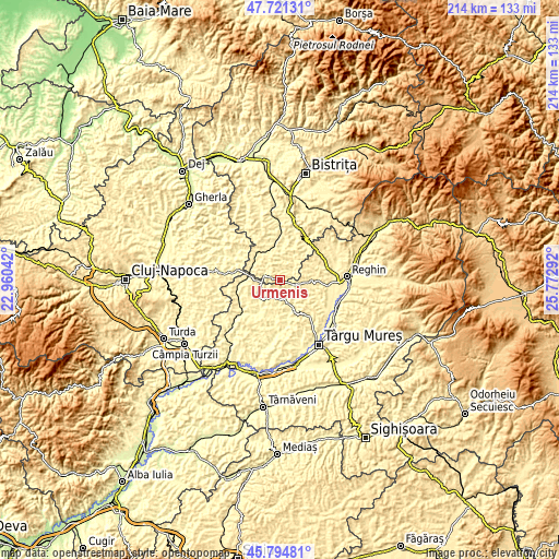
| \ | Map #1 | Topo.Map |
| Scale [m] | 329..526 m | × |
| Scale [ft] | 1079..1726 ft | × |
| Average | 405.4 m = 1330 ft | × |
| Width | 6.69 km = 4.2 mi | 214.2 km = 133.1 mi |
| Height | 6.69 km = 4.2 mi | 214.2 km = 133.1 mi |
| ↑Max Latitude | 46.796763° | 47.72131° |
| Latitude at center | 46.76667° | 46.76667° |
| ↓Min Latitude | 46.73656° | 45.79481° |
| ← Min Longitude | 24.322725° | 22.96042° |
| Longitude center | 24.36667° | 24.36667° |
| →Max Longitude | 24.410615° | 25.77292° |
Nearby cities:
Cities around Urmeniş sort by population:
• Râciu elevation 332 m
9.6 km,  164°
164°
• Pogăceaua 369 m
10.6 km,  208°
208°
• Fărăgău 395 m
11.4 km,  90°
90°
• Şincai 396 m
13 km,  174°
174°
• Milaş 379 m
7.5 km,  42°
42°
• Ocnița 369 m
14.1 km, 40°
• Miceştii de Câmpie 384 m
11.8 km,  341°
341°
• Sânpetru de Câmpie 343 m
9.7 km,  234°
234°
• Băla 420 m
11.6 km,  118°
118°
• Silivașu de Câmpie 376 m
5.4 km,  290°
290°
• Crăiești 335 m
4.6 km,  102°
102°
• Cozma 449 m
13.9 km,  66°
66°
Multilingual:
 En español:
Urmeniş elevación 350 m.
 En France:
Urmeniş élévation 350 m.


Sources and notes:
- [note 1] Map square and city borders are not equal. Map elevation data is calculated only from area inside that square.
- [src 1] Elevation data from geonames database provided with same terms of usage.
- [src 2] The elevation map of Urmeniş is generated using elevation data from NASA's 3 arcsec (90m) resolution SRTM data.
- [src 3] Base (background) map © OpenStreetMap contributors tiles are generated by Geofabrik and OpenTopoMap.
Copyright & License:
This Urmeniş Elevation Map is licensed under CC BY-SA. You may reuse any part from this page, if you give a proper credit by linking to this URL:
 More info on terms of use page.