Valea Largă elevation
Valea Largă (Mureş, Comuna Valea Largă), Romania elevation is 304 meters and Valea Largă elevation in feet is 997 ft above sea level [src 1]. Valea Largă is a seat of a second-order administrative division (feature code) with elevation that is 52 meters (171 ft) bigger than average city elevation in Romania.
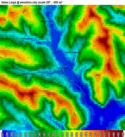
Below is the Elevation map of Valea Largă, which displays elevation range with different colors. Scale of the first map is from 287 to 459 m (942 to 1506 ft) with average elevation of 352.8 meters (=1157 ft) [note 1]
These maps also provides idea of topography and contour of this city, they are displayed at different zoom levels. More info about maps, scale and edge coordinates you can find below images.
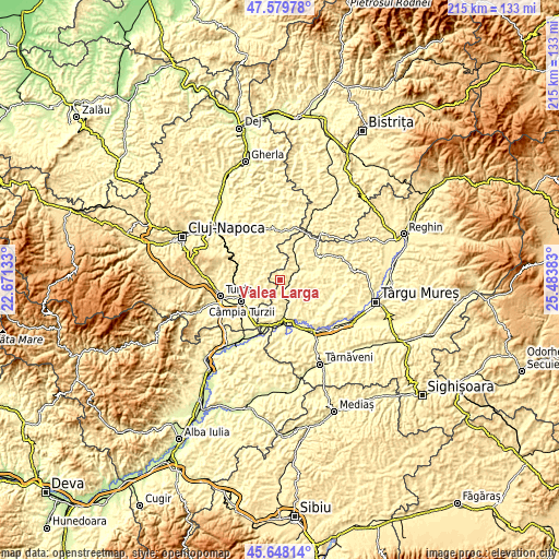
| \ | Map #1 | Topo.Map |
| Scale [m] | 287..459 m | × |
| Scale [ft] | 942..1506 ft | × |
| Average | 352.8 m = 1157 ft | × |
| Width | 6.71 km = 4.2 mi | 214.8 km = 133.5 mi |
| Height | 6.71 km = 4.2 mi | 214.8 km = 133.5 mi |
| ↑Max Latitude | 46.652743° | 47.57978° |
| Latitude at center | 46.62257° | 46.62257° |
| ↓Min Latitude | 46.59238° | 45.64814° |
| ← Min Longitude | 24.033635° | 22.67133° |
| Longitude center | 24.07758° | 24.07758° |
| →Max Longitude | 24.121525° | 25.48383° |
Nearby cities:
Cities around Valea Largă sort by population:
• Tritenii de Jos elevation 342 m
7.4 km,  233°
233°
• Frata 403 m
8.9 km,  346°
346°
• Ceanu Mare 421 m
10.9 km,  296°
296°
• Poduri 327 m
1.1 km, 231°
• Bârza 299 m
9.1 km,  152°
152°
• Zau de Câmpie 307 m
4.2 km,  103°
103°
• Şăulia 370 m
10.7 km,  83°
83°
• Pădureni 350 m
5.1 km, 229°
• Soporu de Câmpie 369 m
9.8 km,  326°
326°
• Tritenii de Sus 362 m
6.3 km,  252°
252°
• Sânger 301 m
8.5 km, 147°
• Miheşu de Câmpie 363 m
8.7 km,  39°
39°
Multilingual:
 En español:
Valea Largă elevación 304 m.
 En France:
Valea Largă élévation 304 m.
 Auf Deutsch:
Valea Largă höhe über dem Meeresspiegel ist 304 m.

Sources and notes:
- [note 1] Map square and city borders are not equal. Map elevation data is calculated only from area inside that square.
- [src 1] Elevation data from geonames database provided with same terms of usage.
- [src 2] The elevation map of Valea Largă is generated using elevation data from NASA's 3 arcsec (90m) resolution SRTM data.
- [src 3] Base (background) map © OpenStreetMap contributors tiles are generated by Geofabrik and OpenTopoMap.
Copyright & License:
This Valea Largă Elevation Map is licensed under CC BY-SA. You may reuse any part from this page, if you give a proper credit by linking to this URL:
 More info on terms of use page.