Vidra elevation
Vidra (Vrancea, Comuna Vidra), Romania elevation is 275 meters and Vidra elevation in feet is 902 ft above sea level [src 1]. Vidra is a seat of a second-order administrative division (feature code) with elevation that is 23 meters (75 ft) bigger than average city elevation in Romania.
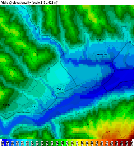
Below is the Elevation map of Vidra, which displays elevation range with different colors. Scale of the first map is from 213 to 622 m (699 to 2041 ft) with average elevation of 318.4 meters (=1045 ft) [note 1]
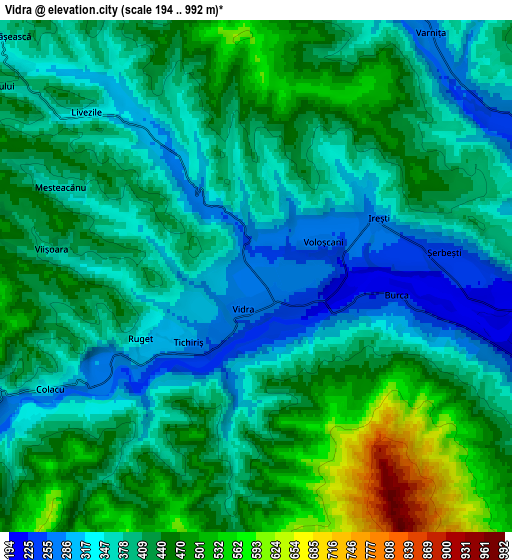
These maps also provides idea of topography and contour of this city, they are displayed at different zoom levels. More info about maps, scale and edge coordinates you can find below images.
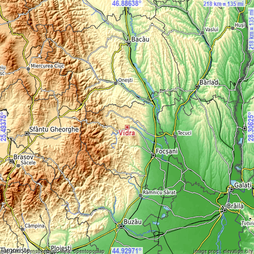
| \ | Map #1 | Map #2 | Topo.Map |
| Scale [m] | 213..622 m | 194..992 m | × |
| Scale [ft] | 699..2041 ft | 636..3255 ft | × |
| Average | 318.4 m = 1045 ft | 403.9 m = 1325 ft | × |
| Width | 6.8 km = 4.2 mi | 13.6 km = 8.5 mi | 217.6 km = 135.2 mi |
| Height | 6.8 km = 4.2 mi | 13.6 km = 8.5 mi | 217.5 km = 135.1 mi |
| ↑Max Latitude | 45.947235° | 45.977782° | 46.88638° |
| Latitude at center | 45.91667° | 45.91667° | 45.91667° |
| ↓Min Latitude | 45.886089° | 45.85549° | 44.92971° |
| ← Min Longitude | 26.856055° | 26.812109° | 25.49375° |
| Longitude center | 26.9° | 26.9° | 26.9° |
| →Max Longitude | 26.943945° | 26.987891° | 28.30625° |
Nearby cities:
Cities around Vidra sort by population:
• Vizantea-Mânăstirească elevation 365 m
11.7 km,  309°
309°
• Străoane 326 m
11.7 km,  80°
80°
• Răcoasa 372 m
9.4 km,  352°
352°
• Fitioneşti 305 m
13.8 km,  57°
57°
• Câmpuri 361 m
14 km,  321°
321°
• Mătăcina 378 m
8.6 km,  244°
244°
• Năruja 410 m
12.9 km,  224°
224°
• Găgești 155 m
13.8 km,  119°
119°
• Burca 216 m
3.8 km,  97°
97°
• Irești 284 m
3.7 km,  66°
66°
• Valea Sării 353 m
9 km, 240°
• Bârseşti 423 m
12.9 km,  270°
270°
Multilingual:
 En español:
Vidra elevación 275 m.
 En France:
Vidra élévation 275 m.


Sources and notes:
- [note 1] Map square and city borders are not equal. Map elevation data is calculated only from area inside that square.
- [src 1] Elevation data from geonames database provided with same terms of usage.
- [src 2] The elevation map of Vidra is generated using elevation data from NASA's 3 arcsec (90m) resolution SRTM data.
- [src 3] Base (background) map © OpenStreetMap contributors tiles are generated by Geofabrik and OpenTopoMap.
Copyright & License:
This Vidra Elevation Map is licensed under CC BY-SA. You may reuse any part from this page, if you give a proper credit by linking to this URL:
 More info on terms of use page.