Voievodeasa elevation
Voievodeasa (Suceava, Comuna Suceviţa), Romania elevation is 512 meters and Voievodeasa elevation in feet is 1680 ft above sea level [src 1]. Voievodeasa is a populated place (feature code) with elevation that is 260 meters (853 ft) bigger than average city elevation in Romania.
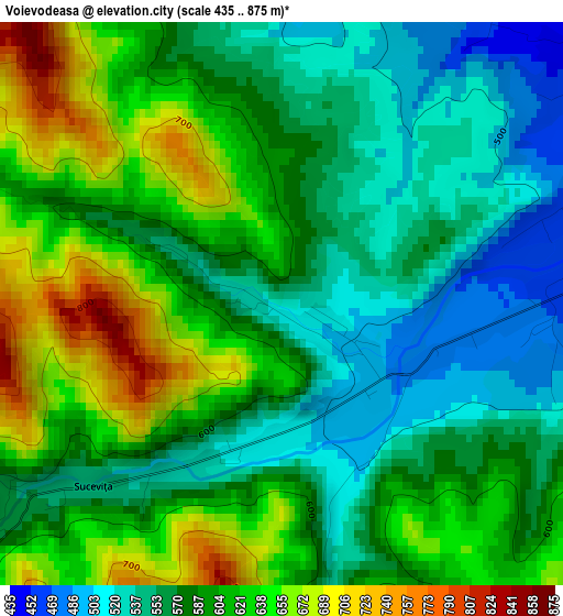
Below is the Elevation map of Voievodeasa, which displays elevation range with different colors. Scale of the first map is from 435 to 875 m (1427 to 2871 ft) with average elevation of 591.3 meters (=1940 ft) [note 1]
These maps also provides idea of topography and contour of this city, they are displayed at different zoom levels. More info about maps, scale and edge coordinates you can find below images.
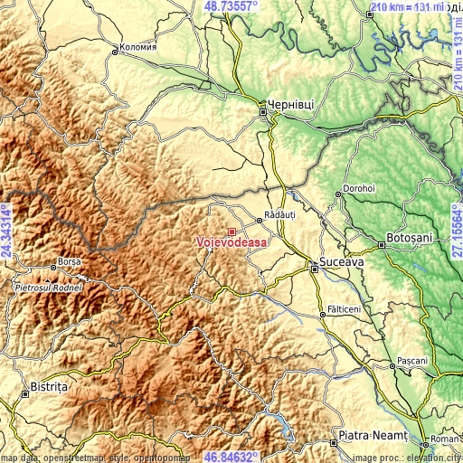
| \ | Map #1 | Topo.Map |
| Scale [m] | 435..875 m | × |
| Scale [ft] | 1427..2871 ft | × |
| Average | 591.3 m = 1940 ft | × |
| Width | 6.56 km = 4.1 mi | 210.1 km = 130.5 mi |
| Height | 6.56 km = 4.1 mi | 210.1 km = 130.5 mi |
| ↑Max Latitude | 47.829041° | 48.73557° |
| Latitude at center | 47.79953° | 47.79953° |
| ↓Min Latitude | 47.770002° | 46.84632° |
| ← Min Longitude | 25.705445° | 24.34314° |
| Longitude center | 25.74939° | 25.74939° |
| →Max Longitude | 25.793335° | 27.15564° |
Nearby cities:
Cities around Voievodeasa sort by population:
• Marginea elevation 437 m
5.4 km,  69°
69°
• Volovăţ 383 m
11.4 km,  80°
80°
• Vicovu de Jos 438 m
11.2 km,  353°
353°
• Horodnic de Sus 423 m
7.1 km,  50°
50°
• Solca 472 m
13.4 km,  145°
145°
• Putna 603 m
12.4 km,  307°
307°
• Bilca 422 m
13 km,  0°
0°
• Voitinel 454 m
9.4 km, 3°
• Suceviţa 584 m
3 km,  233°
233°
• Horodnic de Jos 425 m
8.9 km,  35°
35°
• Burla 428 m
13.3 km,  94°
94°
• Clit 444 m
9.5 km,  122°
122°
Multilingual:
 En español:
Voievodeasa elevación 512 m.
 En France:
Voievodeasa élévation 512 m.
 Auf Deutsch:
Voievodeasa höhe über dem Meeresspiegel ist 512 m.

Sources and notes:
- [note 1] Map square and city borders are not equal. Map elevation data is calculated only from area inside that square.
- [src 1] Elevation data from geonames database provided with same terms of usage.
- [src 2] The elevation map of Voievodeasa is generated using elevation data from NASA's 3 arcsec (90m) resolution SRTM data.
- [src 3] Base (background) map © OpenStreetMap contributors tiles are generated by Geofabrik and OpenTopoMap.
Copyright & License:
This Voievodeasa Elevation Map is licensed under CC BY-SA. You may reuse any part from this page, if you give a proper credit by linking to this URL:
 More info on terms of use page.