Sector 3 elevation
Sector 3 (Bucureşti, Municipiul Bucureşti), Romania elevation is 76 meters and Sector 3 elevation in feet is 249 ft above sea level [src 1]. Sector 3 is a section of populated place (feature code) with elevation that is 176 meters (577 ft) smaller than average city elevation in Romania.
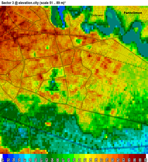
Below is the Elevation map of Sector 3, which displays elevation range with different colors. Scale of the first map is from 51 to 89 m (167 to 292 ft) with average elevation of 70.9 meters (=233 ft) [note 1]
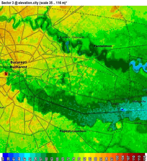
These maps also provides idea of topography and contour of this city, they are displayed at different zoom levels. More info about maps, scale and edge coordinates you can find below images.
| \ | Map #1 | Map #2 | Topo.Map |
| Scale [m] | 51..89 m | 35..116 m | × |
| Scale [ft] | 167..292 ft | 115..381 ft | × |
| Average | 70.9 m = 233 ft | 73.6 m = 241 ft | × |
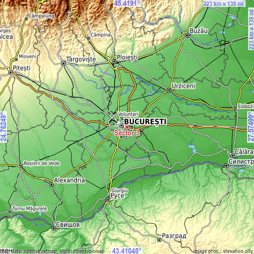
| Width | 6.98 km = 4.3 mi | 13.96 km = 8.7 mi | 223.3 km = 138.8 mi |
| Height | 6.98 km = 4.3 mi | 13.96 km = 8.7 mi | 223.3 km = 138.8 mi |
| ↑Max Latitude | 44.454777° | 44.486137° | 45.4191° |
| Latitude at center | 44.4234° | 44.4234° | 44.4234° |
| ↓Min Latitude | 44.392006° | 44.360596° | 43.41045° |
| ← Min Longitude | 26.124795° | 26.080849° | 24.76249° |
| Longitude center | 26.16874° | 26.16874° | 26.16874° |
| →Max Longitude | 26.212685° | 26.256631° | 27.57499° |
Nearby cities:
Cities around Sector 3 sort by population:
• Bucharest elevation 83 m
5.1 km,  281°
281°
• Sector 2 80 m
4.3 km,  319°
319°
• Sector 4 79 m
6.5 km,  215°
215°
• Voluntari 82 m
7.4 km,  2°
2°
• Pantelimon 72 m
3.9 km,  40°
40°
• Popeşti-Leordeni 76 m
4.5 km,  182°
182°
• Glina 67 m
7.8 km,  124°
124°
• Dobroeşti 72 m
3.2 km,  21°
21°
• Fundeni 76 m
4 km,  356°
356°
• Cățelu 64 m
4.6 km, 119°
• Căldăraru 65 m
7.6 km,  98°
98°
• Bucuresti 82 m
5.7 km, 275°
Multilingual:
 En español:
Sector 3 elevación 76 m.
 En France:
Sector 3 élévation 76 m.


Sources and notes:
- [note 1] Map square and city borders are not equal. Map elevation data is calculated only from area inside that square.
- [src 1] Elevation data from geonames database provided with same terms of usage.
- [src 2] The elevation map of Sector 3 is generated using elevation data from NASA's 3 arcsec (90m) resolution SRTM data.
- [src 3] Base (background) map © OpenStreetMap contributors tiles are generated by Geofabrik and OpenTopoMap.
Copyright & License:
This Sector 3 Elevation Map is licensed under CC BY-SA. You may reuse any part from this page, if you give a proper credit by linking to this URL:
 More info on terms of use page.