I. C. Brătianu elevation
I. C. Brătianu (Tulcea, Comuna I.C.Brãtianu), Romania elevation is 5 meters and I. C. Brătianu elevation in feet is 16 ft above sea level [src 1]. I. C. Brătianu is a seat of a second-order administrative division (feature code) with elevation that is 247 meters (810 ft) smaller than average city elevation in Romania.
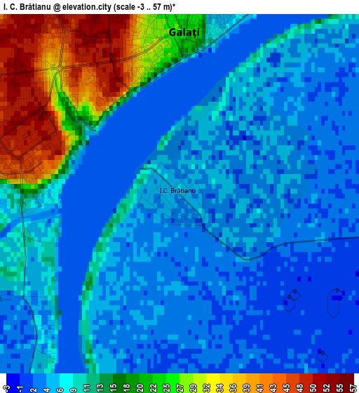
Below is the Elevation map of I. C. Brătianu, which displays elevation range with different colors. Scale of the first map is from -3 to 57 m (-10 to 187 ft) with average elevation of 9.9 meters (=32 ft) [note 1]
These maps also provides idea of topography and contour of this city, they are displayed at different zoom levels. More info about maps, scale and edge coordinates you can find below images.
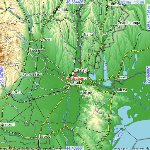
| \ | Map #1 | Topo.Map |
| Scale [m] | -3..57 m | × |
| Scale [ft] | -10..187 ft | × |
| Average | 9.9 m = 32 ft | × |
| Width | 6.86 km = 4.3 mi | 219.6 km = 136.5 mi |
| Height | 6.86 km = 4.3 mi | 219.5 km = 136.4 mi |
| ↑Max Latitude | 45.436655° | 46.38449° |
| Latitude at center | 45.40581° | 45.40581° |
| ↓Min Latitude | 45.374948° | 44.40988° |
| ← Min Longitude | 28.009865° | 26.64756° |
| Longitude center | 28.05381° | 28.05381° |
| →Max Longitude | 28.097755° | 29.46006° |
Nearby cities:
Cities around I. C. Brătianu sort by population:
• Galaţi elevation 3 m
3.5 km,  355°
355°
• Jijila 28 m
14 km,  147°
147°
• Vădeni 4 m
10.4 km,  245°
245°
• Vânători 86 m
14.5 km,  348°
348°
• Smârdan 56 m
12.8 km,  312°
312°
• Şendreni 6 m
10.7 km,  266°
266°
• Văcăreni 27 m
14.3 km,  129°
129°
• Grindu 2 m
12.7 km,  92°
92°
• Garvăn 42 m
10.7 km, 127°
• Baldovinești 4 m
14.5 km,  230°
230°
• Smârdan 5 m
13.8 km,  196°
196°
• Cișmele 59 m
15.6 km,  321°
321°
Multilingual:
 En español:
I. C. Brătianu elevación 5 m.
 En France:
I. C. Brătianu élévation 5 m.
 Auf Deutsch:
I. C. Brătianu höhe über dem Meeresspiegel ist 5 m.

Sources and notes:
- [note 1] Map square and city borders are not equal. Map elevation data is calculated only from area inside that square.
- [src 1] Elevation data from geonames database provided with same terms of usage.
- [src 2] The elevation map of I. C. Brătianu is generated using elevation data from NASA's 3 arcsec (90m) resolution SRTM data.
- [src 3] Base (background) map © OpenStreetMap contributors tiles are generated by Geofabrik and OpenTopoMap.
Copyright & License:
This I. C. Brătianu Elevation Map is licensed under CC BY-SA. You may reuse any part from this page, if you give a proper credit by linking to this URL:
 More info on terms of use page.