Ar Rayyān elevation
Ar Rayyān (Baladīyat ar Rayyān), Qatar elevation is 23 meters and Ar Rayyān elevation in feet is 75 ft above sea level [src 1]. Ar Rayyān is a seat of a first-order administrative division (feature code) with elevation that is 4 meters (13 ft) bigger than average city elevation in Qatar.
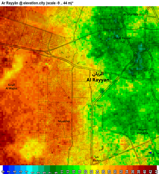
Below is the Elevation map of Ar Rayyān, which displays elevation range with different colors. Scale of the first map is from -9 to 44 m (-30 to 144 ft) with average elevation of 23.4 meters (=77 ft) [note 1]
These maps also provides idea of topography and contour of this city, they are displayed at different zoom levels. More info about maps, scale and edge coordinates you can find below images.
| \ | Map #1 | Map #2 | Topo.Map |
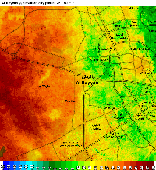
| Scale [m] | -9..44 m | -26..50 m | × |
| Scale [ft] | -30..144 ft | -85..164 ft | × |
| Average | 23.4 m = 77 ft | 25 m = 82 ft | × |
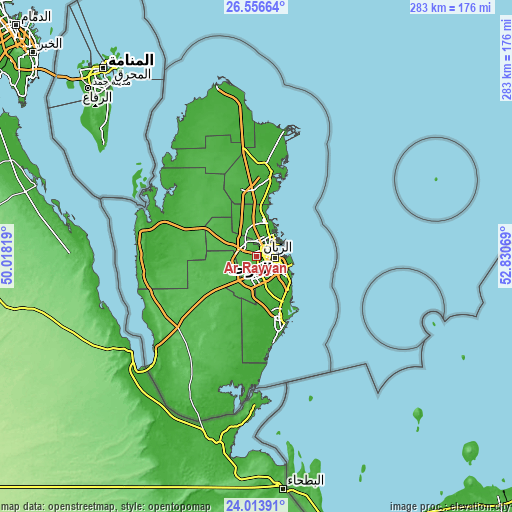
| Width | 8.84 km = 5.5 mi | 17.67 km = 11 mi | 282.7 km = 175.7 mi |
| Height | 8.84 km = 5.5 mi | 17.67 km = 11 mi | 282.7 km = 175.7 mi |
| ↑Max Latitude | 25.331666° | 25.37138° | 26.55664° |
| Latitude at center | 25.29194° | 25.29194° | 25.29194° |
| ↓Min Latitude | 25.252201° | 25.212448° | 24.01391° |
| ← Min Longitude | 51.380495° | 51.336549° | 50.01819° |
| Longitude center | 51.42444° | 51.42444° | 51.42444° |
| →Max Longitude | 51.468385° | 51.512331° | 52.83069° |
Nearby cities:
Cities around Ar Rayyān sort by population:
• Doha elevation 11 m
10.7 km,  93°
93°
• Umm Şalāl Muḩammad 25 m
13.8 km,  352°
352°
• Al Wakrah 9 m
22.4 km,  126°
126°
• Al Khawr 10 m
44.3 km,  10°
10°
• Ash Shīḩānīyah 43 m
22.1 km,  293°
293°
• Musay‘īd 7 m
35.7 km,  159°
159°
• Al Wukayr 7 m
19.3 km,  144°
144°
• Umm Bāb 56 m
62.7 km,  262°
262°
• Al Ghuwayrīyah 24 m
62.3 km,  343°
343°
• Al Jumaylīyah 28 m
48.7 km,  316°
316°
• Az̧ Z̧a‘āyin 6 m
32.3 km, 10°
• Umm Şalāl ‘Alī 16 m
20 km, 352°
Multilingual:
 En español:
Ar Rayyān elevación 23 m.
 En France:
Al Rayyan élévation 23 m.
 Auf Deutsch:
ar-Rayyan höhe über dem Meeresspiegel ist 23 m.

Sources and notes:
- [note 1] Map square and city borders are not equal. Map elevation data is calculated only from area inside that square.
- [src 1] Elevation data from geonames database provided with same terms of usage.
- [src 2] The elevation map of Ar Rayyān is generated using elevation data from NASA's 3 arcsec (90m) resolution SRTM data.
- [src 3] Base (background) map © OpenStreetMap contributors tiles are generated by Geofabrik and OpenTopoMap.
Copyright & License:
This Ar Rayyān Elevation Map is licensed under CC BY-SA. You may reuse any part from this page, if you give a proper credit by linking to this URL:
 More info on terms of use page.