Capitán Pablo Lagerenza elevation
Capitán Pablo Lagerenza (Alto Paraguay, Bahia Negra), Paraguay elevation is 204 meters and Capitán Pablo Lagerenza elevation in feet is 669 ft above sea level [src 1]. Capitán Pablo Lagerenza is a populated place (feature code) with elevation that is 30 meters (98 ft) bigger than average city elevation in Paraguay.
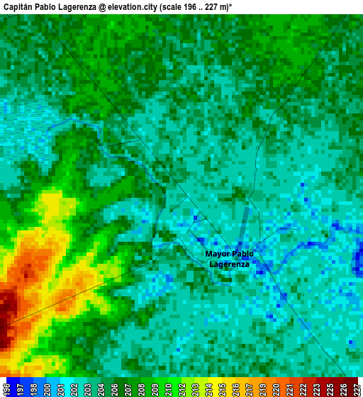
Below is the Elevation map of Capitán Pablo Lagerenza, which displays elevation range with different colors. Scale of the first map is from 196 to 227 m (643 to 745 ft) with average elevation of 205.4 meters (=674 ft) [note 1]
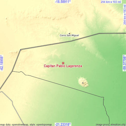
These maps also provides idea of topography and contour of this city, they are displayed at different zoom levels. More info about maps, scale and edge coordinates you can find below images.
| \ | Map #1 | Topo.Map |
| Scale [m] | 196..227 m | × |
| Scale [ft] | 643..745 ft | × |
| Average | 205.4 m = 674 ft | × |
| Width | 9.19 km = 5.7 mi | 294 km = 182.7 mi |
| Height | 9.19 km = 5.7 mi | 294 km = 182.7 mi |
| ↑Max Latitude | -19.875348° | -18.58911° |
| Latitude at center | -19.91667° | -19.91667° |
| ↓Min Latitude | -19.957982° | -21.23318° |
| ← Min Longitude | -60.827275° | -62.18958° |
| Longitude center | -60.78333° | -60.78333° |
| →Max Longitude | -60.739385° | -59.37708° |
Nearby cities:
Cities around Capitán Pablo Lagerenza sort by population:
• Filadelfia elevation 140 m
280.4 km,  163°
163°
• Colonia Menno 128 m
290.3 km, 159°
• Colonia Neuland 138 m
313.5 km,  167°
167°
• Fuerte Olimpo 84 m
327.9 km,  112°
112°
Multilingual:
 En español:
Capitán Pablo Lagerenza elevación 204 m.
 En France:
Capitán Pablo Lagerenza élévation 204 m.
 Auf Deutsch:
Capitán Pablo Lagerenza höhe über dem Meeresspiegel ist 204 m.
 На русском:
Capitán Pablo Lagerenza высота над уровнем моря 204 м
Sources and notes:
- [note 1] Map square and city borders are not equal. Map elevation data is calculated only from area inside that square.
- [src 1] Elevation data from geonames database provided with same terms of usage.
- [src 2] The elevation map of Capitán Pablo Lagerenza is generated using elevation data from NASA's 3 arcsec (90m) resolution SRTM data.
- [src 3] Base (background) map © OpenStreetMap contributors tiles are generated by Geofabrik and OpenTopoMap.
Copyright & License:
This Capitán Pablo Lagerenza Elevation Map is licensed under CC BY-SA. You may reuse any part from this page, if you give a proper credit by linking to this URL:
 More info on terms of use page.