Atyrá elevation
Atyrá (Cordillera, Atyra), Paraguay elevation is 140 meters and Atyrá elevation in feet is 459 ft above sea level [src 1]. Atyrá is a populated place (feature code) with elevation that is 34 meters (112 ft) smaller than average city elevation in Paraguay.
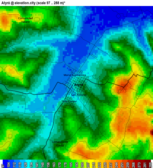
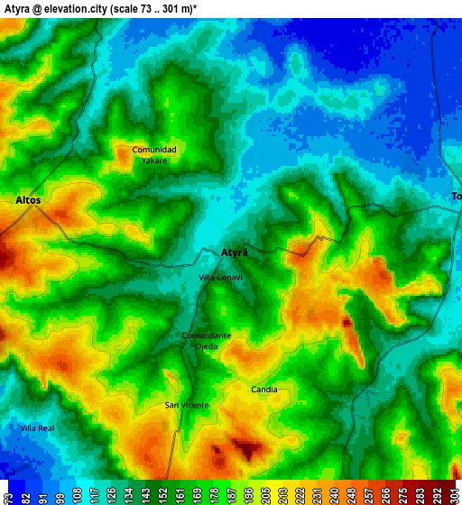
Below is the Elevation map of Atyrá, which displays elevation range with different colors. Scale of the first map is from 97 to 288 m (318 to 945 ft) with average elevation of 159.6 meters (=524 ft) [note 1]
These maps also provides idea of topography and contour of this city, they are displayed at different zoom levels. More info about maps, scale and edge coordinates you can find below images.
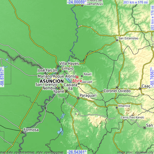
| \ | Map #1 | Map #2 | Topo.Map |
| Scale [m] | 97..288 m | 73..301 m | × |
| Scale [ft] | 318..945 ft | 240..988 ft | × |
| Average | 159.6 m = 524 ft | 156.7 m = 514 ft | × |
| Width | 8.84 km = 5.5 mi | 17.67 km = 11 mi | 282.8 km = 175.7 mi |
| Height | 8.84 km = 5.5 mi | 17.67 km = 11 mi | 282.8 km = 175.7 mi |
| ↑Max Latitude | -25.239016° | -25.19926° | -24.00059° |
| Latitude at center | -25.27876° | -25.27876° | -25.27876° |
| ↓Min Latitude | -25.318491° | -25.358208° | -26.54361° |
| ← Min Longitude | -57.215865° | -57.259811° | -58.57817° |
| Longitude center | -57.17192° | -57.17192° | -57.17192° |
| →Max Longitude | -57.127975° | -57.084029° | -55.76567° |
Nearby cities:
Cities around Atyrá sort by population:
• Itauguá elevation 140 m
22.3 km,  235°
235°
• Caacupé 180 m
12.3 km,  165°
165°
• Areguá 114 m
21.7 km,  260°
260°
• Piribebuy 253 m
24.5 km,  147°
147°
• Tobatí 125 m
9.1 km,  77°
77°
• Ypacarai 91 m
18.5 km,  219°
219°
• Eusebio Ayala 155 m
24.2 km,  118°
118°
• Emboscada 93 m
22.9 km,  308°
308°
• Altos 202 m
8.5 km,  282°
282°
• San Bernardino 74 m
13 km,  254°
254°
• Pirayú 110 m
23.7 km,  195°
195°
• Arroyos y Esteros 90 m
26 km,  16°
16°
Multilingual:
 En español:
Atyrá elevación 140 m.
 En France:
Atyrá élévation 140 m.


Sources and notes:
- [note 1] Map square and city borders are not equal. Map elevation data is calculated only from area inside that square.
- [src 1] Elevation data from geonames database provided with same terms of usage.
- [src 2] The elevation map of Atyrá is generated using elevation data from NASA's 3 arcsec (90m) resolution SRTM data.
- [src 3] Base (background) map © OpenStreetMap contributors tiles are generated by Geofabrik and OpenTopoMap.
Copyright & License:
This Atyrá Elevation Map is licensed under CC BY-SA. You may reuse any part from this page, if you give a proper credit by linking to this URL:
 More info on terms of use page.