Colonia General Alfredo Stroessner elevation
Colonia General Alfredo Stroessner (Caaguazú, J Eulogio Estigarribia), Paraguay elevation is 308 meters and Colonia General Alfredo Stroessner elevation in feet is 1010 ft above sea level [src 1]. Colonia General Alfredo Stroessner is a populated locality (feature code) with elevation that is 134 meters (440 ft) bigger than average city elevation in Paraguay.
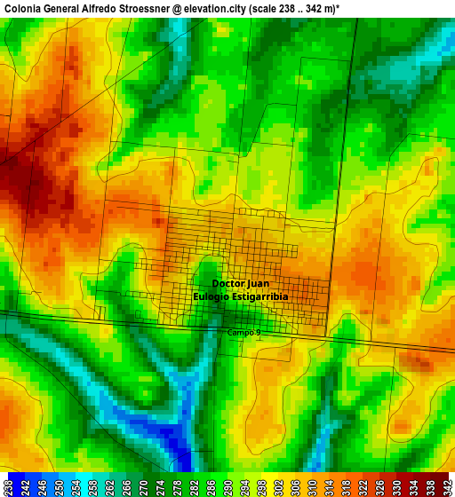
Below is the Elevation map of Colonia General Alfredo Stroessner, which displays elevation range with different colors. Scale of the first map is from 238 to 342 m (781 to 1122 ft) with average elevation of 292.7 meters (=960 ft) [note 1]
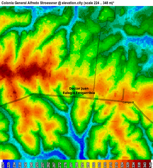
These maps also provides idea of topography and contour of this city, they are displayed at different zoom levels. More info about maps, scale and edge coordinates you can find below images.
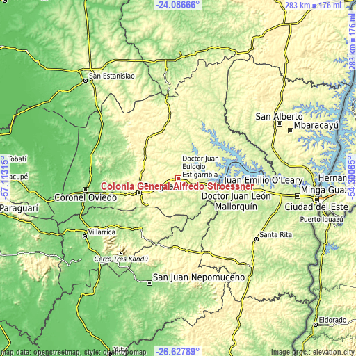
| \ | Map #1 | Map #2 | Topo.Map |
| Scale [m] | 238..342 m | 224..348 m | × |
| Scale [ft] | 781..1122 ft | 735..1142 ft | × |
| Average | 292.7 m = 960 ft | 283.7 m = 931 ft | × |
| Width | 8.83 km = 5.5 mi | 17.66 km = 11 mi | 282.6 km = 175.6 mi |
| Height | 8.83 km = 5.5 mi | 17.66 km = 11 mi | 282.6 km = 175.6 mi |
| ↑Max Latitude | -25.324234° | -25.284506° | -24.08666° |
| Latitude at center | -25.36395° | -25.36395° | -25.36395° |
| ↓Min Latitude | -25.403653° | -25.443342° | -26.62789° |
| ← Min Longitude | -55.750845° | -55.794791° | -57.11315° |
| Longitude center | -55.7069° | -55.7069° | -55.7069° |
| →Max Longitude | -55.662955° | -55.619009° | -54.30065° |
Nearby cities:
Cities around Colonia General Alfredo Stroessner sort by population:
• Caaguazú elevation 336 m
33.3 km,  249°
249°
• Doctor Juan León Mallorquín 247 m
46.1 km,  99°
99°
• Repatriación 269 m
30.8 km,  232°
232°
• Doctor Juan Manuel Frutos 312 m
12.8 km,  260°
260°
• Itakyry 246 m
70.1 km,  53°
53°
• Colonia Mauricio José Troche 146 m
62.1 km, 248°
• Yhú 320 m
40.4 km,  327°
327°
• Cecilio Baez 204 m
63 km,  301°
301°
• Natalicio Talavera 135 m
66.6 km,  243°
243°
• San Joaquín 346 m
50.3 km,  317°
317°
• Independencia 172 m
67 km, 237°
• General Higinio Morínigo 370 m
68.5 km,  197°
197°
Multilingual:
 En español:
Colonia General Alfredo Stroessner elevación 308 m.
 En France:
Colonia General Alfredo Stroessner élévation 308 m.
 Auf Deutsch:
Colonia General Alfredo Stroessner höhe über dem Meeresspiegel ist 308 m.
 На русском:
Colonia General Alfredo Stroessner высота над уровнем моря 308 м
Sources and notes:
- [note 1] Map square and city borders are not equal. Map elevation data is calculated only from area inside that square.
- [src 1] Elevation data from geonames database provided with same terms of usage.
- [src 2] The elevation map of Colonia General Alfredo Stroessner is generated using elevation data from NASA's 3 arcsec (90m) resolution SRTM data.
- [src 3] Base (background) map © OpenStreetMap contributors tiles are generated by Geofabrik and OpenTopoMap.
Copyright & License:
This Colonia General Alfredo Stroessner Elevation Map is licensed under CC BY-SA. You may reuse any part from this page, if you give a proper credit by linking to this URL:
 More info on terms of use page.