Pilar elevation
Pilar (Ñeembucú), Paraguay elevation is 55 meters and Pilar elevation in feet is 180 ft above sea level [src 1]. Pilar is a seat of a first-order administrative division (feature code) with elevation that is 119 meters (390 ft) smaller than average city elevation in Paraguay.
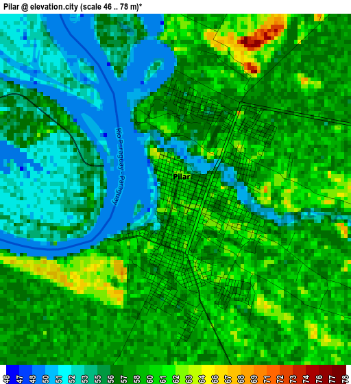
Below is the Elevation map of Pilar, which displays elevation range with different colors. Scale of the first map is from 46 to 78 m (151 to 256 ft) with average elevation of 57.1 meters (=187 ft) [note 1]
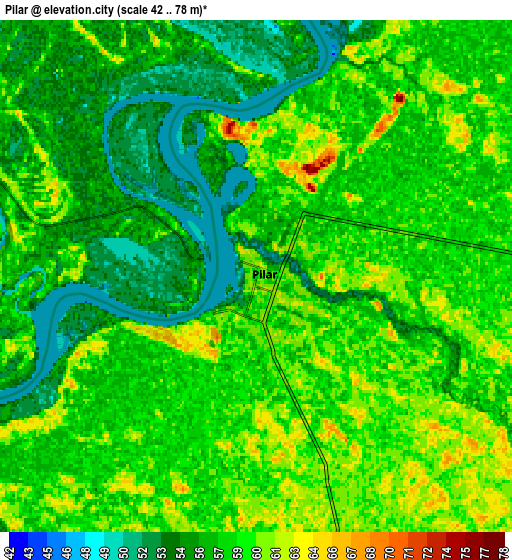
These maps also provides idea of topography and contour of this city, they are displayed at different zoom levels. More info about maps, scale and edge coordinates you can find below images.
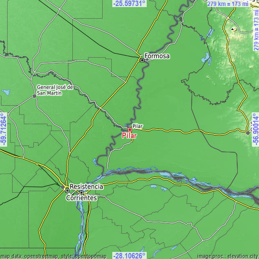
| \ | Map #1 | Map #2 | Topo.Map |
| Scale [m] | 46..78 m | 42..78 m | × |
| Scale [ft] | 151..256 ft | 138..256 ft | × |
| Average | 57.1 m = 187 ft | 57.5 m = 189 ft | × |
| Width | 8.72 km = 5.4 mi | 17.44 km = 10.8 mi | 279 km = 173.4 mi |
| Height | 8.72 km = 5.4 mi | 17.44 km = 10.8 mi | 279 km = 173.4 mi |
| ↑Max Latitude | -26.819529° | -26.780304° | -25.59731° |
| Latitude at center | -26.85874° | -26.85874° | -26.85874° |
| ↓Min Latitude | -26.897938° | -26.937122° | -28.10626° |
| ← Min Longitude | -58.350335° | -58.394281° | -59.71264° |
| Longitude center | -58.30639° | -58.30639° | -58.30639° |
| →Max Longitude | -58.262445° | -58.218499° | -56.90014° |
Nearby cities:
Cities around Pilar sort by population:
• San Juan Bautista elevation 128 m
117.1 km,  79°
79°
• Santa Rosa Misiones 200 m
144.6 km,  91°
91°
• Quiindy 195 m
145.1 km,  47°
47°
• Acahay 155 m
155.7 km, 47°
• Villa Florida 70 m
126.5 km,  65°
65°
• Caapucú 138 m
131.6 km,  58°
58°
• Santiago 128 m
155.6 km,  101°
101°
• Santa María 122 m
136.5 km, 86°
• San Patricio 166 m
148.2 km, 94°
• General José Eduvigis Díaz 61 m
38.6 km,  189°
189°
• San Miguel 96 m
131 km, 72°
• Cerrito 66 m
85 km,  129°
129°
Multilingual:
 En español:
Pilar elevación 55 m.
 En France:
Pilar élévation 55 m.


Sources and notes:
- [note 1] Map square and city borders are not equal. Map elevation data is calculated only from area inside that square.
- [src 1] Elevation data from geonames database provided with same terms of usage.
- [src 2] The elevation map of Pilar is generated using elevation data from NASA's 3 arcsec (90m) resolution SRTM data.
- [src 3] Base (background) map © OpenStreetMap contributors tiles are generated by Geofabrik and OpenTopoMap.
Copyright & License:
This Pilar Elevation Map is licensed under CC BY-SA. You may reuse any part from this page, if you give a proper credit by linking to this URL:
 More info on terms of use page.