San Isidro de Curuguaty elevation
San Isidro de Curuguaty (Canindeyú, Curuguaty), Paraguay elevation is 215 meters and San Isidro de Curuguaty elevation in feet is 705 ft above sea level [src 1]. San Isidro de Curuguaty is a populated place (feature code) with elevation that is 41 meters (135 ft) bigger than average city elevation in Paraguay.
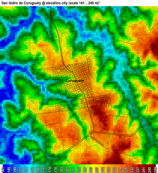
Below is the Elevation map of San Isidro de Curuguaty, which displays elevation range with different colors. Scale of the first map is from 141 to 249 m (463 to 817 ft) with average elevation of 190.7 meters (=626 ft) [note 1]
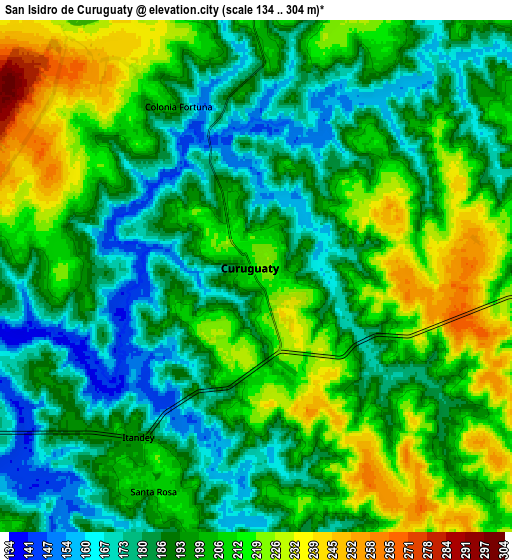
These maps also provides idea of topography and contour of this city, they are displayed at different zoom levels. More info about maps, scale and edge coordinates you can find below images.
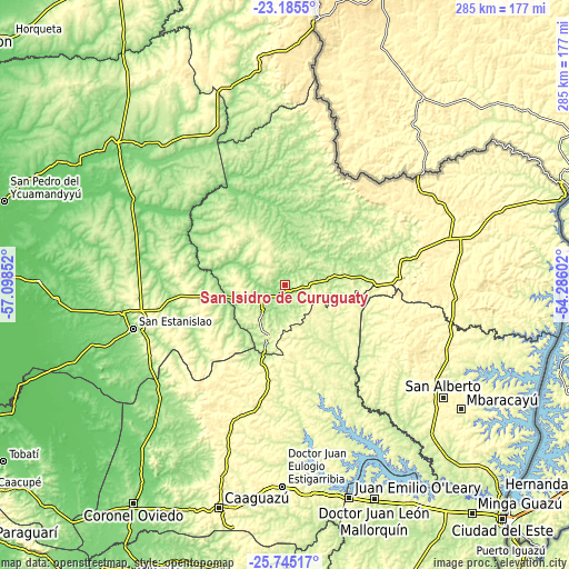
| \ | Map #1 | Map #2 | Topo.Map |
| Scale [m] | 141..249 m | 134..304 m | × |
| Scale [ft] | 463..817 ft | 440..997 ft | × |
| Average | 190.7 m = 626 ft | 197.9 m = 649 ft | × |
| Width | 8.89 km = 5.5 mi | 17.79 km = 11.1 mi | 284.6 km = 176.8 mi |
| Height | 8.89 km = 5.5 mi | 17.79 km = 11.1 mi | 284.6 km = 176.8 mi |
| ↑Max Latitude | -24.431836° | -24.39182° | -23.1855° |
| Latitude at center | -24.47184° | -24.47184° | -24.47184° |
| ↓Min Latitude | -24.511831° | -24.55181° | -25.74517° |
| ← Min Longitude | -55.736215° | -55.780161° | -57.09852° |
| Longitude center | -55.69227° | -55.69227° | -55.69227° |
| →Max Longitude | -55.648325° | -55.604379° | -54.28602° |
Nearby cities:
Cities around San Isidro de Curuguaty sort by population:
• Nueva Esperanza elevation 370 m
84.8 km,  92°
92°
• Capiíbary 314 m
50.2 km,  223°
223°
• Itakyry 246 m
79.2 km,  136°
136°
• Ygatimi 197 m
39 km,  7°
7°
• Guayaybi 284 m
75.3 km,  264°
264°
• Yhú 320 m
69.2 km,  199°
199°
• Cecilio Baez 204 m
86.9 km, 219°
• Colonia Minga Porá 306 m
91.3 km,  118°
118°
• San Joaquín 346 m
71.3 km,  209°
209°
• Mbutuý 174 m
83.8 km,  228°
228°
• Yataity del Norte 183 m
77.7 km,  238°
238°
• Corpus Christi 432 m
87.9 km,  60°
60°
Multilingual:
 En español:
San Isidro de Curuguaty elevación 215 m.
 En France:
San Isidro de Curuguaty élévation 215 m.
 Auf Deutsch:
San Isidro de Curuguaty höhe über dem Meeresspiegel ist 215 m.
 На русском:
San Isidro de Curuguaty высота над уровнем моря 215 м
Sources and notes:
- [note 1] Map square and city borders are not equal. Map elevation data is calculated only from area inside that square.
- [src 1] Elevation data from geonames database provided with same terms of usage.
- [src 2] The elevation map of San Isidro de Curuguaty is generated using elevation data from NASA's 3 arcsec (90m) resolution SRTM data.
- [src 3] Base (background) map © OpenStreetMap contributors tiles are generated by Geofabrik and OpenTopoMap.
Copyright & License:
This San Isidro de Curuguaty Elevation Map is licensed under CC BY-SA. You may reuse any part from this page, if you give a proper credit by linking to this URL:
 More info on terms of use page.