Koror Town elevation
Koror Town (Koror), Palau elevation is 29 meters and Koror Town elevation in feet is 95 ft above sea level [src 1]. Koror Town is a populated place (feature code) with elevation that is 4 meters (13 ft) bigger than average city elevation in Palau.
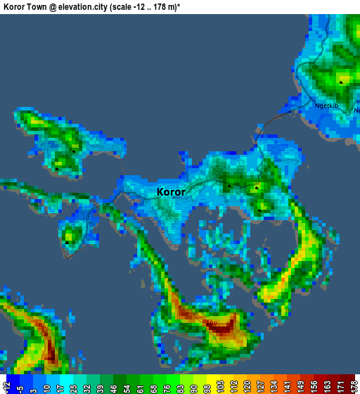
Below is the Elevation map of Koror Town, which displays elevation range with different colors. Scale of the first map is from -12 to 178 m (-39 to 584 ft) with average elevation of 40.7 meters (=134 ft) [note 1]
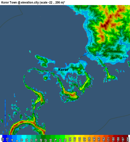
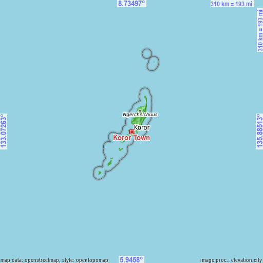
These maps also provides idea of topography and contour of this city, they are displayed at different zoom levels. More info about maps, scale and edge coordinates you can find below images.
| \ | Map #1 | Map #2 | Topo.Map |
| Scale [m] | -12..178 m | -22..206 m | × |
| Scale [ft] | -39..584 ft | -72..676 ft | × |
| Average | 40.7 m = 134 ft | 58.3 m = 191 ft | × |
| Width | 9.69 km = 6 mi | 19.38 km = 12 mi | 310.1 km = 192.7 mi |
| Height | 9.69 km = 6 mi | 19.38 km = 12 mi | 310.2 km = 192.7 mi |
| ↑Max Latitude | 7.386153° | 7.429731° | 8.73497° |
| Latitude at center | 7.34257° | 7.34257° | 7.34257° |
| ↓Min Latitude | 7.298983° | 7.255392° | 5.9458° |
| ← Min Longitude | 134.434935° | 134.390989° | 133.07263° |
| Longitude center | 134.47888° | 134.47888° | 134.47888° |
| →Max Longitude | 134.522825° | 134.566771° | 135.88513° |
Nearby cities:
Cities around Koror Town sort by population:
• Koror elevation 34 m
0.7 km,  243°
243°
• Kloulklubed 9 m
41.5 km,  216°
216°
• Ulimang 11 m
36.1 km,  29°
29°
• Ngchesar Hamlet 18 m
20.2 km,  45°
45°
• Melekeok Village 16 m
24.3 km, 45°
• Ngchemiangel 20 m
11.5 km,  358°
358°
• Ngerkeai 17 m
29.3 km,  36°
36°
• Ngardmau 24 m
31.5 km,  19°
19°
• Imeong Hamlet 26 m
21.7 km,  14°
14°
• Ngetkib 23 m
4.7 km,  58°
58°
• Ngerulmud 72 m
23.8 km, 42°
• Ngereklmadel 40 m
16.2 km,  2°
2°
Multilingual:
 En español:
Koror Town elevación 29 m.
 En France:
Koror Town élévation 29 m.
 Auf Deutsch:
Koror Town höhe über dem Meeresspiegel ist 29 m.

Sources and notes:
- [note 1] Map square and city borders are not equal. Map elevation data is calculated only from area inside that square.
- [src 1] Elevation data from geonames database provided with same terms of usage.
- [src 2] The elevation map of Koror Town is generated using elevation data from NASA's 3 arcsec (90m) resolution SRTM data.
- [src 3] Base (background) map © OpenStreetMap contributors tiles are generated by Geofabrik and OpenTopoMap.
Copyright & License:
This Koror Town Elevation Map is licensed under CC BY-SA. You may reuse any part from this page, if you give a proper credit by linking to this URL:
 More info on terms of use page.