Barcelos elevation
Barcelos (Braga), Portugal elevation is 24 meters and Barcelos elevation in feet is 79 ft above sea level [src 1]. Barcelos is a seat of a second-order administrative division (feature code) with elevation that is 144 meters (472 ft) smaller than average city elevation in Portugal.
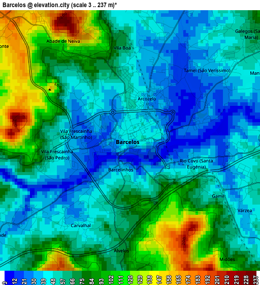
Below is the Elevation map of Barcelos, which displays elevation range with different colors. Scale of the first map is from 3 to 237 m (10 to 778 ft) with average elevation of 66 meters (=217 ft) [note 1]
These maps also provides idea of topography and contour of this city, they are displayed at different zoom levels. More info about maps, scale and edge coordinates you can find below images.
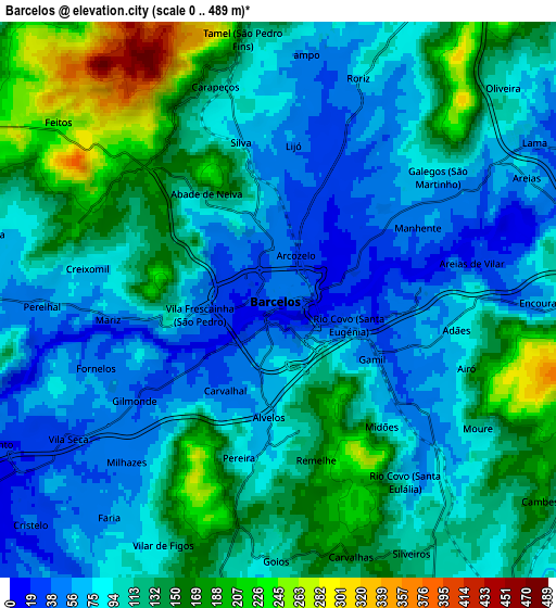
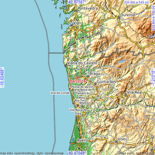
| \ | Map #1 | Map #2 | Topo.Map |
| Scale [m] | 3..237 m | 0..489 m | × |
| Scale [ft] | 10..778 ft | 0..1604 ft | × |
| Average | 66 m = 217 ft | 109.9 m = 361 ft | × |
| Width | 7.32 km = 4.5 mi | 14.63 km = 9.1 mi | 234.1 km = 145.5 mi |
| Height | 7.32 km = 4.5 mi | 14.63 km = 9.1 mi | 234.1 km = 145.5 mi |
| ↑Max Latitude | 41.564629° | 41.5975° | 42.57587° |
| Latitude at center | 41.53174° | 41.53174° | 41.53174° |
| ↓Min Latitude | 41.498835° | 41.465913° | 40.47049° |
| ← Min Longitude | -8.662375° | -8.706321° | -10.02468° |
| Longitude center | -8.61843° | -8.61843° | -8.61843° |
| →Max Longitude | -8.574485° | -8.530539° | -7.21218° |
Nearby cities:
Cities around Barcelos sort by population:
• Galegos elevation 85 m
5.2 km,  48°
48°
• Vila Frescainha 56 m
1.9 km,  292°
292°
• Gueral 72 m
8.2 km,  186°
186°
• Vila Cova 67 m
8.4 km,  284°
284°
• Chavão 174 m
8.9 km,  171°
171°
• Faria 53 m
7 km,  219°
219°
• Vilar de Figos 111 m
6.9 km,  205°
205°
• Várzea 40 m
3.4 km,  122°
122°
• Cristelo 42 m
8.8 km,  228°
228°
• Perelhal 61 m
5.9 km,  268°
268°
• Mariz 63 m
4.4 km,  264°
264°
• Vila Seca 35 m
6.6 km,  237°
237°
Multilingual:
 En español:
Barcelos elevación 24 m.
 En France:
Barcelos élévation 24 m.


Sources and notes:
- [note 1] Map square and city borders are not equal. Map elevation data is calculated only from area inside that square.
- [src 1] Elevation data from geonames database provided with same terms of usage.
- [src 2] The elevation map of Barcelos is generated using elevation data from NASA's 3 arcsec (90m) resolution SRTM data.
- [src 3] Base (background) map © OpenStreetMap contributors tiles are generated by Geofabrik and OpenTopoMap.
Copyright & License:
This Barcelos Elevation Map is licensed under CC BY-SA. You may reuse any part from this page, if you give a proper credit by linking to this URL:
 More info on terms of use page.