Beduido elevation
Beduido (Aveiro, Estarreja), Portugal elevation is 33 meters and Beduido elevation in feet is 108 ft above sea level [src 1]. Beduido is a populated place (feature code) with elevation that is 135 meters (443 ft) smaller than average city elevation in Portugal.
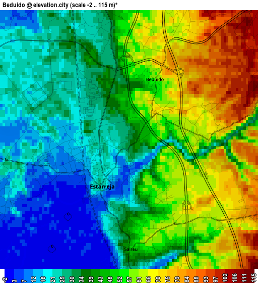
Below is the Elevation map of Beduido, which displays elevation range with different colors. Scale of the first map is from -2 to 115 m (-7 to 377 ft) with average elevation of 42 meters (=138 ft) [note 1]
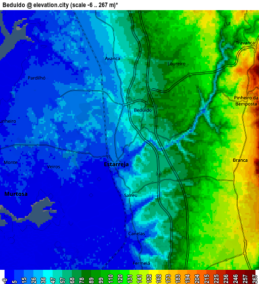
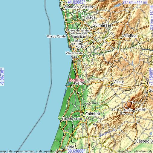
These maps also provides idea of topography and contour of this city, they are displayed at different zoom levels. More info about maps, scale and edge coordinates you can find below images.
| \ | Map #1 | Map #2 | Topo.Map |
| Scale [m] | -2..115 m | -6..267 m | × |
| Scale [ft] | -7..377 ft | -20..876 ft | × |
| Average | 42 m = 138 ft | 58.6 m = 192 ft | × |
| Width | 7.4 km = 4.6 mi | 14.8 km = 9.2 mi | 236.9 km = 147.2 mi |
| Height | 7.4 km = 4.6 mi | 14.8 km = 9.2 mi | 236.8 km = 147.1 mi |
| ↑Max Latitude | 40.797546° | 40.830805° | 41.82082° |
| Latitude at center | 40.76427° | 40.76427° | 40.76427° |
| ↓Min Latitude | 40.730977° | 40.697668° | 39.69066° |
| ← Min Longitude | -8.605045° | -8.648991° | -9.96735° |
| Longitude center | -8.5611° | -8.5611° | -8.5611° |
| →Max Longitude | -8.517155° | -8.473209° | -7.15485° |
Nearby cities:
Cities around Beduido sort by population:
• Ovar elevation 16 m
11.8 km,  332°
332°
• Oliveira de Azemeis 221 m
11.2 km,  40°
40°
• Cucujães 236 m
13 km,  20°
20°
• Murtosa 8 m
7.1 km,  244°
244°
• Albergaria-a-Velha 128 m
10.5 km,  139°
139°
• Válega 41 m
8.2 km,  348°
348°
• São João 24 m
12.2 km,  341°
341°
• Avanca 34 m
4.9 km, 349°
• Branca 161 m
6.6 km,  87°
87°
• Pardilhó 9 m
6.7 km,  305°
305°
• Salreu 56 m
2.8 km,  173°
173°
• Estarreja 23 m
1.3 km,  226°
226°
Multilingual:
 En español:
Beduido elevación 33 m.
 En France:
Beduido élévation 33 m.


Sources and notes:
- [note 1] Map square and city borders are not equal. Map elevation data is calculated only from area inside that square.
- [src 1] Elevation data from geonames database provided with same terms of usage.
- [src 2] The elevation map of Beduido is generated using elevation data from NASA's 3 arcsec (90m) resolution SRTM data.
- [src 3] Base (background) map © OpenStreetMap contributors tiles are generated by Geofabrik and OpenTopoMap.
Copyright & License:
This Beduido Elevation Map is licensed under CC BY-SA. You may reuse any part from this page, if you give a proper credit by linking to this URL:
 More info on terms of use page.