Ermesinde elevation
Ermesinde (Porto, Valongo), Portugal elevation is 131 meters and Ermesinde elevation in feet is 430 ft above sea level [src 1]. Ermesinde is a populated place (feature code) with elevation that is 37 meters (121 ft) smaller than average city elevation in Portugal.
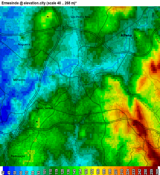
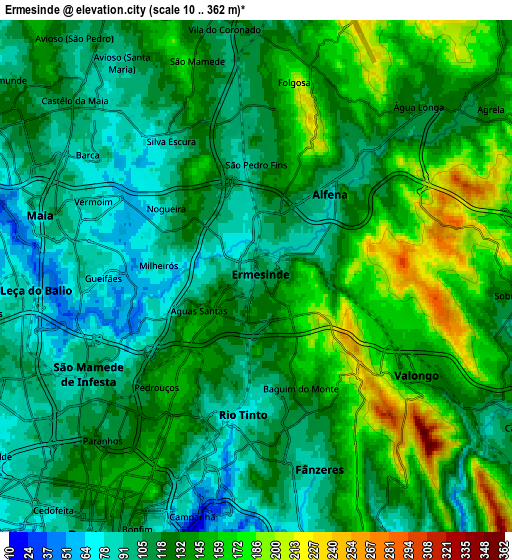
Below is the Elevation map of Ermesinde, which displays elevation range with different colors. Scale of the first map is from 40 to 268 m (131 to 879 ft) with average elevation of 120.9 meters (=397 ft) [note 1]
These maps also provides idea of topography and contour of this city, they are displayed at different zoom levels. More info about maps, scale and edge coordinates you can find below images.
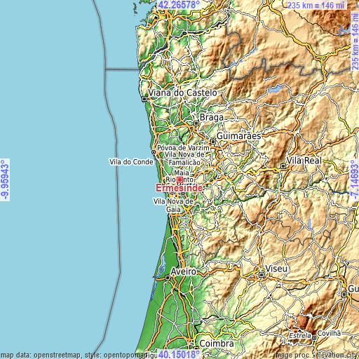
| \ | Map #1 | Map #2 | Topo.Map |
| Scale [m] | 40..268 m | 10..362 m | × |
| Scale [ft] | 131..879 ft | 33..1188 ft | × |
| Average | 120.9 m = 397 ft | 127.6 m = 419 ft | × |
| Width | 7.35 km = 4.6 mi | 14.7 km = 9.1 mi | 235.2 km = 146.1 mi |
| Height | 7.35 km = 4.6 mi | 14.7 km = 9.1 mi | 235.2 km = 146.1 mi |
| ↑Max Latitude | 41.249578° | 41.28261° | 42.26578° |
| Latitude at center | 41.21653° | 41.21653° | 41.21653° |
| ↓Min Latitude | 41.183465° | 41.150383° | 40.15018° |
| ← Min Longitude | -8.597125° | -8.641071° | -9.95943° |
| Longitude center | -8.55318° | -8.55318° | -8.55318° |
| →Max Longitude | -8.509235° | -8.465289° | -7.14693° |
Nearby cities:
Cities around Ermesinde sort by population:
• Rio Tinto elevation 88 m
4.2 km,  187°
187°
• Maia 93 m
6 km,  290°
290°
• Águas Santas 103 m
2 km,  249°
249°
• São Mamede de Infesta 95 m
5.6 km,  240°
240°
• Fânzeres 166 m
5.8 km,  160°
160°
• Valongo 126 m
5.5 km,  123°
123°
• Baguim do Monte 168 m
2.9 km, 159°
• Alfena 117 m
3.3 km,  46°
46°
• Pedrouços 156 m
4.1 km,  221°
221°
• Nogueira 77 m
4 km,  315°
315°
• Milheirós 68 m
2.9 km,  266°
266°
• Água Longa 116 m
6.3 km, 53°
Multilingual:
 En español:
Ermesinde elevación 131 m.
 En France:
Ermesinde élévation 131 m.
 Auf Deutsch:
Ermesinde höhe über dem Meeresspiegel ist 131 m.

Sources and notes:
- [note 1] Map square and city borders are not equal. Map elevation data is calculated only from area inside that square.
- [src 1] Elevation data from geonames database provided with same terms of usage.
- [src 2] The elevation map of Ermesinde is generated using elevation data from NASA's 3 arcsec (90m) resolution SRTM data.
- [src 3] Base (background) map © OpenStreetMap contributors tiles are generated by Geofabrik and OpenTopoMap.
Copyright & License:
This Ermesinde Elevation Map is licensed under CC BY-SA. You may reuse any part from this page, if you give a proper credit by linking to this URL:
 More info on terms of use page.