Esposende elevation
Esposende (Braga), Portugal elevation is 7 meters and Esposende elevation in feet is 23 ft above sea level [src 1]. Esposende is a seat of a second-order administrative division (feature code) with elevation that is 161 meters (528 ft) smaller than average city elevation in Portugal.
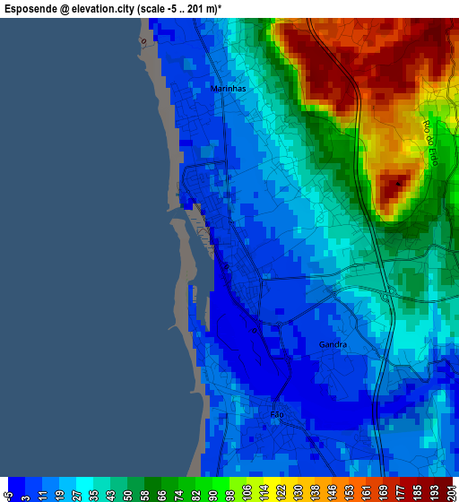
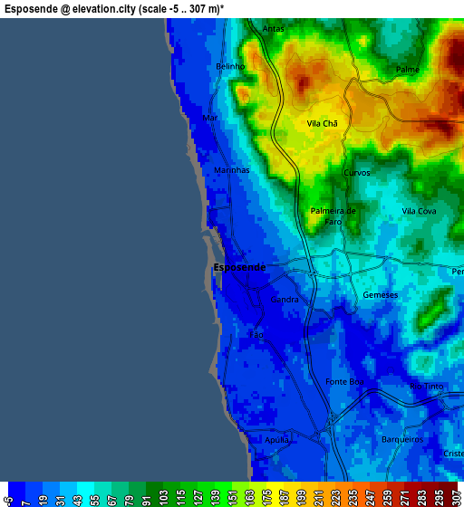
Below is the Elevation map of Esposende, which displays elevation range with different colors. Scale of the first map is from -5 to 201 m (-16 to 659 ft) with average elevation of 47.4 meters (=156 ft) [note 1]
These maps also provides idea of topography and contour of this city, they are displayed at different zoom levels. More info about maps, scale and edge coordinates you can find below images.
| \ | Map #1 | Map #2 | Topo.Map |
| Scale [m] | -5..201 m | -5..307 m | × |
| Scale [ft] | -16..659 ft | -16..1007 ft | × |
| Average | 47.4 m = 156 ft | 72.3 m = 237 ft | × |
| Width | 7.32 km = 4.5 mi | 14.63 km = 9.1 mi | 234.1 km = 145.5 mi |
| Height | 7.32 km = 4.5 mi | 14.63 km = 9.1 mi | 234.1 km = 145.5 mi |
| ↑Max Latitude | 41.568986° | 41.601856° | 42.58015° |
| Latitude at center | 41.5361° | 41.5361° | 41.5361° |
| ↓Min Latitude | 41.503197° | 41.470277° | 40.47492° |
| ← Min Longitude | -8.825955° | -8.869901° | -10.18826° |
| Longitude center | -8.78201° | -8.78201° | -8.78201° |
| →Max Longitude | -8.738065° | -8.694119° | -7.37576° |
Nearby cities:
Cities around Esposende sort by population:
• Apúlia e Fão elevation 5 m
2.8 km,  164°
164°
• Marinhas 15 m
2.6 km,  358°
358°
• Apúlia 10 m
5.9 km,  165°
165°
• Vila Cova 67 m
5.7 km,  73°
73°
• Estela 27 m
10 km, 165°
• Faria 53 m
10.9 km,  122°
122°
• Barqueiros 10 m
6.5 km,  140°
140°
• Cristelo 42 m
9.4 km,  131°
131°
• Perelhal 61 m
7.7 km,  94°
94°
• Gandra 15 m
2.3 km, 133°
• Mariz 63 m
9.3 km,  95°
95°
• Vila Seca 35 m
9 km, 116°
Multilingual:
 En español:
Esposende elevación 7 m.
 En France:
Esposende élévation 7 m.


Sources and notes:
- [note 1] Map square and city borders are not equal. Map elevation data is calculated only from area inside that square.
- [src 1] Elevation data from geonames database provided with same terms of usage.
- [src 2] The elevation map of Esposende is generated using elevation data from NASA's 3 arcsec (90m) resolution SRTM data.
- [src 3] Base (background) map © OpenStreetMap contributors tiles are generated by Geofabrik and OpenTopoMap.
Copyright & License:
This Esposende Elevation Map is licensed under CC BY-SA. You may reuse any part from this page, if you give a proper credit by linking to this URL:
 More info on terms of use page.