Mesão Frio elevation
Mesão Frio (Vila Real), Portugal elevation is 309 meters and Mesão Frio elevation in feet is 1014 ft above sea level [src 1]. Mesão Frio is a seat of a second-order administrative division (feature code) with elevation that is 141 meters (463 ft) bigger than average city elevation in Portugal.
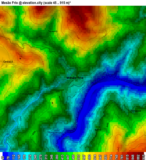
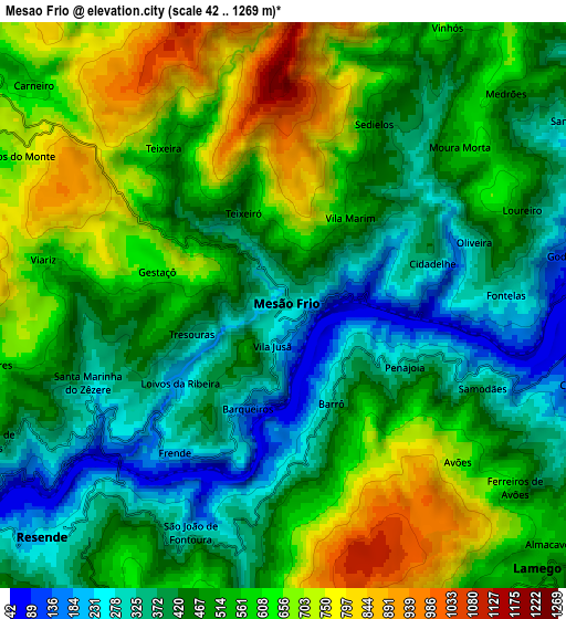
Below is the Elevation map of Mesão Frio, which displays elevation range with different colors. Scale of the first map is from 45 to 915 m (148 to 3002 ft) with average elevation of 390 meters (=1280 ft) [note 1]
These maps also provides idea of topography and contour of this city, they are displayed at different zoom levels. More info about maps, scale and edge coordinates you can find below images.
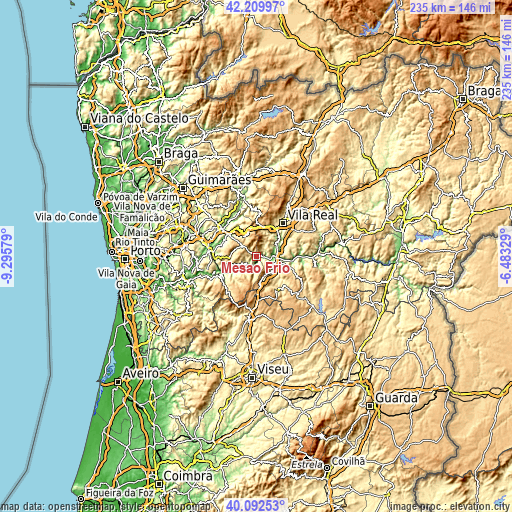
| \ | Map #1 | Map #2 | Topo.Map |
| Scale [m] | 45..915 m | 42..1269 m | × |
| Scale [ft] | 148..3002 ft | 138..4163 ft | × |
| Average | 390 m = 1280 ft | 510.7 m = 1676 ft | × |
| Width | 7.36 km = 4.6 mi | 14.72 km = 9.1 mi | 235.4 km = 146.3 mi |
| Height | 7.36 km = 4.6 mi | 14.71 km = 9.1 mi | 235.4 km = 146.3 mi |
| ↑Max Latitude | 41.192877° | 41.225937° | 42.20997° |
| Latitude at center | 41.1598° | 41.1598° | 41.1598° |
| ↓Min Latitude | 41.126706° | 41.093596° | 40.09253° |
| ← Min Longitude | -7.933485° | -7.977431° | -9.29579° |
| Longitude center | -7.88954° | -7.88954° | -7.88954° |
| →Max Longitude | -7.845595° | -7.801649° | -6.48329° |
Nearby cities:
Cities around Mesão Frio sort by population:
• Baião elevation 577 m
12.2 km,  271°
271°
• Vila Real 462 m
19.8 km,  37°
37°
• Lamego 502 m
9.6 km,  136°
136°
• Valadares 574 m
7.8 km,  259°
259°
• Amarante 96 m
20.4 km,  307°
307°
• Peso da Régua 146 m
8.6 km,  86°
86°
• Godim 117 m
7.3 km,  80°
80°
• Tarouca 527 m
18.5 km,  148°
148°
• Resende 232 m
8.8 km,  227°
227°
• Cinfães 404 m
19.4 km,  239°
239°
• Armamar 576 m
17.6 km,  109°
109°
• Santa Marta de Penaguião 278 m
10.5 km,  57°
57°
Multilingual:
 En español:
Mesão Frio elevación 309 m.
 En France:
Mesão Frio élévation 309 m.
 Auf Deutsch:
Mesão Frio höhe über dem Meeresspiegel ist 309 m.

Sources and notes:
- [note 1] Map square and city borders are not equal. Map elevation data is calculated only from area inside that square.
- [src 1] Elevation data from geonames database provided with same terms of usage.
- [src 2] The elevation map of Mesão Frio is generated using elevation data from NASA's 3 arcsec (90m) resolution SRTM data.
- [src 3] Base (background) map © OpenStreetMap contributors tiles are generated by Geofabrik and OpenTopoMap.
Copyright & License:
This Mesão Frio Elevation Map is licensed under CC BY-SA. You may reuse any part from this page, if you give a proper credit by linking to this URL:
 More info on terms of use page.