Pedroso elevation
Pedroso (Porto, Póvoa de Varzim), Portugal elevation is 35 meters and Pedroso elevation in feet is 115 ft above sea level [src 1]. Pedroso is a populated place (feature code) with elevation that is 133 meters (436 ft) smaller than average city elevation in Portugal.
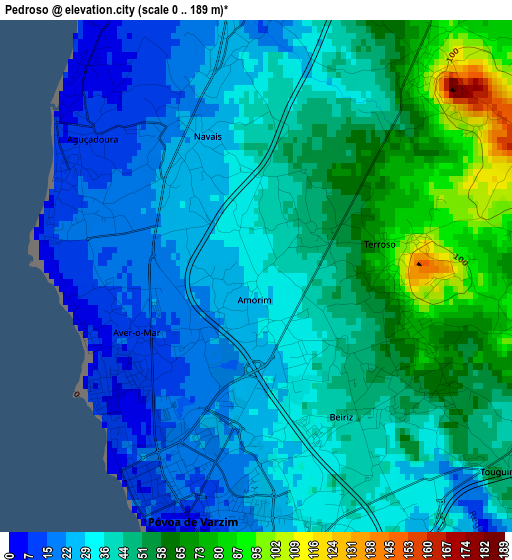
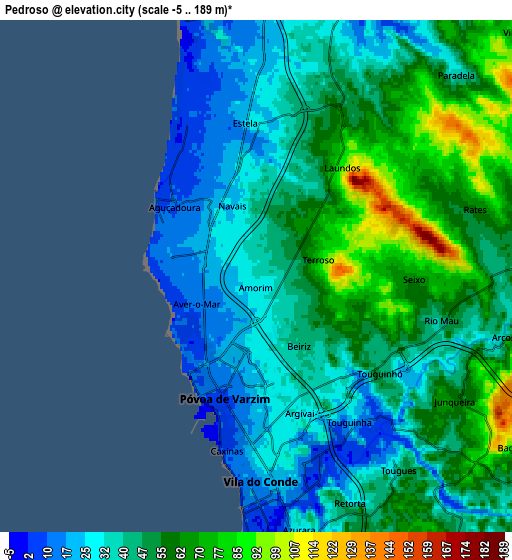
Below is the Elevation map of Pedroso, which displays elevation range with different colors. Scale of the first map is from 0 to 189 m (0 to 620 ft) with average elevation of 41.1 meters (=135 ft) [note 1]
These maps also provides idea of topography and contour of this city, they are displayed at different zoom levels. More info about maps, scale and edge coordinates you can find below images.
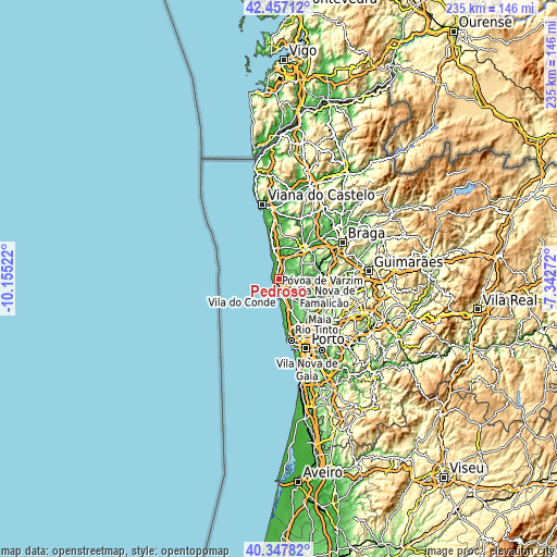
| \ | Map #1 | Map #2 | Topo.Map |
| Scale [m] | 0..189 m | -5..189 m | × |
| Scale [ft] | 0..620 ft | -16..620 ft | × |
| Average | 41.1 m = 135 ft | 46.8 m = 154 ft | × |
| Width | 7.33 km = 4.6 mi | 14.66 km = 9.1 mi | 234.5 km = 145.7 mi |
| Height | 7.33 km = 4.6 mi | 14.66 km = 9.1 mi | 234.5 km = 145.7 mi |
| ↑Max Latitude | 41.44398° | 41.476913° | 42.45712° |
| Latitude at center | 41.41103° | 41.41103° | 41.41103° |
| ↓Min Latitude | 41.378063° | 41.34508° | 40.34782° |
| ← Min Longitude | -8.792915° | -8.836861° | -10.15522° |
| Longitude center | -8.74897° | -8.74897° | -8.74897° |
| →Max Longitude | -8.705025° | -8.661079° | -7.34272° |
Nearby cities:
Cities around Pedroso sort by population:
• Póvoa de Varzim elevation 16 m
3.3 km,  201°
201°
• Vila do Conde 19 m
6.4 km,  177°
177°
• Aver-o-Mar 15 m
2.6 km,  257°
257°
• Árvore 36 m
8.4 km,  162°
162°
• Aguçadoura 9 m
3.3 km,  312°
312°
• Apúlia 10 m
8.3 km,  351°
351°
• Beiriz de Baixo 52 m
2.6 km,  126°
126°
• Amorim 34 m
0.7 km,  190°
190°
• Rio Mau 59 m
5.8 km,  97°
97°
• Estela 27 m
4.3 km,  356°
356°
• Argivai 32 m
4.1 km, 156°
• Cristelo 42 m
8.7 km,  29°
29°
Multilingual:
 En español:
Pedroso elevación 35 m.
 En France:
Pedroso élévation 35 m.


Sources and notes:
- [note 1] Map square and city borders are not equal. Map elevation data is calculated only from area inside that square.
- [src 1] Elevation data from geonames database provided with same terms of usage.
- [src 2] The elevation map of Pedroso is generated using elevation data from NASA's 3 arcsec (90m) resolution SRTM data.
- [src 3] Base (background) map © OpenStreetMap contributors tiles are generated by Geofabrik and OpenTopoMap.
Copyright & License:
This Pedroso Elevation Map is licensed under CC BY-SA. You may reuse any part from this page, if you give a proper credit by linking to this URL:
 More info on terms of use page.