Senhora da Hora elevation
Senhora da Hora (Porto, Matosinhos), Portugal elevation is 85 meters and Senhora da Hora elevation in feet is 279 ft above sea level [src 1]. Senhora da Hora is a populated place (feature code) with elevation that is 83 meters (272 ft) smaller than average city elevation in Portugal.
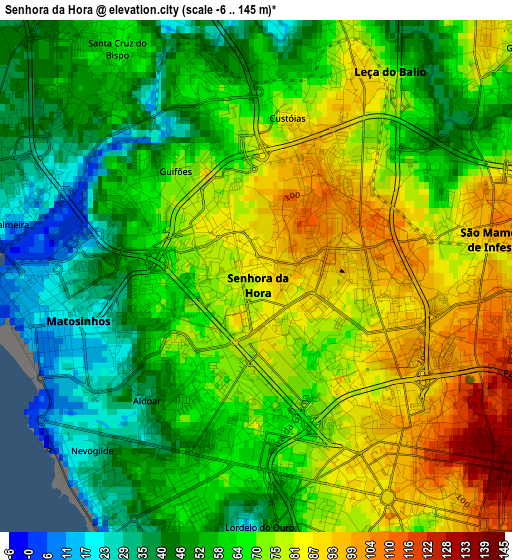
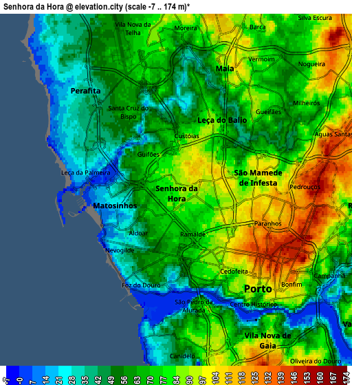
Below is the Elevation map of Senhora da Hora, which displays elevation range with different colors. Scale of the first map is from -6 to 145 m (-20 to 476 ft) with average elevation of 65.9 meters (=216 ft) [note 1]
These maps also provides idea of topography and contour of this city, they are displayed at different zoom levels. More info about maps, scale and edge coordinates you can find below images.
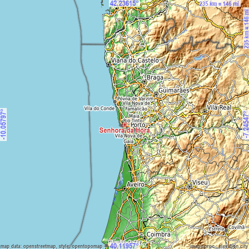
| \ | Map #1 | Map #2 | Topo.Map |
| Scale [m] | -6..145 m | -7..174 m | × |
| Scale [ft] | -20..476 ft | -23..571 ft | × |
| Average | 65.9 m = 216 ft | 68.6 m = 225 ft | × |
| Width | 7.35 km = 4.6 mi | 14.71 km = 9.1 mi | 235.3 km = 146.2 mi |
| Height | 7.35 km = 4.6 mi | 14.71 km = 9.1 mi | 235.3 km = 146.2 mi |
| ↑Max Latitude | 41.219474° | 41.252521° | 42.23615° |
| Latitude at center | 41.18641° | 41.18641° | 41.18641° |
| ↓Min Latitude | 41.15333° | 41.120233° | 40.11957° |
| ← Min Longitude | -8.695665° | -8.739611° | -10.05797° |
| Longitude center | -8.65172° | -8.65172° | -8.65172° |
| →Max Longitude | -8.607775° | -8.563829° | -7.24547° |
Nearby cities:
Cities around Senhora da Hora sort by population:
• Porto elevation 97 m
5.3 km,  140°
140°
• Maia 93 m
6.1 km,  25°
25°
• Matosinhos 17 m
3.2 km,  261°
261°
• São Mamede de Infesta 95 m
3.5 km,  79°
79°
• Leça da Palmeira 18 m
4.1 km,  277°
277°
• Leça do Bailio 84 m
3.2 km, 27°
• Moreira 82 m
6.8 km,  2°
2°
• Pedrouços 156 m
5.5 km,  87°
87°
• Foz do Douro 23 m
4.2 km,  202°
202°
• Guifões 80 m
1.9 km,  310°
310°
• Santa Cruz do Bispo 58 m
3.7 km,  329°
329°
• Milheirós 68 m
6.2 km,  59°
59°
Multilingual:
 En español:
Senhora da Hora elevación 85 m.
 En France:
Senhora da Hora élévation 85 m.
 Auf Deutsch:
Senhora da Hora höhe über dem Meeresspiegel ist 85 m.

Sources and notes:
- [note 1] Map square and city borders are not equal. Map elevation data is calculated only from area inside that square.
- [src 1] Elevation data from geonames database provided with same terms of usage.
- [src 2] The elevation map of Senhora da Hora is generated using elevation data from NASA's 3 arcsec (90m) resolution SRTM data.
- [src 3] Base (background) map © OpenStreetMap contributors tiles are generated by Geofabrik and OpenTopoMap.
Copyright & License:
This Senhora da Hora Elevation Map is licensed under CC BY-SA. You may reuse any part from this page, if you give a proper credit by linking to this URL:
 More info on terms of use page.