Viseu elevation
Viseu, Portugal elevation is 469 meters and Viseu elevation in feet is 1539 ft above sea level [src 1]. Viseu is a seat of a first-order administrative division (feature code) with elevation that is 301 meters (988 ft) bigger than average city elevation in Portugal.
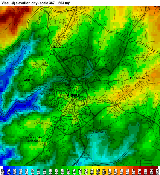
Below is the Elevation map of Viseu, which displays elevation range with different colors. Scale of the first map is from 367 to 603 m (1204 to 1978 ft) with average elevation of 467.6 meters (=1534 ft) [note 1]
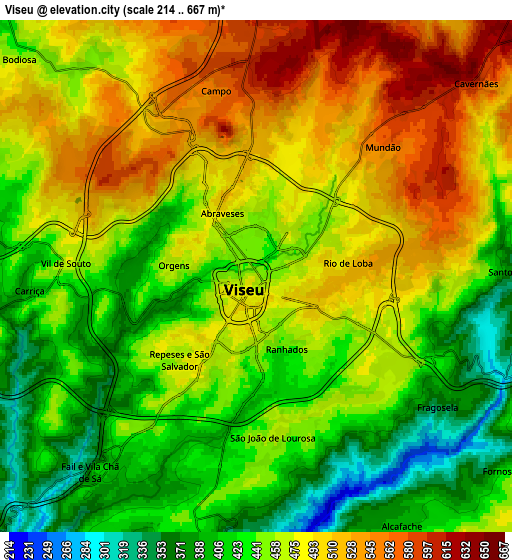
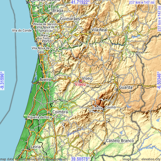
These maps also provides idea of topography and contour of this city, they are displayed at different zoom levels. More info about maps, scale and edge coordinates you can find below images.
| \ | Map #1 | Map #2 | Topo.Map |
| Scale [m] | 367..603 m | 214..667 m | × |
| Scale [ft] | 1204..1978 ft | 702..2188 ft | × |
| Average | 467.6 m = 1534 ft | 461.3 m = 1513 ft | × |
| Width | 7.41 km = 4.6 mi | 14.83 km = 9.2 mi | 237.2 km = 147.4 mi |
| Height | 7.41 km = 4.6 mi | 14.83 km = 9.2 mi | 237.2 km = 147.4 mi |
| ↑Max Latitude | 40.694338° | 40.727649° | 41.71922° |
| Latitude at center | 40.66101° | 40.66101° | 40.66101° |
| ↓Min Latitude | 40.627666° | 40.594305° | 39.58575° |
| ← Min Longitude | -7.953655° | -7.997601° | -9.31596° |
| Longitude center | -7.90971° | -7.90971° | -7.90971° |
| →Max Longitude | -7.865765° | -7.821819° | -6.50346° |
Nearby cities:
Cities around Viseu sort by population:
• Rio de Loba elevation 489 m
2.7 km,  78°
78°
• Abraveses 512 m
2.5 km,  337°
337°
• Mangualde 543 m
14 km,  116°
116°
• Tondela 305 m
21.6 km,  222°
222°
• Campo 591 m
5.6 km,  355°
355°
• Nelas 440 m
15.1 km,  161°
161°
• São Pedro do Sul 210 m
17.3 km,  307°
307°
• Sátão 606 m
17.4 km,  58°
58°
• Canas de Senhorim 357 m
17.9 km,  177°
177°
• Cabanas de Viriato 294 m
21.2 km,  194°
194°
• Campo de Besteiros 272 m
22.2 km,  238°
238°
• Vouzela 277 m
18.5 km,  292°
292°
Multilingual:
 En español:
Viseu elevación 469 m.
 En France:
Viseu élévation 469 m.


Sources and notes:
- [note 1] Map square and city borders are not equal. Map elevation data is calculated only from area inside that square.
- [src 1] Elevation data from geonames database provided with same terms of usage.
- [src 2] The elevation map of Viseu is generated using elevation data from NASA's 3 arcsec (90m) resolution SRTM data.
- [src 3] Base (background) map © OpenStreetMap contributors tiles are generated by Geofabrik and OpenTopoMap.
Copyright & License:
This Viseu Elevation Map is licensed under CC BY-SA. You may reuse any part from this page, if you give a proper credit by linking to this URL:
 More info on terms of use page.