Alcácer do Sal elevation
Alcácer do Sal (District of Setúbal), Portugal elevation is 49 meters and Alcácer do Sal elevation in feet is 161 ft above sea level [src 1]. Alcácer do Sal is a seat of a second-order administrative division (feature code) with elevation that is 119 meters (390 ft) smaller than average city elevation in Portugal.
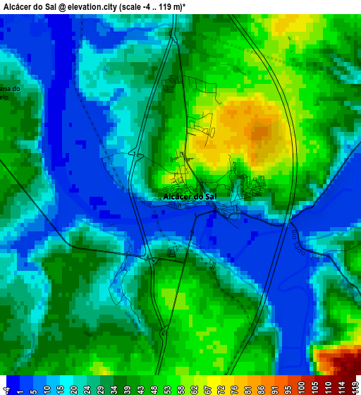
Below is the Elevation map of Alcácer do Sal, which displays elevation range with different colors. Scale of the first map is from -4 to 119 m (-13 to 390 ft) with average elevation of 31.2 meters (=102 ft) [note 1]
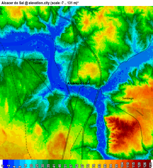
These maps also provides idea of topography and contour of this city, they are displayed at different zoom levels. More info about maps, scale and edge coordinates you can find below images.
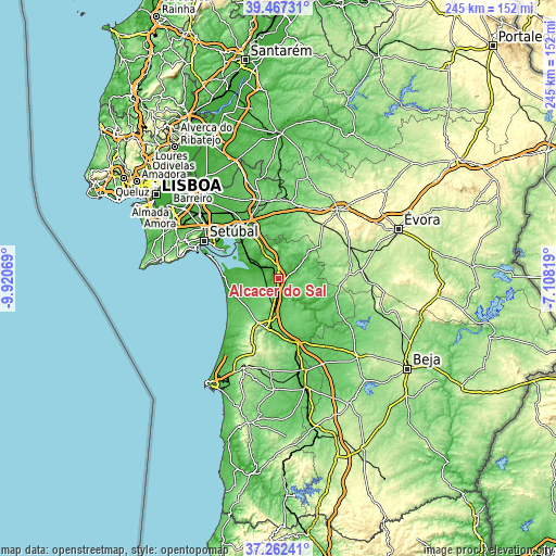
| \ | Map #1 | Map #2 | Topo.Map |
| Scale [m] | -4..119 m | -7..131 m | × |
| Scale [ft] | -13..390 ft | -23..430 ft | × |
| Average | 31.2 m = 102 ft | 47.8 m = 157 ft | × |
| Width | 7.66 km = 4.8 mi | 15.32 km = 9.5 mi | 245.2 km = 152.4 mi |
| Height | 7.66 km = 4.8 mi | 15.32 km = 9.5 mi | 245.2 km = 152.4 mi |
| ↑Max Latitude | 38.407704° | 38.442132° | 39.46731° |
| Latitude at center | 38.37326° | 38.37326° | 38.37326° |
| ↓Min Latitude | 38.338799° | 38.304322° | 37.26241° |
| ← Min Longitude | -8.558385° | -8.602331° | -9.92069° |
| Longitude center | -8.51444° | -8.51444° | -8.51444° |
| →Max Longitude | -8.470495° | -8.426549° | -7.10819° |
Nearby cities:
Cities around Alcácer do Sal sort by population:
• Setúbal elevation 16 m
36.6 km,  297°
297°
• Pinhal Novo 41 m
45 km,  309°
309°
• Azeitão 127 m
46.4 km,  290°
290°
• Palmela 190 m
40.1 km, 302°
• Montemor-o-Novo 247 m
40.2 km,  40°
40°
• Vendas Novas 148 m
34.1 km,  8°
8°
• Grândola 102 m
22.3 km,  191°
191°
• Santo André 32 m
41.9 km,  213°
213°
• Quinta do Anjo 94 m
43.1 km, 300°
• Santiago do Cacém 220 m
42.6 km,  201°
201°
• Comporta 9 m
23.7 km,  271°
271°
• Viana do Alentejo 249 m
44.7 km,  95°
95°
Multilingual:
 En español:
Alcácer do Sal elevación 49 m.
 En France:
Alcácer do Sal élévation 49 m.
 Auf Deutsch:
Alcácer do Sal höhe über dem Meeresspiegel ist 49 m.

Sources and notes:
- [note 1] Map square and city borders are not equal. Map elevation data is calculated only from area inside that square.
- [src 1] Elevation data from geonames database provided with same terms of usage.
- [src 2] The elevation map of Alcácer do Sal is generated using elevation data from NASA's 3 arcsec (90m) resolution SRTM data.
- [src 3] Base (background) map © OpenStreetMap contributors tiles are generated by Geofabrik and OpenTopoMap.
Copyright & License:
This Alcácer do Sal Elevation Map is licensed under CC BY-SA. You may reuse any part from this page, if you give a proper credit by linking to this URL:
 More info on terms of use page.