Alcantarilha elevation
Alcantarilha (Faro, Silves), Portugal elevation is 31 meters and Alcantarilha elevation in feet is 102 ft above sea level [src 1]. Alcantarilha is a populated place (feature code) with elevation that is 137 meters (449 ft) smaller than average city elevation in Portugal.
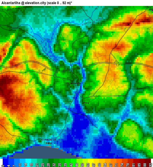
Below is the Elevation map of Alcantarilha, which displays elevation range with different colors. Scale of the first map is from 0 to 92 m (0 to 302 ft) with average elevation of 37.1 meters (=122 ft) [note 1]
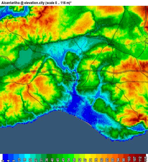
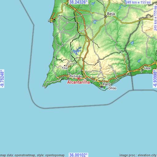
These maps also provides idea of topography and contour of this city, they are displayed at different zoom levels. More info about maps, scale and edge coordinates you can find below images.
| \ | Map #1 | Map #2 | Topo.Map |
| Scale [m] | 0..92 m | 0..116 m | × |
| Scale [ft] | 0..302 ft | 0..381 ft | × |
| Average | 37.1 m = 122 ft | 51.9 m = 170 ft | × |
| Width | 7.79 km = 4.8 mi | 15.58 km = 9.7 mi | 249.3 km = 154.9 mi |
| Height | 7.79 km = 4.8 mi | 15.58 km = 9.7 mi | 249.3 km = 154.9 mi |
| ↑Max Latitude | 37.165468° | 37.20048° | 38.24326° |
| Latitude at center | 37.13044° | 37.13044° | 37.13044° |
| ↓Min Latitude | 37.095396° | 37.060336° | 36.00102° |
| ← Min Longitude | -8.390175° | -8.434121° | -9.75248° |
| Longitude center | -8.34623° | -8.34623° | -8.34623° |
| →Max Longitude | -8.302285° | -8.258339° | -6.93998° |
Nearby cities:
Cities around Alcantarilha sort by population:
• Albufeira elevation 14 m
9.7 km,  118°
118°
• Silves 27 m
10.4 km,  308°
308°
• Estômbar 29 m
12.4 km,  278°
278°
• Lagoa 53 m
9.5 km,  273°
273°
• Ferreiras 80 m
9.6 km,  90°
90°
• Guia 49 m
4.1 km, 91°
• Armação de Pêra 8 m
3.2 km,  197°
197°
• Algoz 41 m
5.2 km,  46°
46°
• Carvoeiro 45 m
11.4 km,  251°
251°
• Porches 80 m
4.9 km, 265°
• Tunes 64 m
8.7 km,  62°
62°
• Pêra 41 m
0.9 km,  151°
151°
Multilingual:
 En español:
Alcantarilha elevación 31 m.
 En France:
Alcantarilha élévation 31 m.
 Auf Deutsch:
Alcantarilha höhe über dem Meeresspiegel ist 31 m.

Sources and notes:
- [note 1] Map square and city borders are not equal. Map elevation data is calculated only from area inside that square.
- [src 1] Elevation data from geonames database provided with same terms of usage.
- [src 2] The elevation map of Alcantarilha is generated using elevation data from NASA's 3 arcsec (90m) resolution SRTM data.
- [src 3] Base (background) map © OpenStreetMap contributors tiles are generated by Geofabrik and OpenTopoMap.
Copyright & License:
This Alcantarilha Elevation Map is licensed under CC BY-SA. You may reuse any part from this page, if you give a proper credit by linking to this URL:
 More info on terms of use page.