Laranjeiro elevation
Laranjeiro (Faro, Olhão), Portugal elevation is 36 meters and Laranjeiro elevation in feet is 118 ft above sea level [src 1]. Laranjeiro is a populated place (feature code) with elevation that is 132 meters (433 ft) smaller than average city elevation in Portugal.
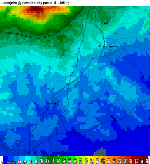
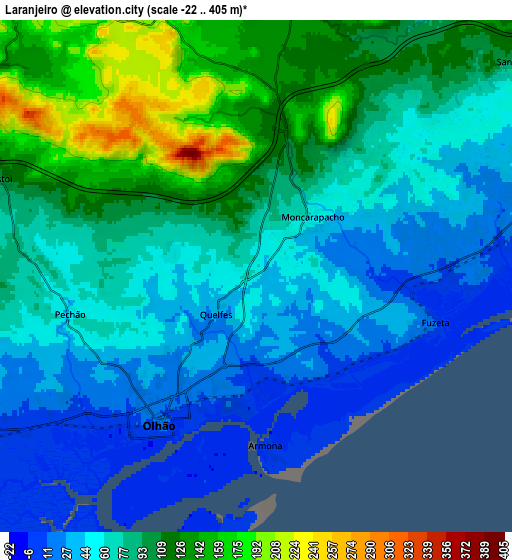
Below is the Elevation map of Laranjeiro, which displays elevation range with different colors. Scale of the first map is from -5 to 405 m (-16 to 1329 ft) with average elevation of 58.2 meters (=191 ft) [note 1]
These maps also provides idea of topography and contour of this city, they are displayed at different zoom levels. More info about maps, scale and edge coordinates you can find below images.
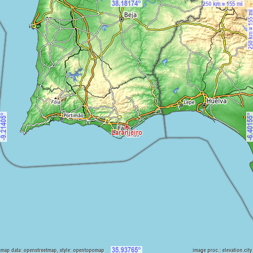
| \ | Map #1 | Map #2 | Topo.Map |
| Scale [m] | -5..405 m | -22..405 m | × |
| Scale [ft] | -16..1329 ft | -72..1329 ft | × |
| Average | 58.2 m = 191 ft | 76.8 m = 252 ft | × |
| Width | 7.8 km = 4.8 mi | 15.6 km = 9.7 mi | 249.5 km = 155 mi |
| Height | 7.8 km = 4.8 mi | 15.6 km = 9.7 mi | 249.5 km = 155 mi |
| ↑Max Latitude | 37.103047° | 37.138087° | 38.18174° |
| Latitude at center | 37.06799° | 37.06799° | 37.06799° |
| ↓Min Latitude | 37.032917° | 36.997828° | 35.93765° |
| ← Min Longitude | -7.851745° | -7.895691° | -9.21405° |
| Longitude center | -7.8078° | -7.8078° | -7.8078° |
| →Max Longitude | -7.763855° | -7.719909° | -6.40155° |
Nearby cities:
Cities around Laranjeiro sort by population:
• Faro elevation 12 m
11.9 km,  242°
242°
• Olhão 11 m
5.3 km,  214°
214°
• Tavira 9 m
15.6 km,  64°
64°
• São Brás de Alportel 254 m
11.8 km,  323°
323°
• Almancil 55 m
19.9 km,  276°
276°
• Moncarapacho 68 m
2.5 km,  45°
45°
• Santa Bárbara de Nexe 162 m
14.7 km,  286°
286°
• Luz 39 m
9.6 km,  73°
73°
• Estói 115 m
8.3 km, 291°
• Fuzeta 13 m
5.6 km,  105°
105°
• Santa Luzia 10 m
13.5 km, 73°
• Cabanas de Tavira 6 m
19.8 km, 67°
Multilingual:
 En español:
Laranjeiro elevación 36 m.
 En France:
Laranjeiro élévation 36 m.
 Auf Deutsch:
Laranjeiro höhe über dem Meeresspiegel ist 36 m.

Sources and notes:
- [note 1] Map square and city borders are not equal. Map elevation data is calculated only from area inside that square.
- [src 1] Elevation data from geonames database provided with same terms of usage.
- [src 2] The elevation map of Laranjeiro is generated using elevation data from NASA's 3 arcsec (90m) resolution SRTM data.
- [src 3] Base (background) map © OpenStreetMap contributors tiles are generated by Geofabrik and OpenTopoMap.
Copyright & License:
This Laranjeiro Elevation Map is licensed under CC BY-SA. You may reuse any part from this page, if you give a proper credit by linking to this URL:
 More info on terms of use page.