Moita elevation
Moita (District of Setúbal), Portugal elevation is 10 meters and Moita elevation in feet is 33 ft above sea level [src 1]. Moita is a seat of a second-order administrative division (feature code) with elevation that is 158 meters (518 ft) smaller than average city elevation in Portugal.
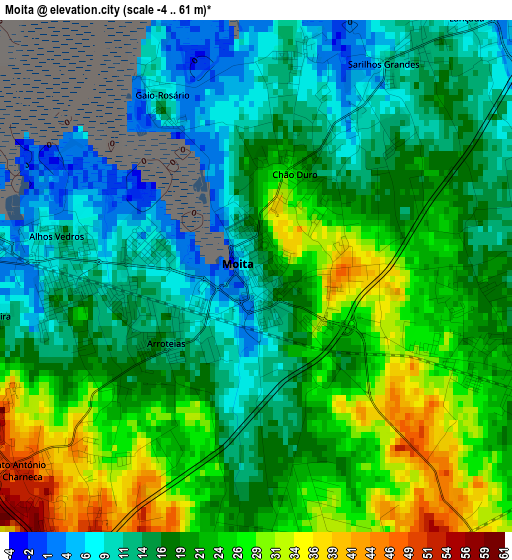
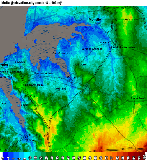
Below is the Elevation map of Moita, which displays elevation range with different colors. Scale of the first map is from -4 to 61 m (-13 to 200 ft) with average elevation of 18.9 meters (=62 ft) [note 1]
These maps also provides idea of topography and contour of this city, they are displayed at different zoom levels. More info about maps, scale and edge coordinates you can find below images.
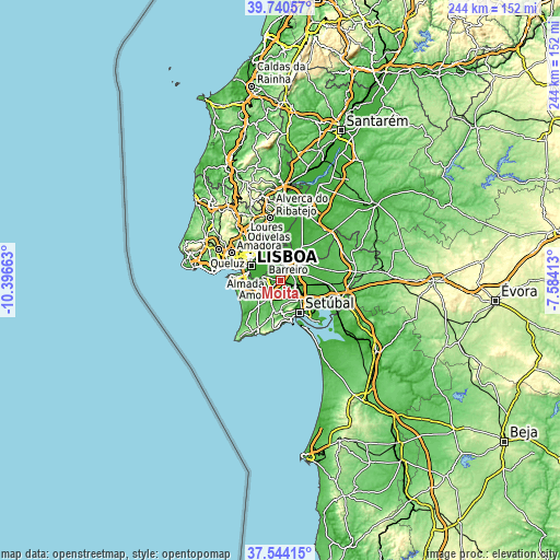
| \ | Map #1 | Map #2 | Topo.Map |
| Scale [m] | -4..61 m | -8..103 m | × |
| Scale [ft] | -13..200 ft | -26..338 ft | × |
| Average | 18.9 m = 62 ft | 27.2 m = 89 ft | × |
| Width | 7.63 km = 4.7 mi | 15.26 km = 9.5 mi | 244.2 km = 151.7 mi |
| Height | 7.63 km = 4.7 mi | 15.26 km = 9.5 mi | 244.2 km = 151.7 mi |
| ↑Max Latitude | 38.685092° | 38.719387° | 39.74057° |
| Latitude at center | 38.65078° | 38.65078° | 38.65078° |
| ↓Min Latitude | 38.616452° | 38.582107° | 37.54415° |
| ← Min Longitude | -9.034325° | -9.078271° | -10.39663° |
| Longitude center | -8.99038° | -8.99038° | -8.99038° |
| →Max Longitude | -8.946435° | -8.902489° | -7.58413° |
Nearby cities:
Cities around Moita sort by population:
• Barreiro elevation 7 m
7.3 km,  280°
280°
• Arrentela 33 m
10.1 km,  253°
253°
• Montijo 9 m
6.4 km,  12°
12°
• Pinhal Novo 41 m
7 km,  108°
108°
• Lavradio 10 m
5.7 km,  289°
289°
• Alhos Vedros 14 m
2.9 km, 278°
• Aldeia de Paio Pires 33 m
8.9 km,  244°
244°
• Santo António da Charneca 49 m
4.5 km,  231°
231°
• Samouco 11 m
7.8 km,  350°
350°
• Seixal 20 m
9.7 km,  262°
262°
• Rosairinho 6 m
3.3 km,  332°
332°
• Sarilhos Pequenos 9 m
3.5 km, 11°
Multilingual:
 En español:
Moita elevación 10 m.
 En France:
Moita élévation 10 m.


Sources and notes:
- [note 1] Map square and city borders are not equal. Map elevation data is calculated only from area inside that square.
- [src 1] Elevation data from geonames database provided with same terms of usage.
- [src 2] The elevation map of Moita is generated using elevation data from NASA's 3 arcsec (90m) resolution SRTM data.
- [src 3] Base (background) map © OpenStreetMap contributors tiles are generated by Geofabrik and OpenTopoMap.
Copyright & License:
This Moita Elevation Map is licensed under CC BY-SA. You may reuse any part from this page, if you give a proper credit by linking to this URL:
 More info on terms of use page.